
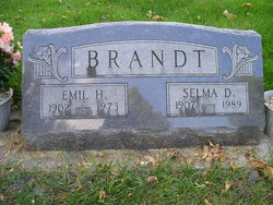


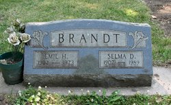
Selma Sophia Dorothea Graening Brandt
| Birth | : | 5 Feb 1907 Jefferson Township, Bremer County, Iowa, USA |
| Death | : | 9 Apr 1989 Waverly, Bremer County, Iowa, USA |
| Burial | : | Oak Hill Cemetery, Millersburg, Holmes County, USA |
| Coordinate | : | 40.5517980, -81.9103720 |
| Plot | : | Section I, Lot 168, Grave 4 |
frequently asked questions (FAQ):
-
Where is Selma Sophia Dorothea Graening Brandt's memorial?
Selma Sophia Dorothea Graening Brandt's memorial is located at: Oak Hill Cemetery, Millersburg, Holmes County, USA.
-
When did Selma Sophia Dorothea Graening Brandt death?
Selma Sophia Dorothea Graening Brandt death on 9 Apr 1989 in Waverly, Bremer County, Iowa, USA
-
Where are the coordinates of the Selma Sophia Dorothea Graening Brandt's memorial?
Latitude: 40.5517980
Longitude: -81.9103720
Family Members:
Parent
Spouse
Siblings
Flowers:


Nearby Cemetories:
1. Oak Hill Cemetery
Millersburg, Holmes County, USA
Coordinate: 40.5517980, -81.9103720
2. Millersburg City Park Cemetery
Millersburg, Holmes County, USA
Coordinate: 40.5508080, -81.9171400
3. Roman Raber Farm Cemetery
Millersburg, Holmes County, USA
Coordinate: 40.5658900, -81.9102400
4. Uhl Family Cemetery
Millersburg, Holmes County, USA
Coordinate: 40.5304260, -81.9338940
5. Old Crawford Cemetery
Holmesville, Holmes County, USA
Coordinate: 40.5902280, -81.9299470
6. Ira Kline Farm Cemetery
Benton, Holmes County, USA
Coordinate: 40.5727290, -81.8616310
7. Gindlesberger Cemetery
Millersburg, Holmes County, USA
Coordinate: 40.5884900, -81.8780600
8. Henry Hershberger Farm Cemetery
Saltillo, Holmes County, USA
Coordinate: 40.5399450, -81.8505690
9. Jonas W Miller Farm Cemetery
Benton, Holmes County, USA
Coordinate: 40.5840640, -81.8588500
10. Moses Coblentz Farm Cemetery
Millersburg, Holmes County, USA
Coordinate: 40.5535590, -81.8435420
11. Gray Ridge Community Fellowship Church Cemetery
Millersburg, Holmes County, USA
Coordinate: 40.5009600, -81.8956630
12. Anna Miller Farm Cemetery
Millersburg, Holmes County, USA
Coordinate: 40.5883660, -81.9591550
13. Abraham Mast Cemetery
Berlin, Holmes County, USA
Coordinate: 40.5907570, -81.8611370
14. Baker Ridge Cemetery
Killbuck, Holmes County, USA
Coordinate: 40.5164250, -81.9644700
15. Ivan D Troyer Farm Cemetery
Saltillo, Holmes County, USA
Coordinate: 40.5257790, -81.8461930
16. Martins Creek Mennonite Church Cemetery
Holmes County, USA
Coordinate: 40.5730705, -81.8411255
17. Samuel Hershberger Cemetery
Mount Hope, Holmes County, USA
Coordinate: 40.5959130, -81.8576400
18. Levi Hochstetler Farm Cemetery
Benton, Holmes County, USA
Coordinate: 40.5850182, -81.8442154
19. Holmes County Home Cemetery
Holmesville, Holmes County, USA
Coordinate: 40.6127370, -81.9152900
20. Monroe Lutheran Cemetery
Millersburg, Holmes County, USA
Coordinate: 40.5484070, -81.9929190
21. Andy D Miller Farm Cemetery
Berlin, Holmes County, USA
Coordinate: 40.5681390, -81.8303030
22. Christy Chapel Cemetery
Holmes County, USA
Coordinate: 40.5423200, -81.9936100
23. Salem Reformed Cemetery
Saltillo, Holmes County, USA
Coordinate: 40.5133970, -81.8412480
24. Pleasant Grove Cemetery
Killbuck, Holmes County, USA
Coordinate: 40.4933900, -81.9495843