Sgt Asa Elliott Camp
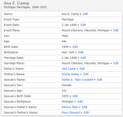
| Birth | : | Jan 1842 New York, USA |
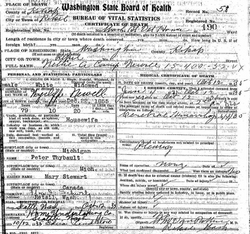
| Death | : | 23 Jan 1911 King County, Washington, USA |
| Burial | : | Lyvikens kyrkogård, Ludvika, Ludvika kommun, Sweden |
| Coordinate | : | 60.1378360, 15.1662830 |
| Plot | : | D 24 |
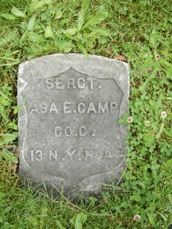
| Inscription | : | "Sergt. Asa E. Camp, Co. C., 13 NY HA." |
| Description | : | Although born and raised in NY, he settled in Minn. His profession was mining and mineral exploration. In his later years, he retired to Washington state. Asa served in the Civil War. He was a Sgt. in Co. C of the 37th NY Heavy Artillery. He lost much of his hearing as a result of the war. |
frequently asked questions (FAQ):
-
Where is Sgt Asa Elliott Camp's memorial?
Sgt Asa Elliott Camp's memorial is located at: Lyvikens kyrkogård, Ludvika, Ludvika kommun, Sweden.
-
When did Sgt Asa Elliott Camp death?
Sgt Asa Elliott Camp death on 23 Jan 1911 in King County, Washington, USA
-
Where are the coordinates of the Sgt Asa Elliott Camp's memorial?
Latitude: 60.1378360
Longitude: 15.1662830
Family Members:
Flowers:
Nearby Cemetories:
1. Lyvikens kyrkogård
Ludvika, Ludvika kommun, Sweden
Coordinate: 60.1378360, 15.1662830
2. Grängesberg Cemetery
Grangesberg, Ludvika kommun, Sweden
Coordinate: 60.0789760, 15.0266210
3. Smälla griftegård
Idkerberget, Borlänge kommun, Sweden
Coordinate: 60.3554776, 15.2147511
4. Saters Hospital Cemetery
Sater, Säters kommun, Sweden
Coordinate: 60.3367970, 15.6970542
5. Stora Tuna Kyrkogård
Borlänge, Borlänge kommun, Sweden
Coordinate: 60.4501730, 15.4786630
6. Skogskappellet, Västanfors
Fagersta, Fagersta kommun, Sweden
Coordinate: 59.9912440, 15.8036730
7. Hjulsjö
Hjulsjo, Hällefors kommun, Sweden
Coordinate: 59.7809413, 14.7806660
8. Husby Cemetery
Husby, Hedemora kommun, Sweden
Coordinate: 60.2436280, 16.0242460
9. Gagnefs kyrkogård
Gagnef, Gagnefs kommun, Sweden
Coordinate: 60.5898820, 15.0597170
10. Vika kyrkogard
Falun, Falu kommun, Sweden
Coordinate: 60.5133980, 15.7138820
11. Karbenning Cemetery
Karbenningby, Norbergs kommun, Sweden
Coordinate: 60.0083200, 16.0780800
12. Gåsborns Kyrkogård
Gasborn, Filipstads kommun, Sweden
Coordinate: 59.8801814, 14.3333281
13. Avesta kyrkogård
Avesta, Avesta kommun, Sweden
Coordinate: 60.1511400, 16.1545000
14. Kristine kyrka
Falun, Falu kommun, Sweden
Coordinate: 60.6077780, 15.6311110
15. Grytnäs kyrkogård
Avesta kommun, Sweden
Coordinate: 60.1661600, 16.2195020
16. Rämmens Kyrkogård
Rammen, Filipstads kommun, Sweden
Coordinate: 60.0312399, 14.1291666
17. Folkärna kyrkogård
Avesta, Avesta kommun, Sweden
Coordinate: 60.1527340, 16.3147520
18. Karlslunds kyrkogård
Nora kommun, Sweden
Coordinate: 59.5452279, 15.0307932
19. Leksands kyrkogård
Leksand, Leksands kommun, Sweden
Coordinate: 60.7318690, 14.9810310
20. Horndals kyrkogård
Horndal, Avesta kommun, Sweden
Coordinate: 60.2890838, 16.4036744
21. Fläckebo Kyrkogård
Flackebo, Sala kommun, Sweden
Coordinate: 59.8747220, 16.3436110
22. Östra kyrkogården
Filipstad, Filipstads kommun, Sweden
Coordinate: 59.7091290, 14.1780150
23. By gamla kyrkogård
Avesta kommun, Sweden
Coordinate: 60.2019709, 16.4776838
24. Rockesholms Kyrkogård
Grythyttan, Hällefors kommun, Sweden
Coordinate: 59.5357754, 14.6393867


