
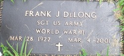
SGT Frank J. DeLong
| Birth | : | 28 Mar 1922 Kansas, USA |
| Death | : | 4 Mar 2001 Tecumseh, Shawnee County, Kansas, USA |
| Burial | : | Omaka Cemetery, Blenheim, Marlborough District, New Zealand |
| Coordinate | : | -41.5381800, 173.9401100 |
| Inscription | : | SERGEANT UNITED STATES ARMY WORLD WAR II |
| Description | : | Died at age 78. Frank was a Sergeant in the United States Army during World War II (1939-1945). THANK YOU FOR YOUR SERVICE. World War II, also known as the Second World War, was a global war that lasted from September 1, 1939 through September 2, 1945, though related conflicts began earlier. Married Doris Howbert in January, 1947 in Topeka, Kansas. Frank was 24 years old. Their children: Edward DeLong. Linda DeLong Montgomery. Doris DeLong Senne. 1940 United States Federal Census shows Frank living with his parents in Leavenworth, Leavenworth, Kansas. Frank was 18 years old and single. United States City Directories... Read More |
frequently asked questions (FAQ):
-
Where is SGT Frank J. DeLong's memorial?
SGT Frank J. DeLong's memorial is located at: Omaka Cemetery, Blenheim, Marlborough District, New Zealand.
-
When did SGT Frank J. DeLong death?
SGT Frank J. DeLong death on 4 Mar 2001 in Tecumseh, Shawnee County, Kansas, USA
-
Where are the coordinates of the SGT Frank J. DeLong's memorial?
Latitude: -41.5381800
Longitude: 173.9401100
Family Members:
Parent

Spouse
Siblings
Children
Flowers:


Nearby Cemetories:
1. Omaka Cemetery
Blenheim, Marlborough District, New Zealand
Coordinate: -41.5381800, 173.9401100
2. Old Renwick Cemetery
Marlborough District, New Zealand
Coordinate: -41.5014030, 173.8909900
3. Fairhall Cemetery
Blenheim, Marlborough District, New Zealand
Coordinate: -41.5294100, 173.8677800
4. Māori Island Urupā Otamawahu
Grovetown, Marlborough District, New Zealand
Coordinate: -41.4729310, 173.9778908
5. Rapaura Anglican Cemetery
Rapaura, Marlborough District, New Zealand
Coordinate: -41.4719700, 173.9014700
6. Rapaura Community Churchyard
Rapaura, Marlborough District, New Zealand
Coordinate: -41.4724800, 173.8995800
7. Pioneers Church Cemetery
Renwick, Marlborough District, New Zealand
Coordinate: -41.5091139, 173.8364765
8. Te Pokohiwi Urupā
Marlborough District, New Zealand
Coordinate: -41.5068950, 174.0612846
9. Wairau Bar Pilot House Graves
Spring Creek, Marlborough District, New Zealand
Coordinate: -41.4970923, 174.0582651
10. Ruakanakana Urupā
Kaituna, Marlborough District, New Zealand
Coordinate: -41.4463616, 173.8779400
11. Upper Wairau Valley Cemetery
Blenheim, Marlborough District, New Zealand
Coordinate: -41.5171130, 173.7974110
12. Wairau Affray Graves
Tuamarina, Marlborough District, New Zealand
Coordinate: -41.4285146, 173.9597007
13. Tuamarina Cemetery
Tuamarina, Marlborough District, New Zealand
Coordinate: -41.4280969, 173.9623665
14. Kaituna Cemetery
Kaituna, Marlborough District, New Zealand
Coordinate: -41.4694650, 173.8036590
15. Maher Family Cemetery
Kaituna, Marlborough District, New Zealand
Coordinate: -41.4682494, 173.7958289
16. Taylor Pass Cemetery
Seddon, Marlborough District, New Zealand
Coordinate: -41.6706624, 173.9871644
17. Seddon Cemetery
Seddon, Marlborough District, New Zealand
Coordinate: -41.6831810, 174.0582210
18. Langley Dale Cemetery
Marlborough District, New Zealand
Coordinate: -41.5076952, 173.7025647
19. Altimarlock Station
Altimarlock, Marlborough District, New Zealand
Coordinate: -41.7387595, 173.8579141
20. Robin Hood Bay Urupā
Marlborough District, New Zealand
Coordinate: -41.3541665, 174.0768701
21. Ocean Bay
Ocean Bay, Marlborough District, New Zealand
Coordinate: -41.3333300, 174.1000000
22. Kakapo Bay Cemetery
Kakapo Bay, Marlborough District, New Zealand
Coordinate: -41.3240576, 174.1040946
23. Whangatoetoe Bay
Marlborough District, New Zealand
Coordinate: -41.3414261, 174.1410659
24. Picton Gaolyard
Picton, Marlborough District, New Zealand
Coordinate: -41.2933357, 174.0046601