


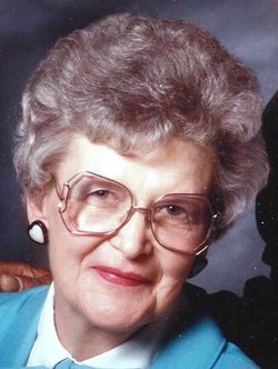
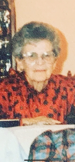

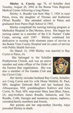
Shirley A. Rundle Currie
| Birth | : | 7 May 1926 Paton, Greene County, Iowa, USA |
| Death | : | 20 Aug 2002 Storm Lake, Buena Vista County, Iowa, USA |
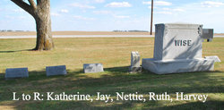
| Burial | : | St. Joseph and St. Joachim Catholic Cemetery, Ōtāhūhū, Auckland Council, New Zealand |
| Coordinate | : | -36.9436100, 174.8490100 |
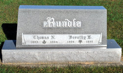
| Description | : | Shirley's mother, Katherine died when Shirley was only 2 years old. Shirley graduated from Paton High School and went on to the Methodist School of Nursing, graduating from there in 1947. Shirley was employed as Registered Nurse in the Sac City Hospital until March 1948 when she and Ray Currie were married. She then worked in the Buena Vista Hospital for 19 years, and as a public health nurse in that county for six years before retiring. |
frequently asked questions (FAQ):
-
Where is Shirley A. Rundle Currie's memorial?
Shirley A. Rundle Currie's memorial is located at: St. Joseph and St. Joachim Catholic Cemetery, Ōtāhūhū, Auckland Council, New Zealand.
-
When did Shirley A. Rundle Currie death?
Shirley A. Rundle Currie death on 20 Aug 2002 in Storm Lake, Buena Vista County, Iowa, USA
-
Where are the coordinates of the Shirley A. Rundle Currie's memorial?
Latitude: -36.9436100
Longitude: 174.8490100
Family Members:
Parent
Spouse
Flowers:


Nearby Cemetories:
1. St. Joseph and St. Joachim Catholic Cemetery
Ōtāhūhū, Auckland Council, New Zealand
Coordinate: -36.9436100, 174.8490100
2. Holy Trinity Memorial Park
Ōtāhūhū, Auckland Council, New Zealand
Coordinate: -36.9374510, 174.8448580
3. Nixon Memorial
Ōtāhūhū, Auckland Council, New Zealand
Coordinate: -36.9499366, 174.8449909
4. Otahuhu Public Cemetery
Ōtāhūhū, Auckland Council, New Zealand
Coordinate: -36.9377500, 174.8432390
5. St. John's Presbyterian Church Cemetery
Papatoetoe, Auckland Council, New Zealand
Coordinate: -36.9674185, 174.8598178
6. St. John's Church Cemetery
East Tamaki, Auckland Council, New Zealand
Coordinate: -36.9522250, 174.8964540
7. St Matthias Churchyard
Panmure, Auckland Council, New Zealand
Coordinate: -36.9053300, 174.8577200
8. St. Patrick's Roman Catholic Church Cemetery
Panmure, Auckland Council, New Zealand
Coordinate: -36.9029680, 174.8564960
9. Waikaraka Cemetery
Ōnehunga, Auckland Council, New Zealand
Coordinate: -36.9297140, 174.7967170
10. Papatoetoe Cemetery
Papatoetoe, Auckland Council, New Zealand
Coordinate: -36.9893110, 174.8373530
11. Flat Bush Cemetery
East Tamaki, Auckland Council, New Zealand
Coordinate: -36.9563500, 174.9097100
12. St. Paul's Anglican Cemetery
East Tamaki, Auckland Council, New Zealand
Coordinate: -36.9615200, 174.9082000
13. Pakuranga Methodist Cemetery
Pakuranga, Auckland Council, New Zealand
Coordinate: -36.9054000, 174.8914900
14. Manukau Memorial Gardens
Manukau, Auckland Council, New Zealand
Coordinate: -36.9944380, 174.8397300
15. Mangere Piriti Urupā St. James Churchyard
Mangere, Auckland Council, New Zealand
Coordinate: -36.9418970, 174.7835260
16. Onehunga Catholic Cemetery
Ōnehunga, Auckland Council, New Zealand
Coordinate: -36.9224360, 174.7884560
17. Our Lady of the Assumption Catholic Church
Ōnehunga, Auckland Council, New Zealand
Coordinate: -36.9223690, 174.7884530
18. Mangere Lawn Cemetery
Mangere, Auckland Council, New Zealand
Coordinate: -36.9626150, 174.7857000
19. Mangere Presbyterian Cemetery
Mangere, Auckland Council, New Zealand
Coordinate: -36.9750197, 174.7924783
20. St. Peter's Anglican Cemetery
Ōnehunga, Auckland Council, New Zealand
Coordinate: -36.9227113, 174.7847550
21. Howick Historical Village
Pakuranga, Auckland Council, New Zealand
Coordinate: -36.9067680, 174.9027080
22. Woodside Methodist Cemetery
Manukau, Auckland Council, New Zealand
Coordinate: -36.9929680, 174.8837860
23. Point England Presbyterian Cemetery
Point England, Auckland Council, New Zealand
Coordinate: -36.8823420, 174.8601550
24. St. David's Anglican Churchyard
Wiri, Auckland Council, New Zealand
Coordinate: -37.0025400, 174.8886150