
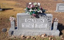

Shirley Jean Gerlach Dalstein
| Birth | : | 4 Oct 1935 |
| Death | : | 25 Jul 2004 |
| Burial | : | McGirk Cemetery, McGirk, Moniteau County, USA |
| Coordinate | : | 38.6143300, -92.4721500 |
| Description | : | Jefferson City News-Tribune (MO) - Monday, July 26, 2004: Shirley Jean Dalstein, 68, California, Mo., died Sunday, July 25, 2004 at her daughter's home near Latham, Mo. Survived by three daughters, Wilma Dalstein of Latham, Mo., Edith Dalstein of California, Mo., and Ruby Pettigrew of Latham, Mo., one brother, Frederick Gerlach, two sisters, Hilda Kirchhoff, and Betty Swillum, one grandson, Cole Pettigrew. Funeral services will be at Bowlin-Cantriel Funeral Services in California, Mo. on Wednesday, July 28, at 10:00 a.m. Officiating will be Rev. Dr. Peter Kurowski. Eulogy will be by Chaplain Bart Larson. Burial will be... Read More |
frequently asked questions (FAQ):
-
Where is Shirley Jean Gerlach Dalstein's memorial?
Shirley Jean Gerlach Dalstein's memorial is located at: McGirk Cemetery, McGirk, Moniteau County, USA.
-
When did Shirley Jean Gerlach Dalstein death?
Shirley Jean Gerlach Dalstein death on 25 Jul 2004 in
-
Where are the coordinates of the Shirley Jean Gerlach Dalstein's memorial?
Latitude: 38.6143300
Longitude: -92.4721500
Family Members:
Parent

Spouse

Siblings
Children

Flowers:


Nearby Cemetories:
1. McGirk Cemetery
McGirk, Moniteau County, USA
Coordinate: 38.6143300, -92.4721500
2. McGirk-George Cemetery
McGirk, Moniteau County, USA
Coordinate: 38.6115500, -92.4679500
3. Old Lebanon Cemetery
McGirk, Moniteau County, USA
Coordinate: 38.6321983, -92.4888992
4. County Farm Cemetery
California, Moniteau County, USA
Coordinate: 38.6103548, -92.5077443
5. Schmutz Cemetery
Moniteau County, USA
Coordinate: 38.6321983, -92.5018997
6. Swiss Cemetery
California, Moniteau County, USA
Coordinate: 38.6324600, -92.5021100
7. Salem United Church of Christ Cemetery
Moniteau County, USA
Coordinate: 38.5864300, -92.5045400
8. Griner Family Cemetery
California, Moniteau County, USA
Coordinate: 38.6293900, -92.5213200
9. Evangelical Lutheran Emanuel Cemetery
Centertown, Cole County, USA
Coordinate: 38.6173820, -92.4191208
10. Pioneer Public Cemetery
McGirk, Moniteau County, USA
Coordinate: 38.6180100, -92.5309700
11. Sweetwater Cemetery
Moniteau County, USA
Coordinate: 38.6567001, -92.4411011
12. Murray Cemetery
Centertown, Cole County, USA
Coordinate: 38.5936012, -92.4152985
13. Borghardt Gravesite
California, Moniteau County, USA
Coordinate: 38.6411400, -92.5254800
14. Brown Family Cemetery
California, Moniteau County, USA
Coordinate: 38.5862100, -92.5308800
15. Centertown Cemetery
Centertown, Cole County, USA
Coordinate: 38.6188660, -92.4031677
16. Old California City Cemetery
California, Moniteau County, USA
Coordinate: 38.6311200, -92.5441700
17. Bowlen Cemetery
California, Moniteau County, USA
Coordinate: 38.6500015, -92.5366974
18. Crown Hill City Cemetery
California, Moniteau County, USA
Coordinate: 38.6272060, -92.5508770
19. Evangelical Cemetery
California, Moniteau County, USA
Coordinate: 38.6273100, -92.5513700
20. California City Cemetery
California, Moniteau County, USA
Coordinate: 38.6275170, -92.5518830
21. New Hope Cemetery
California, Moniteau County, USA
Coordinate: 38.6792800, -92.4774100
22. California Masonic Cemetery
California, Moniteau County, USA
Coordinate: 38.6276900, -92.5547300
23. Chambers Cemetery
Elston, Cole County, USA
Coordinate: 38.6166153, -92.3853836
24. Anderson Cemetery
Moniteau County, USA
Coordinate: 38.6130500, -92.5617700