
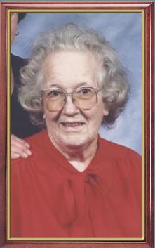
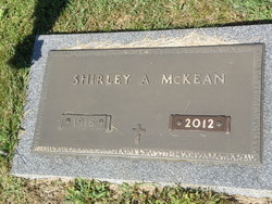
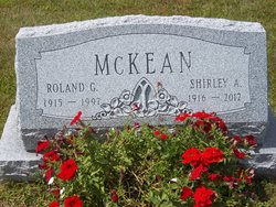
Shirley May Avery McKean
| Birth | : | 13 Dec 1916 Woodstock, Grafton County, New Hampshire, USA |
| Death | : | 23 May 2012 Franconia, Grafton County, New Hampshire, USA |
| Burial | : | Center Haverhill Cemetery, Center Haverhill, Grafton County, USA |
| Coordinate | : | 44.0770650, -71.9868740 |
| Description | : | North Haverhill, NH – Shirley May McKean, 95, formerly of Airport Road, died May 23, 2012 at the Lafayette Center, Franconia, NH. She was born in Woodstock, NH, December 13, 1916, to Leigh and Mary O. (Smith) Avery. Shirley was a graduated from the Woodstock High School and the Plymouth Normal School. She taught elementary school and later was a dietary aid and coordinator of volunteers at Grafton County Nursing Home. She married Roland G. McKean on December 22, 1945. Shirley was a life member of the VFW Auxiliary Post #5245 in North Haverhill. She belonged to the North Haverhill... Read More |
frequently asked questions (FAQ):
-
Where is Shirley May Avery McKean's memorial?
Shirley May Avery McKean's memorial is located at: Center Haverhill Cemetery, Center Haverhill, Grafton County, USA.
-
When did Shirley May Avery McKean death?
Shirley May Avery McKean death on 23 May 2012 in Franconia, Grafton County, New Hampshire, USA
-
Where are the coordinates of the Shirley May Avery McKean's memorial?
Latitude: 44.0770650
Longitude: -71.9868740
Family Members:
Parent

Spouse

Siblings
Flowers:


Nearby Cemetories:
1. Center Haverhill Cemetery
Center Haverhill, Grafton County, USA
Coordinate: 44.0770650, -71.9868740
2. Abbott Cemetery
North Haverhill, Grafton County, USA
Coordinate: 44.0821730, -72.0186420
3. Oxbow Cemetery
Newbury, Orange County, USA
Coordinate: 44.0881830, -72.0486670
4. East Haverhill Cemetery
East Haverhill, Grafton County, USA
Coordinate: 44.0289688, -71.9889297
5. Horse Meadow Annex Cemetery
North Haverhill, Grafton County, USA
Coordinate: 44.1056820, -72.0408260
6. Horse Meadow Cemetery
North Haverhill, Grafton County, USA
Coordinate: 44.1068880, -72.0405500
7. Number 6 Cemetery
East Haverhill, Grafton County, USA
Coordinate: 44.0326400, -71.9518600
8. Swiftwater Cemetery
Bath, Grafton County, USA
Coordinate: 44.1303400, -71.9574300
9. Ladd Street Cemetery
Haverhill, Grafton County, USA
Coordinate: 44.0439600, -72.0532800
10. Pine Grove Cemetery
Woodsville, Grafton County, USA
Coordinate: 44.1380997, -72.0188980
11. West Cemetery
Benton, Grafton County, USA
Coordinate: 44.1033700, -71.9014000
12. East Cemetery
Benton, Grafton County, USA
Coordinate: 44.0985985, -71.8846970
13. Rodimon-Cross Cemetery
Piermont, Grafton County, USA
Coordinate: 43.9901100, -71.9924500
14. Wells River Cemetery
Wells River, Orange County, USA
Coordinate: 44.1535988, -72.0547028
15. Lund Cemetery
Warren, Grafton County, USA
Coordinate: 43.9882800, -71.9589200
16. Oliverian Road Cemetery
Benton, Grafton County, USA
Coordinate: 43.9978145, -71.9209265
17. Bath Village Cemetery
Bath, Grafton County, USA
Coordinate: 44.1693500, -71.9617800
18. West Bath Cemetery
Bath, Grafton County, USA
Coordinate: 44.1750930, -71.9865080
19. West Newbury Cemetery
West Newbury, Orange County, USA
Coordinate: 44.0591800, -72.1246900
20. Town House Cemetery
Newbury Center, Orange County, USA
Coordinate: 44.1066322, -72.1256943
21. Brown Farmstead Cemetery
Benton, Grafton County, USA
Coordinate: 44.0778000, -71.8420830
22. Carbee Cemetery
Bath, Grafton County, USA
Coordinate: 44.1724640, -72.0466980
23. Rogers Hill Cemetery
West Newbury, Orange County, USA
Coordinate: 44.0550003, -72.1322021
24. Boltonville Cemetery
Boltonville, Orange County, USA
Coordinate: 44.1575012, -72.0877991