
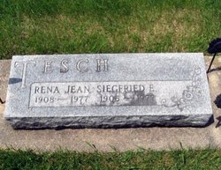
Siegfried Emil Tesch
| Birth | : | 14 Dec 1905 Mitchell County, Iowa, USA |
| Death | : | 10 Nov 1977 Prescott Valley, Yavapai County, Arizona, USA |
| Burial | : | Osage Cemetery, Osage, Mitchell County, USA |
| Coordinate | : | 43.2916700, -92.8201700 |
| Description | : | PRESCOTT, ARIZONA — An Osage couple was killed about 10 miles south of here when they ran across State Route 69 in front of an oncoming car, the Department of Public Safety said. Officers identified the victims as Siegfried E. Tesch, 71, and Rena Jean Tesch, 68. The Teschs had been visiting a daughter in Texas and were in route to Fort Collins, Colorado, to visit another daughter and had stopped overnight in Prescott. They reportedly left their motel and walked to a shopping center to buy groceries. As they returned to their motel, they crossed the highway and were... Read More |
frequently asked questions (FAQ):
-
Where is Siegfried Emil Tesch's memorial?
Siegfried Emil Tesch's memorial is located at: Osage Cemetery, Osage, Mitchell County, USA.
-
When did Siegfried Emil Tesch death?
Siegfried Emil Tesch death on 10 Nov 1977 in Prescott Valley, Yavapai County, Arizona, USA
-
Where are the coordinates of the Siegfried Emil Tesch's memorial?
Latitude: 43.2916700
Longitude: -92.8201700
Family Members:
Parent

Spouse

Siblings

Flowers:


Nearby Cemetories:
1. Osage Cemetery
Osage, Mitchell County, USA
Coordinate: 43.2916700, -92.8201700
2. Sacred Heart Cemetery
Osage, Mitchell County, USA
Coordinate: 43.2742004, -92.7917023
3. South Osage Mennonite Church Cemetery
Osage, Mitchell County, USA
Coordinate: 43.2544556, -92.7915573
4. Tucker Cemetery
Osage, Mitchell County, USA
Coordinate: 43.2494011, -92.8319016
5. Oak Grove Cemetery
Mitchell, Mitchell County, USA
Coordinate: 43.3156013, -92.8707962
6. Calvary Cemetery
Osage, Mitchell County, USA
Coordinate: 43.2238998, -92.8300018
7. Orchard Cemetery
Orchard, Mitchell County, USA
Coordinate: 43.2249985, -92.7838898
8. Dudley Cemetery
Dudley (historical), Mitchell County, USA
Coordinate: 43.2252998, -92.8743973
9. Riverview Cemetery
Saint Ansgar, Mitchell County, USA
Coordinate: 43.3430328, -92.9220200
10. Rock Creek Cemetery
Meroa, Mitchell County, USA
Coordinate: 43.2352791, -92.9225006
11. Eden Presbyterian Cemetery
Meroa, Mitchell County, USA
Coordinate: 43.2131004, -92.9103012
12. West End Cemetery
Meroa, Mitchell County, USA
Coordinate: 43.2216682, -92.9250031
13. Saint Ansgar Cemetery
Saint Ansgar, Mitchell County, USA
Coordinate: 43.3777809, -92.9094391
14. Immanuel Lutheran Cemetery
Saint Ansgar, Mitchell County, USA
Coordinate: 43.3717003, -92.9257965
15. First Lutheran Cemetery
Saint Ansgar, Mitchell County, USA
Coordinate: 43.3841705, -92.9194412
16. Liberty Cemetery
Little Cedar, Mitchell County, USA
Coordinate: 43.3856010, -92.7230988
17. Beaver Creek Cemetery
Brownville, Mitchell County, USA
Coordinate: 43.3397217, -92.6727829
18. Blakestad Cemetery
Saint Ansgar, Mitchell County, USA
Coordinate: 43.3711014, -92.9400024
19. Saint Johns Lutheran Cemetery
Rock Creek, Mitchell County, USA
Coordinate: 43.3295560, -92.9849770
20. Saint Peters Cemetery
New Haven, Mitchell County, USA
Coordinate: 43.2858315, -92.6427765
21. Saint Johns Lutheran Old Cemetery
Rock Creek, Mitchell County, USA
Coordinate: 43.3313904, -92.9897232
22. Stillwater Cemetery
Orchard, Mitchell County, USA
Coordinate: 43.2130585, -92.6780624
23. McKinley Cemetery
Saint Ansgar, Mitchell County, USA
Coordinate: 43.3906400, -92.9368300
24. Howardville Cemetery
Floyd, Floyd County, USA
Coordinate: 43.1866989, -92.7016983