
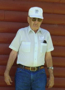
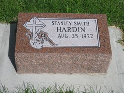
Stanley Smith Hardin
| Birth | : | 25 Aug 1922 Sheridan County, Nebraska, USA |
| Death | : | 7 Oct 2015 Gordon, Sheridan County, Nebraska, USA |
| Burial | : | Gordon Cemetery, Gordon, Sheridan County, USA |
| Coordinate | : | 42.7858009, -102.2102966 |
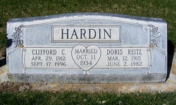
| Description | : | Stanley Hardin Aug 25,1922-Oct 7,2015 Stanley Smith Hardin was born August 25, 1922, at the Adams Farm, 10 miles northwest of Gordon to Harold and Nellie Hardin. He was baptized in April of 1965. He passed away October 7, 2015, at the Gordon Memorial Hospital.He went to school four miles northwest of the farm at District 94, and went through the 4th grade. On March 1, 1935, his folks moved on his grandfather and grandmother's farm, 4 ½ miles west of Gordon. He finished the 4th grade there and 7 ½ years at Pleasant Hill School, 5 miles... Read More |
frequently asked questions (FAQ):
-
Where is Stanley Smith Hardin's memorial?
Stanley Smith Hardin's memorial is located at: Gordon Cemetery, Gordon, Sheridan County, USA.
-
When did Stanley Smith Hardin death?
Stanley Smith Hardin death on 7 Oct 2015 in Gordon, Sheridan County, Nebraska, USA
-
Where are the coordinates of the Stanley Smith Hardin's memorial?
Latitude: 42.7858009
Longitude: -102.2102966
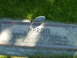
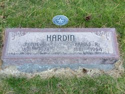
Family Members:
Parent
Siblings


Flowers:


Nearby Cemetories:
1. Gordon Cemetery
Gordon, Sheridan County, USA
Coordinate: 42.7858009, -102.2102966
2. Mount Hope Cemetery
Gordon, Sheridan County, USA
Coordinate: 42.7113991, -102.2241974
3. Dane Cemetery
Cherry County, USA
Coordinate: 42.7924300, -102.0824700
4. Bethel Cemetery
Sheridan County, USA
Coordinate: 42.9011002, -102.3208008
5. Lavaca Cemetery
Irwin, Cherry County, USA
Coordinate: 42.7332993, -102.0175018
6. Amity Cemetery
Sheridan County, USA
Coordinate: 42.8036003, -102.4389038
7. Fair View Cemetery
Rushville, Sheridan County, USA
Coordinate: 42.7155991, -102.4325027
8. Saint Aloysius Cemetery
Sheridan County, USA
Coordinate: 42.9015500, -102.4025500
9. Saint Marys Cemetery
Rushville, Sheridan County, USA
Coordinate: 42.7174988, -102.4436035
10. Feather on Head Cemetery
Oglala Lakota County, USA
Coordinate: 43.0311012, -102.1611023
11. Holly Cemetery
Rushville, Sheridan County, USA
Coordinate: 42.8575120, -102.5370990
12. Novotny Cemetery
Hay Springs, Sheridan County, USA
Coordinate: 42.7742004, -102.5963974
13. Davis Cemetery
Rushville, Sheridan County, USA
Coordinate: 42.5421000, -102.4118800
14. Wolf Creek Community Cemetery
Oglala Lakota County, USA
Coordinate: 43.0405750, -102.3966490
15. Spotted Bear Family Cemetery
Denby, Oglala Lakota County, USA
Coordinate: 43.0608200, -102.3376600
16. Preble Cemetery
Sheridan County, USA
Coordinate: 42.6504000, -102.5765000
17. Abold Family Cemetery
Rushville, Sheridan County, USA
Coordinate: 42.8863500, -102.6158000
18. Bomar Cemetery
Hay Springs, Sheridan County, USA
Coordinate: 42.8062000, -102.6459600
19. Native American Cemetery
Oglala, Oglala Lakota County, USA
Coordinate: 43.0886002, -102.3550034
20. White Clay Cemetery
Rushville, Sheridan County, USA
Coordinate: 42.9732820, -102.5667230
21. Knight Cemetery
Oglala Lakota County, USA
Coordinate: 43.1039009, -102.1200027
22. Holy Cross Cemetery
Pine Ridge, Oglala Lakota County, USA
Coordinate: 43.0194016, -102.5503006
23. Pine Ridge Presbyterian Cemetery
Pine Ridge, Oglala Lakota County, USA
Coordinate: 43.0235200, -102.5506200
24. Beguin Cemetery
Sheridan County, USA
Coordinate: 42.5107994, -102.4982986