
| Birth | : | 1747 Old Saybrook, Middlesex County, Connecticut, USA |
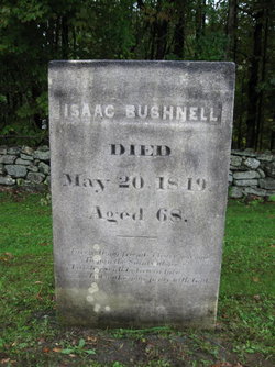
| Death | : | 14 Jun 1821 West Hartland, Hartford County, Connecticut, USA |
| Burial | : | Pleasant Grove Cemetery, Pleasant Grove, Johnson County, USA |
| Coordinate | : | 37.4405600, -89.0305600 |
| Description | : | Christened 22 March 1748 Saybrook, Middlesex, Connecticut. |
frequently asked questions (FAQ):
-
Where is Stephen Bushnell's memorial?
Stephen Bushnell's memorial is located at: Pleasant Grove Cemetery, Pleasant Grove, Johnson County, USA.
-
When did Stephen Bushnell death?
Stephen Bushnell death on 14 Jun 1821 in West Hartland, Hartford County, Connecticut, USA
-
Where are the coordinates of the Stephen Bushnell's memorial?
Latitude: 37.4405600
Longitude: -89.0305600
Family Members:
Parent

Spouse
Siblings
Children
Flowers:


Nearby Cemetories:
1. Pleasant Grove Cemetery
Pleasant Grove, Johnson County, USA
Coordinate: 37.4405600, -89.0305600
2. Old Mount Pleasant Cemetery
Union County, USA
Coordinate: 37.4456730, -89.0709580
3. Mount Pleasant Mennonite School Cemetery
Dongola, Union County, USA
Coordinate: 37.4439940, -89.0764190
4. Allen Cemetery
Johnson County, USA
Coordinate: 37.4791985, -89.0299988
5. Mount Zion Cemetery
Union County, USA
Coordinate: 37.4110985, -89.0653000
6. Mount Pisgah Cemetery
Cypress, Johnson County, USA
Coordinate: 37.4000015, -89.0242004
7. Mount Pleasant Mennonite Church Cemetery
Dongola, Union County, USA
Coordinate: 37.4453000, -89.0849630
8. Jenkins Cemetery
Buncombe, Johnson County, USA
Coordinate: 37.4688988, -88.9882965
9. McGinnis Cemetery
Anna, Union County, USA
Coordinate: 37.4435997, -89.0986023
10. Church Of God Cemetery
Cypress, Johnson County, USA
Coordinate: 37.3857400, -89.0111700
11. Goddard Cemetery
Lick Creek, Union County, USA
Coordinate: 37.4958000, -89.0563965
12. Fain Cemetery
Johnson County, USA
Coordinate: 37.3907460, -88.9810930
13. File Cemetery
Johnson County, USA
Coordinate: 37.4113998, -88.9582977
14. Mount Zion Cemetery
Buncombe, Johnson County, USA
Coordinate: 37.4741000, -88.9611400
15. Bridges Cemetery
West Vienna, Johnson County, USA
Coordinate: 37.4081001, -88.9539032
16. Simpson Cemetery
Buncombe, Johnson County, USA
Coordinate: 37.4693985, -88.9480972
17. Friendship Cemetery
Dongola, Union County, USA
Coordinate: 37.3842300, -89.0891600
18. Peterson Cemetery
Johnson County, USA
Coordinate: 37.4930992, -88.9653015
19. Cedar Grove Cemetery
Elvira, Johnson County, USA
Coordinate: 37.5154000, -89.0262000
20. Francis Cemetery
Vienna, Johnson County, USA
Coordinate: 37.4143982, -88.9375000
21. Johnson County Poor Farm Cemetery
Elvira, Johnson County, USA
Coordinate: 37.4597220, -88.9333330
22. Bethany Church Cemetery
Dongola, Union County, USA
Coordinate: 37.3615460, -89.0449350
23. Gurley Cemetery
Johnson County, USA
Coordinate: 37.5200005, -89.0056000
24. King Neptune Memorial
Anna, Union County, USA
Coordinate: 37.4657460, -89.1324740