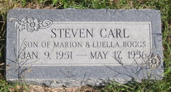
Steven Carl Boggs
| Birth | : | 9 Jan 1951 Emporia, Lyon County, Kansas, USA |
| Death | : | 17 May 1956 Wichita, Sedgwick County, Kansas, USA |
| Burial | : | Frisco Springs Cemetery, Benton County, USA |
| Coordinate | : | 36.2714005, -94.0766983 |
| Inscription | : | SON OF MARION & LUELLA BOGGS |
| Description | : | The Emporia Gazette, 18 May 1956, Friday; p. 6, c. 6 STEVEN CARL BOGGS DIES Steven Carl Boggs, young son of Mr. and Mrs. Marion L. and Luella F. Effland Boggs, Rt. 4, Emporia, died in Wesley Hospital, Wichita, Thursday afternoon at 4:30 o'clock. Funeral services will be held in the Roberts-Blue-Barnett Chapel Sunday afternoon at 2 o'clock, conducted by the Rev. Willis Clark, pastor of the Hartford Christian Church. Burial will be in the Chicago Mound Cemetery. Steven Boggs was born Jan. 9, 1951, in Emporia. He is survived by his parents, of the home;... Read More |
frequently asked questions (FAQ):
-
Where is Steven Carl Boggs's memorial?
Steven Carl Boggs's memorial is located at: Frisco Springs Cemetery, Benton County, USA.
-
When did Steven Carl Boggs death?
Steven Carl Boggs death on 17 May 1956 in Wichita, Sedgwick County, Kansas, USA
-
Where are the coordinates of the Steven Carl Boggs's memorial?
Latitude: 36.2714005
Longitude: -94.0766983
Family Members:
Parent
Flowers:
Nearby Cemetories:
1. Frisco Springs Cemetery
Benton County, USA
Coordinate: 36.2714005, -94.0766983
2. William Hope Harvey Burial Site
Monte Ne, Benton County, USA
Coordinate: 36.2854347, -94.0669327
3. Stanley Cemetery (Defunct)
Benton County, USA
Coordinate: 36.2571983, -94.0447006
4. Stony Point Cemetery
Rogers, Benton County, USA
Coordinate: 36.2896130, -94.1098390
5. Phillips Cemetery
Lowell, Benton County, USA
Coordinate: 36.2380981, -94.0960999
6. McDaniel Cemetery
Lowell, Benton County, USA
Coordinate: 36.2792015, -94.1228027
7. Oak Grove Cemetery
Rogers, Benton County, USA
Coordinate: 36.2823800, -94.1230400
8. Ingram Cemetery
Lowell, Benton County, USA
Coordinate: 36.2316055, -94.1059647
9. Prayer Garden Columbarium
Rogers, Benton County, USA
Coordinate: 36.2847200, -94.1333430
10. Key Cemetery (Defunct)
Benton County, USA
Coordinate: 36.2997017, -94.0192032
11. Hickory Creek Cemetery
Creech, Benton County, USA
Coordinate: 36.2289009, -94.0338974
12. Pleasant Grove Cemetery
Rogers, Benton County, USA
Coordinate: 36.2827988, -94.1466980
13. Wilson Cemetery
Lowell, Benton County, USA
Coordinate: 36.2108002, -94.0847015
14. Goad Springs Cemetery
Lowell, Benton County, USA
Coordinate: 36.2496986, -94.1530991
15. Dibler Cemetery
Pleasure Heights, Benton County, USA
Coordinate: 36.2374992, -94.0072021
16. Ozark Cemetery
Benton County, USA
Coordinate: 36.3231010, -94.0252991
17. McReynolds Cemetery (Defunct)
Benton County, USA
Coordinate: 36.3156013, -94.0139008
18. Saint Andrews Episcopal Church Columbarium
Rogers, Benton County, USA
Coordinate: 36.3260470, -94.1272080
19. Rogers Cemetery
Rogers, Benton County, USA
Coordinate: 36.3278010, -94.1278000
20. First Presbyterian Church Columbarium
Rogers, Benton County, USA
Coordinate: 36.3118020, -94.1564570
21. Butler Ford Cemetery
Hickory Creek, Benton County, USA
Coordinate: 36.2090200, -94.0220300
22. Ingersoll Cemetery (Defunct)
Benton County, USA
Coordinate: 36.3278008, -94.0119019
23. Fitzgerald Cemetery
Springdale, Washington County, USA
Coordinate: 36.2025640, -94.1199040
24. Silent Grove Cemetery
Benton County, USA
Coordinate: 36.2216670, -94.1598540


