
| Birth | : | 13 Mar 1892 Saluda County, South Carolina, USA |
| Death | : | 11 Jan 1955 Lexington County, South Carolina, USA |
| Burial | : | Calvary Cemetery, Athol, Worcester County, USA |
| Coordinate | : | 42.5842018, -72.2117004 |
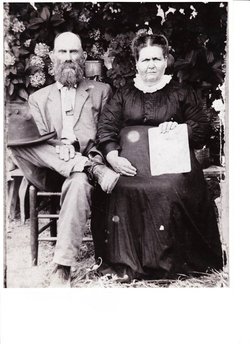
| Description | : | Batesburg, SC - Tandie "Tan" Miller, 62, died Tuesday, January 11, 1955 in an automobile accident on Highway 245 near Batesburg-Leesville. He was a sawmiller and farmer in the Sardis community. He was also a World War I veteran and a member of Nazareth Methodist Church near the Traffic Circle in Saluda County. He was the son of the late William and Perdida Rinehart Miller of Saluda County. He was married April 28, 1917, to the former Lillie Mae Sanford of Saluda County. Survivors include his wife, Lillie Mae Sanford Miller of Batesburg; six sons, Vernon, Ray,... Read More |
frequently asked questions (FAQ):
-
Where is Tandie “Tan” Miller's memorial?
Tandie “Tan” Miller's memorial is located at: Calvary Cemetery, Athol, Worcester County, USA.
-
When did Tandie “Tan” Miller death?
Tandie “Tan” Miller death on 11 Jan 1955 in Lexington County, South Carolina, USA
-
Where are the coordinates of the Tandie “Tan” Miller's memorial?
Latitude: 42.5842018
Longitude: -72.2117004
Family Members:
Parent
Spouse

Siblings
Children
Flowers:


Nearby Cemetories:
1. Calvary Cemetery
Athol, Worcester County, USA
Coordinate: 42.5842018, -72.2117004
2. Old Pleasant Street Cemetery
Athol, Worcester County, USA
Coordinate: 42.5860800, -72.2145100
3. Highland Cemetery
Athol, Worcester County, USA
Coordinate: 42.5889015, -72.2110977
4. Old Burial Ground
Athol, Worcester County, USA
Coordinate: 42.5889840, -72.2270420
5. Silver Lake Cemetery
Athol, Worcester County, USA
Coordinate: 42.6018982, -72.2249985
6. Ellinwood Cemetery
Athol, Worcester County, USA
Coordinate: 42.5589400, -72.2142600
7. Mount Pleasant Cemetery
Athol, Worcester County, USA
Coordinate: 42.5943985, -72.2433014
8. Gethsemane Cemetery
Athol, Worcester County, USA
Coordinate: 42.5791960, -72.2578310
9. Adams Road Cemetery
Athol, Worcester County, USA
Coordinate: 42.5425560, -72.2133610
10. Fay Cemetery
Athol, Worcester County, USA
Coordinate: 42.5466300, -72.2364200
11. Stratton Cemetery
Athol, Worcester County, USA
Coordinate: 42.5407872, -72.2151265
12. New Sherborn Cemetery
Athol, Worcester County, USA
Coordinate: 42.5402985, -72.2166977
13. Chestnut Hill Cemetery
Athol, Worcester County, USA
Coordinate: 42.6296997, -72.2042007
14. Jones Cemetery
Orange, Franklin County, USA
Coordinate: 42.6148224, -72.2728806
15. Harvard Cemetery
Petersham, Worcester County, USA
Coordinate: 42.5305000, -72.1896100
16. Lower Cemetery
Phillipston, Worcester County, USA
Coordinate: 42.5583000, -72.1425018
17. Tully Cemetery
Orange, Franklin County, USA
Coordinate: 42.6398000, -72.2504700
18. Northwest Cemetery
Petersham, Worcester County, USA
Coordinate: 42.5210991, -72.2268982
19. Upper Cemetery
Phillipston, Worcester County, USA
Coordinate: 42.5512820, -72.1339770
20. North Orange Cemetery
Orange, Franklin County, USA
Coordinate: 42.6360230, -72.2690530
21. Riverside Cemetery
Royalston, Worcester County, USA
Coordinate: 42.6302986, -72.1453018
22. Branch Bridge Cemetery
New Salem, Franklin County, USA
Coordinate: 42.5337500, -72.2743640
23. Central Cemetery
Orange, Franklin County, USA
Coordinate: 42.5932960, -72.3066420
24. South Cemetery
Orange, Franklin County, USA
Coordinate: 42.5657880, -72.3043410