

Terry Lee Alstrum
| Birth | : | 5 Nov 1946 Sacramento, Sacramento County, California, USA |
| Death | : | 25 Jun 2006 Sacramento, Sacramento County, California, USA |
| Burial | : | Galt Cemetery, Galt, Sacramento County, USA |
| Coordinate | : | 38.2414017, -121.3013992 |
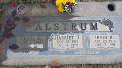
| Description | : | Terry Lee Alstrum (59) of Galt died suddenly on June 25, 2006 in a Sacramento hospital from natural causes. He was born on Nov. 5, 1946 in Sacramento and has lived in the Galt area since 1946. His parents, Irvin and Harriet Alstrum, preceded him in death. A chapel service was held at Ben Salas Funeral Home on Thursday, June 29, at 11 a.m. Committal followed at Galt Cemetery. |
frequently asked questions (FAQ):
-
Where is Terry Lee Alstrum's memorial?
Terry Lee Alstrum's memorial is located at: Galt Cemetery, Galt, Sacramento County, USA.
-
When did Terry Lee Alstrum death?
Terry Lee Alstrum death on 25 Jun 2006 in Sacramento, Sacramento County, California, USA
-
Where are the coordinates of the Terry Lee Alstrum's memorial?
Latitude: 38.2414017
Longitude: -121.3013992
Family Members:
Parent

Siblings
Flowers:


Nearby Cemetories:
1. Galt Cemetery
Galt, Sacramento County, USA
Coordinate: 38.2414017, -121.3013992
2. Liberty Cemetery
Acampo, San Joaquin County, USA
Coordinate: 38.2350006, -121.2782974
3. De Vries Ranch Family Cemetery
Lodi, San Joaquin County, USA
Coordinate: 38.2005530, -121.3556060
4. Hicksville Cemetery
Hicksville, Sacramento County, USA
Coordinate: 38.3257942, -121.3190765
5. Woodbridge Masonic Cemetery
Woodbridge, San Joaquin County, USA
Coordinate: 38.1496506, -121.3016663
6. Elliott Cemetery
San Joaquin County, USA
Coordinate: 38.2341995, -121.1761017
7. Fairbanks Ranch Cemetery
San Joaquin County, USA
Coordinate: 38.2310250, -121.1725170
8. Lodi Memorial Park and Cemetery
Lodi, San Joaquin County, USA
Coordinate: 38.1319008, -121.2455978
9. Saint John The Baptist Episcopal Columbarium
Lodi, San Joaquin County, USA
Coordinate: 38.1213500, -121.3074400
10. Locke Cemetery
Lockeford, San Joaquin County, USA
Coordinate: 38.1758003, -121.1616974
11. Harmony Grove Cemetery
Lockeford, San Joaquin County, USA
Coordinate: 38.1478004, -121.1755981
12. Saint Joachim Catholic Cemetery
Lockeford, San Joaquin County, USA
Coordinate: 38.1478400, -121.1752500
13. Islamic Cemetery of California
Lodi, San Joaquin County, USA
Coordinate: 38.1091730, -121.2563590
14. Cherokee Memorial Park
Lodi, San Joaquin County, USA
Coordinate: 38.1017303, -121.2585983
15. Live Oak Cemetery
Lodi, San Joaquin County, USA
Coordinate: 38.0868760, -121.2874780
16. Point Pleasant Cemetery
Point Pleasant, Sacramento County, USA
Coordinate: 38.3308525, -121.4638290
17. Old Mackville Cemetery
Clements, San Joaquin County, USA
Coordinate: 38.2143200, -121.0968300
18. Sharp Family Cemetery
Walnut Grove, Sacramento County, USA
Coordinate: 38.2351900, -121.5135800
19. Glen View Cemetery
Clements, San Joaquin County, USA
Coordinate: 38.2022018, -121.0883026
20. Hilltop Cemetery
Elk Grove, Sacramento County, USA
Coordinate: 38.4156490, -121.3534950
21. Elk Grove Cosumnes-Cemetery
Elk Grove, Sacramento County, USA
Coordinate: 38.4088593, -121.3875504
22. Franklin Cemetery
Franklin, Sacramento County, USA
Coordinate: 38.3761749, -121.4558029
23. Pleasant Grove Cemetery
Elk Grove, Sacramento County, USA
Coordinate: 38.4302220, -121.3107670
24. East Lawn Elk Grove Memorial Park
Elk Grove, Sacramento County, USA
Coordinate: 38.4282608, -121.3969955