
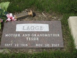
Tessie Mae Kovarik Lagge
| Birth | : | 22 Sep 1916 McLean County, North Dakota, USA |
| Death | : | 20 Nov 2017 Garrison, McLean County, North Dakota, USA |
| Burial | : | Garrison Cemetery, Garrison, McLean County, USA |
| Coordinate | : | 47.6650000, -101.4201000 |
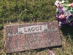
| Description | : | Tessie Mae (Kovarik) Lagge, 101 of Garrison, ND passed to her eternal home on November 20, 2017 at a nursing facility in Garrison, ND. Tessie was born to John and Myrtle (Turner) Kovarik on September 22, 1916 in Blackwater Township near Garrison. She attended school in the Emmet area. On November 19, 1936 she married her forever husband, Edwin Lagge and they settled in the Emmet area. They farmed and raised livestock in the Emmet area where they also raised their six children. Edwin passed away in July of 1974. Tessie continued to live on the farm where she did... Read More |
frequently asked questions (FAQ):
-
Where is Tessie Mae Kovarik Lagge's memorial?
Tessie Mae Kovarik Lagge's memorial is located at: Garrison Cemetery, Garrison, McLean County, USA.
-
When did Tessie Mae Kovarik Lagge death?
Tessie Mae Kovarik Lagge death on 20 Nov 2017 in Garrison, McLean County, North Dakota, USA
-
Where are the coordinates of the Tessie Mae Kovarik Lagge's memorial?
Latitude: 47.6650000
Longitude: -101.4201000
Family Members:
Parent
Spouse
Siblings

Children

Flowers:


Nearby Cemetories:
1. Garrison Cemetery
Garrison, McLean County, USA
Coordinate: 47.6650000, -101.4201000
2. Saint Nicholas Cemetery
Garrison, McLean County, USA
Coordinate: 47.6469210, -101.3976590
3. Kloestitz German Cemetery
McLean County, USA
Coordinate: 47.6739490, -101.3461250
4. Saint Pauls Cemetery
Garrison, McLean County, USA
Coordinate: 47.6570200, -101.3344940
5. Fort Stevenson Post Cemetery
McLean County, USA
Coordinate: 47.5758800, -101.4453500
6. Saint Pauls Lutheran Cemetery
Douglas Township, McLean County, USA
Coordinate: 47.7476349, -101.4856491
7. Endres Catholic Cemetery
Max, McLean County, USA
Coordinate: 47.7099075, -101.2397003
8. Zion Lutheran Cemetery
Max, McLean County, USA
Coordinate: 47.7653999, -101.2937622
9. Clifton Cemetery
McLean County, USA
Coordinate: 47.7317009, -101.6235962
10. Saint Peter Cemetery
Emmet, McLean County, USA
Coordinate: 47.6742020, -101.6510010
11. Geminde Cemetery
Mercer County, USA
Coordinate: 47.5172005, -101.5061035
12. Saint Johns Congregational Cemetery
Max, McLean County, USA
Coordinate: 47.6871730, -101.1750700
13. Max City Cemetery
Max, McLean County, USA
Coordinate: 47.8127100, -101.2935300
14. Miller Cemetery
Pick City, Mercer County, USA
Coordinate: 47.5018480, -101.5100250
15. Max City Cemetery Old
Max, McLean County, USA
Coordinate: 47.8268088, -101.3014727
16. Evangelical Lutheran Cemetery
Max, McLean County, USA
Coordinate: 47.8268000, -101.3000000
17. Saint Mathew Cemetery
Max, McLean County, USA
Coordinate: 47.7755740, -101.1972780
18. Trinity Mannhaven Cemetery
Pick City, Mercer County, USA
Coordinate: 47.4880260, -101.5064950
19. Immaculate Conception Cemetery
Max, McLean County, USA
Coordinate: 47.8177986, -101.2613983
20. Lilly Dale Cemetery
Emmet, McLean County, USA
Coordinate: 47.5887050, -101.6742500
21. First German Baptist Cemetery
Max, McLean County, USA
Coordinate: 47.6887283, -101.1341629
22. First Baptist Cemetery
Ward County, USA
Coordinate: 47.8484612, -101.2989349
23. Douglas City Cemetery
Douglas, Ward County, USA
Coordinate: 47.8610600, -101.4975100
24. Coleharbor Cemetery
Coleharbor, McLean County, USA
Coordinate: 47.5024986, -101.2369003