
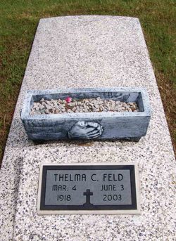
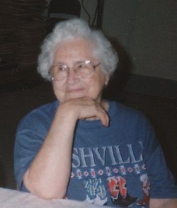

Thelma Cecilia O'Neill Feld
| Birth | : | 4 Mar 1918 Chanute, Neosho County, Kansas, USA |
| Death | : | 3 Jun 2003 Coffeyville, Montgomery County, Kansas, USA |
| Burial | : | Egg Harbor City Cemetery, Egg Harbor City, Atlantic County, USA |
| Coordinate | : | 39.5504799, -74.6369095 |
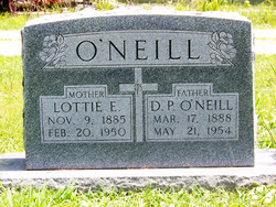
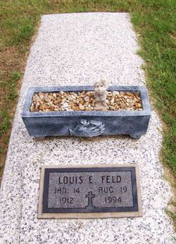
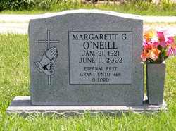
| Description | : | ******************************* Published Dec 30, 2004 - Chanute, KS Thelma Cecilia Feld, 85, of Chanute, Kansas passed away Tuesday, June 3, 2003 at Windsor Place in Coffeyville, Kansas. She was born on March 4, 1918, in Chanute, Kansas, the daughter of Dan P. O'Neill and Lottie (Rush) O'Neill. Thelma was raised and attended public schools in Chanute, and graduated from Chanute High School. She was united in marriage to Louis E. Feld on October 23, 1945 in Chanute, Kansas. He preceded her in death on August 19, 1994. Thelma worked at the Chanute Dress Factory, and in the Dietary Department at Neosho Memorial Regional... Read More |
frequently asked questions (FAQ):
-
Where is Thelma Cecilia O'Neill Feld's memorial?
Thelma Cecilia O'Neill Feld's memorial is located at: Egg Harbor City Cemetery, Egg Harbor City, Atlantic County, USA.
-
When did Thelma Cecilia O'Neill Feld death?
Thelma Cecilia O'Neill Feld death on 3 Jun 2003 in Coffeyville, Montgomery County, Kansas, USA
-
Where are the coordinates of the Thelma Cecilia O'Neill Feld's memorial?
Latitude: 39.5504799
Longitude: -74.6369095
Family Members:
Parent

Spouse
Siblings
Flowers:


Nearby Cemetories:
1. Egg Harbor City Cemetery
Egg Harbor City, Atlantic County, USA
Coordinate: 39.5504799, -74.6369095
2. Saint Nicholas Roman Catholic Church Cemetery
Egg Harbor City, Atlantic County, USA
Coordinate: 39.5318222, -74.6367950
3. Shaler Burial Ground
Egg Harbor City, Atlantic County, USA
Coordinate: 39.5593452, -74.6049881
4. Germania Cemetery
Germania, Atlantic County, USA
Coordinate: 39.5310707, -74.5867081
5. Laurel Hill Cemetery
Elwood, Atlantic County, USA
Coordinate: 39.5916519, -74.6949463
6. Elwood Rural Cemetery
Elwood, Atlantic County, USA
Coordinate: 39.5817184, -74.7122574
7. Green Bank Methodist Cemetery
Green Bank, Burlington County, USA
Coordinate: 39.6095276, -74.5847397
8. Charles Williams Burial Site
Elwood, Atlantic County, USA
Coordinate: 39.5864530, -74.7179570
9. Clark Burial Site
Clarks Landing, Atlantic County, USA
Coordinate: 39.5760080, -74.5442020
10. Adams Burying Ground
Lower Bank, Burlington County, USA
Coordinate: 39.5903400, -74.5460800
11. Johnson Cemetery
Lower Bank, Burlington County, USA
Coordinate: 39.5902405, -74.5458755
12. Cavileer-Sooy Memorial Site
Lower Bank, Burlington County, USA
Coordinate: 39.5942268, -74.5479355
13. Lower Bank Cemetery
Lower Bank, Burlington County, USA
Coordinate: 39.6081085, -74.5572052
14. Saint Marys of the Assumption Cemetery
Pleasant Mills, Atlantic County, USA
Coordinate: 39.6346092, -74.6601715
15. Joseph Mulliner Gravesite
Pleasant Mills, Atlantic County, USA
Coordinate: 39.6377830, -74.6564670
16. Batsto-Pleasant Mills Cemetery
Pleasant Mills, Atlantic County, USA
Coordinate: 39.6406898, -74.6605606
17. Laurel Memorial Park and Crematory
Egg Harbor Township, Atlantic County, USA
Coordinate: 39.4565887, -74.5941925
18. Carmantown Cemetery
Carmantown, Atlantic County, USA
Coordinate: 39.4483250, -74.6446000
19. Clarks Mill Burying Ground
Port Republic, Atlantic County, USA
Coordinate: 39.5180817, -74.5098877
20. Boling Cemetery
Port Republic, Atlantic County, USA
Coordinate: 39.5084000, -74.5123978
21. Holy Cross Cemetery and Chapel Mausoleum
Mays Landing, Atlantic County, USA
Coordinate: 39.4490395, -74.6839523
22. Lincoln Memorial Park
Mays Landing, Atlantic County, USA
Coordinate: 39.4478493, -74.6872635
23. Saint Paul's Methodist Episcopal Church Cemetery
Port Republic, Atlantic County, USA
Coordinate: 39.5194400, -74.4951000
24. Methodist Union Chapel Cemetery
Port Republic, Atlantic County, USA
Coordinate: 39.5185089, -74.4952316