

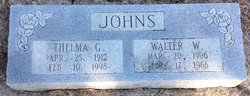
Thelma Gwynn Johns
| Birth | : | 25 Apr 1912 Louisville, Jefferson County, Kentucky, USA |
| Death | : | 10 Feb 1998 Concordia, Cloud County, Kansas, USA |
| Burial | : | Hollis Cemetery, Cloud County, USA |
| Coordinate | : | 39.6383018, -97.5361023 |
| Plot | : | C/8 |
| Description | : | Thelma G. Johns, 85, died Tuesday at Beverly Health and Rehabilitation, Concordia, KS. Mrs. Johns was born Thelma G. Gwynn on April 25, 1912, at Louisville, KY, and was a resident of Junction City, KS, before moving to Concordia. She was a member of the First United Methodist Church, Junction City. Her husband, Walter W. Johns, died in 1966. Survivors include a sister, Alberta Taunton of Emporia and a nephew. Services were held at Hollis Cemetery with Rev. Bill Eisele officiating. 1915 Kansas Census, she and her mother are living in Junction City with paternal grandparents,... Read More |
frequently asked questions (FAQ):
-
Where is Thelma Gwynn Johns's memorial?
Thelma Gwynn Johns's memorial is located at: Hollis Cemetery, Cloud County, USA.
-
When did Thelma Gwynn Johns death?
Thelma Gwynn Johns death on 10 Feb 1998 in Concordia, Cloud County, Kansas, USA
-
Where are the coordinates of the Thelma Gwynn Johns's memorial?
Latitude: 39.6383018
Longitude: -97.5361023
Family Members:
Flowers:


Nearby Cemetories:
1. Hollis Cemetery
Cloud County, USA
Coordinate: 39.6383018, -97.5361023
2. Zion Cemetery
Agenda, Republic County, USA
Coordinate: 39.6749992, -97.5939026
3. Beck Family Cemetery
Agenda, Republic County, USA
Coordinate: 39.6818000, -97.4863000
4. Union Cemetery
Wayne, Republic County, USA
Coordinate: 39.6977997, -97.5457993
5. Gotland Cemetery
Sibley Township, Cloud County, USA
Coordinate: 39.6091995, -97.6125031
6. Minersville Cemetery
Talmo, Republic County, USA
Coordinate: 39.6568330, -97.6229250
7. Walnut Grove Cemetery
Cloud County, USA
Coordinate: 39.5699997, -97.4993973
8. Rose Hill Cemetery
Wayne, Republic County, USA
Coordinate: 39.7111015, -97.5661011
9. Rice Cemetery
Rice, Cloud County, USA
Coordinate: 39.5614014, -97.5552979
10. Agenda Cemetery
Agenda, Republic County, USA
Coordinate: 39.6761017, -97.4336014
11. Murdock Family Cemetery
Cloud County, USA
Coordinate: 39.6386400, -97.6504800
12. Saron Lutheran Cemetery
Sibley Township, Cloud County, USA
Coordinate: 39.6385994, -97.6511002
13. Mount Hope Cemetery
Clyde, Cloud County, USA
Coordinate: 39.5969009, -97.4116974
14. Mount Calvary Cemetery
Clyde, Cloud County, USA
Coordinate: 39.5917015, -97.4143982
15. Frontier Cemetery
Belleville, Republic County, USA
Coordinate: 39.7400017, -97.5986023
16. Nelson Cemetery
Rice, Cloud County, USA
Coordinate: 39.5257988, -97.5410995
17. Green Mound Cemetery
Rice, Cloud County, USA
Coordinate: 39.5248450, -97.5081630
18. West Creek Cemetery
Belleville, Republic County, USA
Coordinate: 39.7041660, -97.6608930
19. Saint Concordia Cemetery
Concordia, Cloud County, USA
Coordinate: 39.5593800, -97.6503100
20. Sibley Cemetery
Sibley Township, Cloud County, USA
Coordinate: 39.6096992, -97.6908035
21. Nazareth Convent Cemetery
Concordia, Cloud County, USA
Coordinate: 39.5614000, -97.6612000
22. Pleasant View Cemetery
Ames, Cloud County, USA
Coordinate: 39.5346985, -97.4431000
23. Pleasant Hill Cemetery
Concordia, Cloud County, USA
Coordinate: 39.5583000, -97.6639023
24. Nelson Family Cemetery
Sibley Township, Cloud County, USA
Coordinate: 39.6366600, -97.7010600