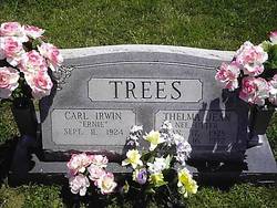
Thelma Jean Utter Trees
| Birth | : | 17 Jan 1928 Mount Washington, Hamilton County, Ohio, USA |
| Death | : | 16 Jul 1992 Cincinnati, Hamilton County, Ohio, USA |
| Burial | : | Bedel Cemetery, Bath, Grafton County, USA |
| Coordinate | : | 44.2075000, -72.0455560 |
frequently asked questions (FAQ):
-
Where is Thelma Jean Utter Trees's memorial?
Thelma Jean Utter Trees's memorial is located at: Bedel Cemetery, Bath, Grafton County, USA.
-
When did Thelma Jean Utter Trees death?
Thelma Jean Utter Trees death on 16 Jul 1992 in Cincinnati, Hamilton County, Ohio, USA
-
Where are the coordinates of the Thelma Jean Utter Trees's memorial?
Latitude: 44.2075000
Longitude: -72.0455560
Family Members:
Parent
Spouse
Siblings
Flowers:
Nearby Cemetories:
1. Bedel Cemetery
Bath, Grafton County, USA
Coordinate: 44.2075000, -72.0455560
2. Carbee District Cemetery
Bath, Grafton County, USA
Coordinate: 44.1881040, -72.0521310
3. Manchester Family Cemetery
Ryegate, Caledonia County, USA
Coordinate: 44.2153625, -72.0713120
4. Saint Joseph Cemetery
Bath, Grafton County, USA
Coordinate: 44.1803017, -72.0524979
5. Upper Smith Road Cemetery
Bath, Grafton County, USA
Coordinate: 44.2202780, -72.0075000
6. Carbee Cemetery
Bath, Grafton County, USA
Coordinate: 44.1724640, -72.0466980
7. Old Scotch Cemetery
Ryegate, Caledonia County, USA
Coordinate: 44.1969000, -72.0928600
8. Blue Mountain Cemetery
Ryegate Corner, Caledonia County, USA
Coordinate: 44.2081000, -72.1058700
9. Monroe Village Cemetery
Monroe, Grafton County, USA
Coordinate: 44.2558400, -72.0427900
10. West Bath Cemetery
Bath, Grafton County, USA
Coordinate: 44.1750930, -71.9865080
11. Wells River Cemetery
Wells River, Orange County, USA
Coordinate: 44.1535988, -72.0547028
12. Moulton Hill Cemetery
Lyman, Grafton County, USA
Coordinate: 44.2457400, -71.9862900
13. Boltonville Cemetery
Boltonville, Orange County, USA
Coordinate: 44.1575012, -72.0877991
14. Pettyboro District Cemetery
Pettyboro, Grafton County, USA
Coordinate: 44.2038310, -71.9620880
15. Pinehurst Cemetery
Ryegate, Caledonia County, USA
Coordinate: 44.1856003, -72.1280975
16. McIndoe Falls Cemetery
Barnet, Caledonia County, USA
Coordinate: 44.2685400, -72.0724900
17. Hillside Cemetery
South Ryegate, Caledonia County, USA
Coordinate: 44.1846800, -72.1336200
18. Bath Village Cemetery
Bath, Grafton County, USA
Coordinate: 44.1693500, -71.9617800
19. Pine Grove Cemetery
Woodsville, Grafton County, USA
Coordinate: 44.1380997, -72.0188980
20. Jefferson Hill Cemetery
Newbury, Orange County, USA
Coordinate: 44.1658400, -72.1424200
21. Hall-West Cemetery
Ryegate, Caledonia County, USA
Coordinate: 44.2306085, -72.1600941
22. Parker Hill Cemetery
Lyman, Grafton County, USA
Coordinate: 44.2582400, -71.9458800
23. Stevens Cemetery
Barnet, Caledonia County, USA
Coordinate: 44.2976700, -72.0481100
24. Pleasant View Cemetery
Barnet, Caledonia County, USA
Coordinate: 44.2980200, -72.0469500

