

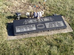
Theodore R. “Ted” Gray
| Birth | : | 20 Oct 1912 Mount Pleasant, Henry County, Iowa, USA |
| Death | : | 16 Jan 2011 Danville, Des Moines County, Iowa, USA |
| Burial | : | Holy Cross Cemetery, Spring Mills, Centre County, USA |
| Coordinate | : | 40.8415000, -77.5706000 |
| Description | : | Theodore Gray . Theodore R. "Ted" Gray, 98, of Danville died Sunday, Jan. 16, 2011, at Danville Care Center. Born Oct. 20, 1912, in Mount Pleasant, he was the son of Claude and Anna Rudd Gray. On March 31, 1936, he married Fern Anna Johnson in Mount Pleasant. She died May 20, 2007. Mr. Gray farmed in Mount Pleasant, New London and north of Danville and owned and operated with his wife Gray's Service Center in Fort Madison. He attended Mount Pleasant Schools. He was of the Christian faith. He was a member of Eagles in Burlington, Roaming Hawks and Traveling Tigers camping clubs, Circle... Read More |
frequently asked questions (FAQ):
-
Where is Theodore R. “Ted” Gray's memorial?
Theodore R. “Ted” Gray's memorial is located at: Holy Cross Cemetery, Spring Mills, Centre County, USA.
-
When did Theodore R. “Ted” Gray death?
Theodore R. “Ted” Gray death on 16 Jan 2011 in Danville, Des Moines County, Iowa, USA
-
Where are the coordinates of the Theodore R. “Ted” Gray's memorial?
Latitude: 40.8415000
Longitude: -77.5706000
Family Members:
Parent

Spouse
Siblings
Children
Flowers:


Nearby Cemetories:
1. Holy Cross Cemetery
Spring Mills, Centre County, USA
Coordinate: 40.8415000, -77.5706000
2. Spring Mills Cemetery
Spring Mills, Centre County, USA
Coordinate: 40.8564760, -77.5798890
3. Allison Cemetery
Spring Mills, Centre County, USA
Coordinate: 40.8697730, -77.5745072
4. East Penns Valley Presbyterian Cemetery
Gregg Township, Centre County, USA
Coordinate: 40.8670250, -77.5518220
5. Heckman Cemetery
Spring Mills, Centre County, USA
Coordinate: 40.8639000, -77.5369000
6. Mountain Cemetery
Spring Mills, Centre County, USA
Coordinate: 40.8147011, -77.5417023
7. Green Grove Cemetery
Centre County, USA
Coordinate: 40.8788000, -77.5453000
8. Salem United Church Of Christ Cemetery
Spring Mills, Centre County, USA
Coordinate: 40.8745000, -77.5350000
9. Egg Hill Cemetery
Centre County, USA
Coordinate: 40.8284000, -77.6250000
10. Saint Johns Union Cemetery
Farmers Mills, Centre County, USA
Coordinate: 40.8699989, -77.6185989
11. Sprucetown Cemetery
Centre County, USA
Coordinate: 40.8090000, -77.6272000
12. Amish Cemetery
Gregg Township, Centre County, USA
Coordinate: 40.8952710, -77.5782170
13. Paradise Cemetery
Centre County, USA
Coordinate: 40.8563995, -77.5017014
14. Indian Lane Grave
Old Fort, Centre County, USA
Coordinate: 40.8402000, -77.6469000
15. Centre Hill Presbyterian Cemetery
Potters Mills, Centre County, USA
Coordinate: 40.8182300, -77.6469500
16. Huston Cemetery
Centre Hall, Centre County, USA
Coordinate: 40.8586430, -77.6498740
17. Yearick Cemetery
Madisonburg, Centre County, USA
Coordinate: 40.9068150, -77.5644420
18. Valley Mennonite Church Cemetery
Madisonburg, Centre County, USA
Coordinate: 40.9088750, -77.5582190
19. Fairview Cemetery
Millheim, Centre County, USA
Coordinate: 40.8875008, -77.4867020
20. Union Cemetery
Millheim, Centre County, USA
Coordinate: 40.8894005, -77.4839020
21. Pennington Cemetery
Centre Hall, Centre County, USA
Coordinate: 40.8562820, -77.6778240
22. Reichard Cemetery
Millheim, Centre County, USA
Coordinate: 40.8915454, -77.4795903
23. Reformed and Lutheran Cemetery
Centre Hall, Centre County, USA
Coordinate: 40.8462410, -77.6895828
24. Emmanuel Union Cemetery
Tusseyville, Centre County, USA
Coordinate: 40.7987000, -77.6778000