

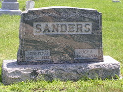
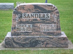
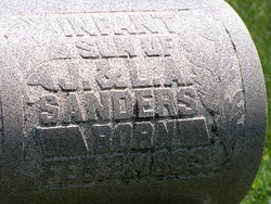
Thomas Davis Sanders
| Birth | : | 20 Oct 1883 Miami County, Indiana, USA |
| Death | : | 24 Oct 1949 Fulton County, Indiana, USA |
| Burial | : | Washington Cemetery, Duncombe, Webster County, USA |
| Coordinate | : | 42.4277992, -93.9916992 |
| Plot | : | Section 10, Row 4 |
| Description | : | Published in the Rochester News-Sentinel, Monday, October 24, 1949 Thomas D. SANDERS, 66, committed suicide at 7 a.m. today by shooting himself in the head with a shot gun. He was found in the bath room of his farm home, five miles southeast of Rochester, near Green Oak about 20 minutes later by his daughter, Mrs. Betty RENTSCHLER, Fulton. According to reports, Sanders called Mrs. Rentschler earlier in the morning saying that he wanted "to talk to her." The suicide was attributed to despondency. Born Oct. 20, 1883 in Miami county, he resided in the Green Oak community his... Read More |
frequently asked questions (FAQ):
-
Where is Thomas Davis Sanders's memorial?
Thomas Davis Sanders's memorial is located at: Washington Cemetery, Duncombe, Webster County, USA.
-
When did Thomas Davis Sanders death?
Thomas Davis Sanders death on 24 Oct 1949 in Fulton County, Indiana, USA
-
Where are the coordinates of the Thomas Davis Sanders's memorial?
Latitude: 42.4277992
Longitude: -93.9916992
Family Members:
Parent

Spouse
Siblings
Children
Flowers:


Nearby Cemetories:
1. Washington Cemetery
Duncombe, Webster County, USA
Coordinate: 42.4277992, -93.9916992
2. Blanchard Cemetery
Webster County, USA
Coordinate: 42.4021988, -93.9997025
3. Washington Township Cemetery
Duncombe, Webster County, USA
Coordinate: 42.4707900, -94.0002000
4. Ober and Scott Cemetery
Duncombe, Webster County, USA
Coordinate: 42.3841390, -93.9982856
5. Saint Josephs Cemetery
Duncombe, Webster County, USA
Coordinate: 42.4789009, -93.9922028
6. Border Plains Cemetery
Border Plains, Webster County, USA
Coordinate: 42.3917000, -94.0448000
7. Hartman Cemetery
Lehigh, Webster County, USA
Coordinate: 42.3666397, -93.9835627
8. Holaday Creek Cemetery
Webster County, USA
Coordinate: 42.4472008, -94.0886002
9. Homer Cemetery
Homer, Hamilton County, USA
Coordinate: 42.3680992, -93.9088974
10. West Lawn Cemetery
Lehigh, Webster County, USA
Coordinate: 42.3616982, -94.0678024
11. McGuire Bend Cemetery
Dayton, Webster County, USA
Coordinate: 42.3410000, -93.9880000
12. Oak Grove Cemetery
Lehigh, Webster County, USA
Coordinate: 42.3438988, -94.0475006
13. Otho Cemetery
Otho, Webster County, USA
Coordinate: 42.4025002, -94.1153030
14. Colfax Cemetery
Webster County, USA
Coordinate: 42.5224991, -94.0194016
15. Vegors Cemetery
Webster County, USA
Coordinate: 42.3177986, -93.9421997
16. Community Church Cemetery
Kamrar, Hamilton County, USA
Coordinate: 42.4556000, -93.8342000
17. Calvary Cemetery
Webster City, Hamilton County, USA
Coordinate: 42.4556007, -93.8341980
18. Graceland Cemetery
Webster City, Hamilton County, USA
Coordinate: 42.4578018, -93.8308029
19. Neese Cemetery
Homer, Hamilton County, USA
Coordinate: 42.3250000, -93.8935000
20. Nesse Cemetery
Hamilton County, USA
Coordinate: 42.3250008, -93.8933029
21. Bass Cemetery
Dayton, Webster County, USA
Coordinate: 42.2966995, -94.0149994
22. Trails End Cemetery
Webster City, Hamilton County, USA
Coordinate: 42.4587810, -93.8128710
23. Fort Dodge Memorial Park
Fort Dodge, Webster County, USA
Coordinate: 42.5032997, -94.1472015
24. Hooks Point Cemetery
Hamilton County, USA
Coordinate: 42.2944530, -93.9199090