
| Birth | : | 3 May 1900 Effingham, Atchison County, Kansas, USA |
| Death | : | 14 Aug 1972 Holton, Jackson County, Kansas, USA |
| Burial | : | Norwich Village Cemetery, Norwich, Oxford County Municipality, Canada |
| Coordinate | : | 42.9840000, -80.6041800 |
| Plot | : | Farrar Block 5 Lot 17 |
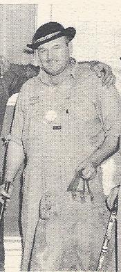
| Description | : | Topeka State Journal 15 Tuesday 1972, p 23 VALLEY FALLS - Thomas Earnest "Tom" Christie, 72, was dead on arrival at a Holton hospital Monday after he had an apparent heart attack at his home here. He was born May 3, 1900 near Effingham, and spent his early life in the Muscotah community. He lived in the Peters Creek community west of Valley Falls 20 years before he moved into Valley Falls in 1970. He was a retired farmer. He was a member of the Christian Church and the Valley Falls Saddle Club. He was married... Read More |
frequently asked questions (FAQ):
-
Where is Thomas Earnest “Tom” Christie's memorial?
Thomas Earnest “Tom” Christie's memorial is located at: Norwich Village Cemetery, Norwich, Oxford County Municipality, Canada.
-
When did Thomas Earnest “Tom” Christie death?
Thomas Earnest “Tom” Christie death on 14 Aug 1972 in Holton, Jackson County, Kansas, USA
-
Where are the coordinates of the Thomas Earnest “Tom” Christie's memorial?
Latitude: 42.9840000
Longitude: -80.6041800
Family Members:
Parent
Spouse

Siblings
Children
Flowers:


Nearby Cemetories:
1. Norwich Village Cemetery
Norwich, Oxford County Municipality, Canada
Coordinate: 42.9840000, -80.6041800
2. North Norwich Pioneer Cemetery
Norwich, Oxford County Municipality, Canada
Coordinate: 43.0016975, -80.6069489
3. Quaker Street Friends Cemetery
Norwich, Oxford County Municipality, Canada
Coordinate: 43.0001900, -80.6155300
4. Norwich Gore Cemetery
Norwich, Oxford County Municipality, Canada
Coordinate: 42.9999400, -80.5564000
5. Milldale Burial Grounds
Milldale, Oxford County Municipality, Canada
Coordinate: 42.9452515, -80.5852966
6. African Methodist Episcopal Cemetery
Otterville, Oxford County Municipality, Canada
Coordinate: 42.9313940, -80.6082310
7. St. John's Anglican Cemetery
Oxford County Municipality, Canada
Coordinate: 42.9290830, -80.6072860
8. Otterville Cemetery
Otterville, Oxford County Municipality, Canada
Coordinate: 42.9285800, -80.6073870
9. Burgessville Baptist Cemetery
Burgessville, Oxford County Municipality, Canada
Coordinate: 43.0223500, -80.6601600
10. Pine Street Burying Ground
Otterville, Oxford County Municipality, Canada
Coordinate: 42.9235458, -80.6128235
11. Newark District Community Cemetery
Newark, Oxford County Municipality, Canada
Coordinate: 42.9701580, -80.6853440
12. Erbtown Cemetery
Otterville, Oxford County Municipality, Canada
Coordinate: 42.9232445, -80.6193924
13. New Durham Cemetery
Oxford County Municipality, Canada
Coordinate: 43.0418091, -80.5674210
14. Springford Community Cemetery
Springford, Oxford County Municipality, Canada
Coordinate: 42.9207090, -80.6433210
15. Hatchley Cemetery
Hatchley, Brant County Municipality, Canada
Coordinate: 43.0247000, -80.5253000
16. Summerville Cemetery
Oxford County Municipality, Canada
Coordinate: 42.9071410, -80.5751040
17. St. Peter's Roman Cathlolic Cemetery
Norwich, Oxford County Municipality, Canada
Coordinate: 42.9566270, -80.7072350
18. Bookton Cemetery
Bookton, Norfolk County, Canada
Coordinate: 42.9458700, -80.5059800
19. White Cemetery
Harley, Brant County Municipality, Canada
Coordinate: 43.0494000, -80.5377000
20. Zion Oriel Cemetery
Oriel, Oxford County Municipality, Canada
Coordinate: 43.0650630, -80.6425670
21. Northfield Cemetery
Northfield, Brant County Municipality, Canada
Coordinate: 43.0303600, -80.4847900
22. Kelvin United Cemetery
Kelvin, Norfolk County, Canada
Coordinate: 42.9974900, -80.4591900
23. Hill Free Methodist Cemetery
Burford, Brant County Municipality, Canada
Coordinate: 43.0044851, -80.4600627
24. Kelvin Cemetery
Burford, Brant County Municipality, Canada
Coordinate: 43.0005280, -80.4587240