
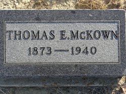
Thomas Elbert McKown
| Birth | : | 22 Feb 1873 Clarinda, Page County, Iowa, USA |
| Death | : | 27 Jan 1940 Havre, Hill County, Montana, USA |
| Burial | : | Gildford Hill County Cemetery, Gildford, Hill County, USA |
| Coordinate | : | 48.5778008, -110.2957993 |
| Plot | : | Block: 6; Lot: 16; Space: D |
| Description | : | Havre Daily News (MT), 30 Jan 1940 Gildford Man's Rites Wednesday Thomas E. McKown, 66, of Gildford, passed away at a Havre hospital at 10 p.m. Saturday. He will be buried at 2 p.m. Wednesday, from the Baptist church at Gildford. Thomas E. McKown was born Feb. 22, 1873, in Clarinda, Iowa, his parents being William and Sarah (Wooderson) McKown. He was married at Tekamah, Neb., Feb. 16, 1899. He came in 1910 to Hill County, homesteading four and a half miles south of Gildford, coming from Alberta, Canada, and has lived ever since on the homestead. McKown is... Read More |
frequently asked questions (FAQ):
-
Where is Thomas Elbert McKown's memorial?
Thomas Elbert McKown's memorial is located at: Gildford Hill County Cemetery, Gildford, Hill County, USA.
-
When did Thomas Elbert McKown death?
Thomas Elbert McKown death on 27 Jan 1940 in Havre, Hill County, Montana, USA
-
Where are the coordinates of the Thomas Elbert McKown's memorial?
Latitude: 48.5778008
Longitude: -110.2957993
Family Members:
Parent
Spouse
Siblings

Children
Flowers:


Nearby Cemetories:
1. Gildford Hill County Cemetery
Gildford, Hill County, USA
Coordinate: 48.5778008, -110.2957993
2. Hingham Union Cemetery
Hingham, Hill County, USA
Coordinate: 48.5601570, -110.4178980
3. Milk River Valley Church Graveyard
Hill County, USA
Coordinate: 48.6787180, -110.2261080
4. Cottonwood Lutheran Church Cemetery
Havre, Hill County, USA
Coordinate: 48.4545000, -110.1748000
5. Rudyard Cemetery
Rudyard, Hill County, USA
Coordinate: 48.5659500, -110.5390000
6. Bethel Cemetery
Hill County, USA
Coordinate: 48.6685982, -110.6406021
7. Inverness Cemetery
Hill County, USA
Coordinate: 48.5531340, -110.6688450
8. Cool Spring Colony Cemetery
Rudyard, Hill County, USA
Coordinate: 48.7704000, -110.5860000
9. Saint Johns Catholic Cemetery
Havre, Hill County, USA
Coordinate: 48.7625008, -109.9638977
10. Grainbelt Cemetery
Hill County, USA
Coordinate: 48.6828003, -109.8657990
11. Joplin Cemetery
Joplin, Liberty County, USA
Coordinate: 48.5576720, -110.7622930
12. Box Elder Cemetery
Box Elder, Hill County, USA
Coordinate: 48.3274000, -110.0095000
13. Sunset Garden Park
Havre, Hill County, USA
Coordinate: 48.5531006, -109.8019028
14. Grace Church Cemetery
Rudyard, Hill County, USA
Coordinate: 48.8269930, -110.6209890
15. Spring Coulee Cemetery
Hill County, USA
Coordinate: 48.9138985, -110.2035980
16. Saint Wenceslaus Cemetery
Goldstone, Hill County, USA
Coordinate: 48.9002610, -110.5310160
17. Kenilworth Cemetery
Chouteau County, USA
Coordinate: 48.2192001, -110.4188995
18. Mount Hope Cemetery
Havre, Hill County, USA
Coordinate: 48.5540000, -109.7050000
19. Highland Cemetery
Havre, Hill County, USA
Coordinate: 48.5463982, -109.6900024
20. Hilldale Hutterite Colony Cemetery
Hilldale Colony, Hill County, USA
Coordinate: 48.7997000, -109.7872000
21. Calvary Cemetery
Havre, Hill County, USA
Coordinate: 48.5457000, -109.6883000
22. North Havre Lutheran Church Graveyard (Defunct)
Havre, Hill County, USA
Coordinate: 48.6538903, -109.6815870
23. Big Sandy Cemetery
Big Sandy, Chouteau County, USA
Coordinate: 48.1801170, -110.1207500
24. Chester Cemetery
Chester, Liberty County, USA
Coordinate: 48.5219002, -110.9807968