
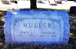
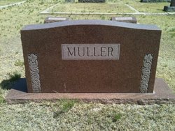
Thomas Leander “Armor” Muller
| Birth | : | May 1872 Clarinda, Page County, Iowa, USA |
| Death | : | 1960 Wray, Yuma County, Colorado, USA |
| Burial | : | St Cuthbert Churchyard, East Rainton, Metropolitan Borough of Sunderland, England |
| Coordinate | : | 54.8236030, -1.4790640 |
| Description | : | obit Thursday, Jan 14, 1960 "Wray Gazette", Wray, Colorado Armor Leander Muller, a widely known resident of Wray for a number of years, died Sunday at the Cedardale Nursing Home, where he had been a patient for the past three years and he had been in failing health due to his advanced age for this period. He was born May 23, 1872 at Clarinda, Iowa, and was 87 years, 8 months, and 17 days old at the time of his death. The funeral service was held Tuesday afternoon at the Christian Church in Wray with the Rev. G. Arland... Read More |
frequently asked questions (FAQ):
-
Where is Thomas Leander “Armor” Muller's memorial?
Thomas Leander “Armor” Muller's memorial is located at: St Cuthbert Churchyard, East Rainton, Metropolitan Borough of Sunderland, England.
-
When did Thomas Leander “Armor” Muller death?
Thomas Leander “Armor” Muller death on 1960 in Wray, Yuma County, Colorado, USA
-
Where are the coordinates of the Thomas Leander “Armor” Muller's memorial?
Latitude: 54.8236030
Longitude: -1.4790640
Family Members:
Spouse

Children

Flowers:


Nearby Cemetories:
1. St Cuthbert Churchyard
East Rainton, Metropolitan Borough of Sunderland, England
Coordinate: 54.8236030, -1.4790640
2. Houghton Cemetery
Houghton-le-Spring, Metropolitan Borough of Sunderland, England
Coordinate: 54.8347588, -1.4718029
3. St. Michael's RC Cemetery
Houghton-le-Spring, Metropolitan Borough of Sunderland, England
Coordinate: 54.8364300, -1.4714100
4. Hetton Cemetery
Hetton-le-Hole, Metropolitan Borough of Sunderland, England
Coordinate: 54.8256830, -1.4551984
5. St. Nicholas Churchyard
Hetton-le-Hole, Metropolitan Borough of Sunderland, England
Coordinate: 54.8201690, -1.4518480
6. St Michael & All Angels Churchyard
Houghton-le-Spring, Metropolitan Borough of Sunderland, England
Coordinate: 54.8421730, -1.4688210
7. Lyons St Michael & All Angels Churchyard
Houghton-le-Spring, Metropolitan Borough of Sunderland, England
Coordinate: 54.8423530, -1.4691540
8. Houghton Hillside Cemetery
Houghton-le-Spring, Metropolitan Borough of Sunderland, England
Coordinate: 54.8474737, -1.4641516
9. Easington Lane Cemetery
Easington Lane, Metropolitan Borough of Sunderland, England
Coordinate: 54.8103877, -1.4295255
10. St. Matthews Churchyard
Newbottle, Metropolitan Borough of Sunderland, England
Coordinate: 54.8575650, -1.4719100
11. Finchale Priory
Great Lumley, Durham Unitary Authority, England
Coordinate: 54.8181120, -1.5403970
12. St Laurence Churchyard
Pittington, Durham Unitary Authority, England
Coordinate: 54.7859220, -1.4907670
13. Great Lumley Cemetery
Great Lumley, Durham Unitary Authority, England
Coordinate: 54.8362470, -1.5421175
14. Christchurch Churchyard
Great Lumley, Durham Unitary Authority, England
Coordinate: 54.8370890, -1.5417950
15. St. Barnabas Churchyard
Bournmoor, Durham Unitary Authority, England
Coordinate: 54.8571260, -1.5195110
16. Holy Trinity Churchyard
South Hetton, Durham Unitary Authority, England
Coordinate: 54.8006610, -1.4135640
17. Belmont Cemetery
Belmont, Durham Unitary Authority, England
Coordinate: 54.7869300, -1.5244800
18. St Aidan Churchyard
New Herrington, Metropolitan Borough of Sunderland, England
Coordinate: 54.8693700, -1.4680430
19. St. Mary Magdalene Churchyard
Belmont, Durham Unitary Authority, England
Coordinate: 54.7863510, -1.5292050
20. St Cuthbert's Churchyard
New Herrington, Metropolitan Borough of Sunderland, England
Coordinate: 54.8708720, -1.4579010
21. Murton Cemetery
Murton, Durham Unitary Authority, England
Coordinate: 54.8153330, -1.3916320
22. Holy Trinity Churchyard
Murton, Durham Unitary Authority, England
Coordinate: 54.8159880, -1.3899430
23. St. Mary the Virgin Churchyard
Sherburn, Durham Unitary Authority, England
Coordinate: 54.7744380, -1.5086620
24. St Joseph's Roman Catholic Churchyard
Murton, Durham Unitary Authority, England
Coordinate: 54.8155960, -1.3888230