
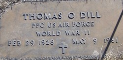

Thomas Oma Dill Sr.
| Birth | : | 29 Feb 1928 Ansley, Custer County, Nebraska, USA |
| Death | : | 9 May 1981 Los Banos, Merced County, California, USA |
| Burial | : | St. Peter and St. Paul Churchyard, Caistor, West Lindsey District, England |
| Coordinate | : | 53.4963400, -0.3179900 |
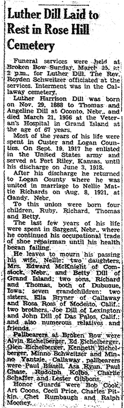
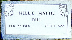
| Description | : | Thomas was a son of Luther Harrison Dill (1888-1956) & Nellie Mattie Richards (1907-1988). Thomas married Elizabeth Ethel Mars (1931-2000) on October 29, 1950 in Calloway, Custer Co., Nebraska. They had two identified children. Marriage ended in divorce. Thomas then married Ettie Omaha Wood (1932-2011) on May 3, 1955 in Hughes County, South Dakota. They had four identified children. Marriage ended in divorce. They remarried on May 23, 1959 in Dubuque County, Iowa. They had sIX identified children. Marriage ended in divorce. Thomas was a U.S. Air Force veteran of World War II. |
frequently asked questions (FAQ):
-
Where is Thomas Oma Dill Sr.'s memorial?
Thomas Oma Dill Sr.'s memorial is located at: St. Peter and St. Paul Churchyard, Caistor, West Lindsey District, England.
-
When did Thomas Oma Dill Sr. death?
Thomas Oma Dill Sr. death on 9 May 1981 in Los Banos, Merced County, California, USA
-
Where are the coordinates of the Thomas Oma Dill Sr.'s memorial?
Latitude: 53.4963400
Longitude: -0.3179900
Family Members:
Parent
Spouse
Siblings
Children

Flowers:


Nearby Cemetories:
1. St. Peter and St. Paul Churchyard
Caistor, West Lindsey District, England
Coordinate: 53.4963400, -0.3179900
2. Caistor Congregational Chapelyard
Caistor, West Lindsey District, England
Coordinate: 53.4971540, -0.3181850
3. Caistor Cemetery
Caistor, West Lindsey District, England
Coordinate: 53.4968870, -0.3299210
4. St John The Baptist Churchyard
Nettleton, West Lindsey District, England
Coordinate: 53.4867340, -0.3269800
5. St Nicholas Churchyard
Cabourne, West Lindsey District, England
Coordinate: 53.5015800, -0.2830600
6. All Hallows Churchyard
Clixby, West Lindsey District, England
Coordinate: 53.5233610, -0.3384560
7. St Mary Magdalene Churchyard
Rothwell, West Lindsey District, England
Coordinate: 53.4783820, -0.2693190
8. Grasby Church Burial Ground
Grasby, West Lindsey District, England
Coordinate: 53.5285230, -0.3598880
9. All Saints Churchyard
Grasby, West Lindsey District, England
Coordinate: 53.5295671, -0.3610532
10. St Nicholas Church
Cuxwold, West Lindsey District, England
Coordinate: 53.4936120, -0.2347580
11. St Nicholas Churchyard
Searby, West Lindsey District, England
Coordinate: 53.5384960, -0.3830950
12. St. Mary's Churchyard
Claxby, West Lindsey District, England
Coordinate: 53.4363000, -0.3287600
13. North Kelsey Cemetery
North Kelsey, West Lindsey District, England
Coordinate: 53.5043330, -0.4245830
14. Saint Nicholas and All Hallows Churc
North Kelsey, West Lindsey District, England
Coordinate: 53.5002181, -0.4266914
15. St Peter
Great Limber, West Lindsey District, England
Coordinate: 53.5619890, -0.2879080
16. Saint Peter's churchyard
Great Limber, West Lindsey District, England
Coordinate: 53.5620200, -0.2878700
17. St Margaret Churchyard
Somerby, West Lindsey District, England
Coordinate: 53.5455030, -0.3982090
18. St Nicholas Church
South Kelsey, West Lindsey District, England
Coordinate: 53.4756720, -0.4297440
19. South Kelsey Brigg Road Cemetery
South Kelsey, West Lindsey District, England
Coordinate: 53.4755480, -0.4297340
20. St. Mary's Churchyard
South Kelsey, West Lindsey District, England
Coordinate: 53.4704260, -0.4321350
21. All Saints Parish Church
Bigby, West Lindsey District, England
Coordinate: 53.5531600, -0.4019100
22. St. Martin Churchyard
North Owersby, West Lindsey District, England
Coordinate: 53.4387500, -0.4029500
23. St. Andrew's Churchyard
Stainton-le-Vale, West Lindsey District, England
Coordinate: 53.4333900, -0.2309600
24. St Andrew
Beelsby, North East Lincolnshire Unitary Authority, England
Coordinate: 53.5015700, -0.1810580