

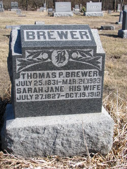
Thomas P. Brewer
| Birth | : | 25 Jul 1831 Kentucky, USA |
| Death | : | 21 Mar 1923 Shelby County, Missouri, USA |
| Burial | : | Pine Hill Cemetery, Kentwood, Kent County, USA |
| Coordinate | : | 42.8675003, -85.6363983 |
| Description | : | Thomas is the son of Thomas Brewer and Mary Evans who were married in 1822 in Nelson County Kentucky. Thomas Brewer died in 1832 and widow Mary is found on the 1840 census in Nelson County. In 1846 Mary deeds her land to her brother, Isaac G Evans, and moved her family to Randolph County Missouri where she marries William Haley in 1846. Contributor: Marsha Liston Bradshaw - [email protected] |
frequently asked questions (FAQ):
-
Where is Thomas P. Brewer's memorial?
Thomas P. Brewer's memorial is located at: Pine Hill Cemetery, Kentwood, Kent County, USA.
-
When did Thomas P. Brewer death?
Thomas P. Brewer death on 21 Mar 1923 in Shelby County, Missouri, USA
-
Where are the coordinates of the Thomas P. Brewer's memorial?
Latitude: 42.8675003
Longitude: -85.6363983
Family Members:
Spouse
Children
Flowers:


Nearby Cemetories:
1. Pine Hill Cemetery
Kentwood, Kent County, USA
Coordinate: 42.8675003, -85.6363983
2. Blain Cemetery
Cutlerville, Kent County, USA
Coordinate: 42.8414001, -85.6335983
3. Rest Lawn Memorial Park
Grand Rapids, Kent County, USA
Coordinate: 42.9007988, -85.6438980
4. Holy Trinity Columbarium
Wyoming, Kent County, USA
Coordinate: 42.8669010, -85.6847490
5. Maple Grove Cemetery
Kentwood, Kent County, USA
Coordinate: 42.9033300, -85.6203400
6. Resurrection Cemetery
Wyoming, Kent County, USA
Coordinate: 42.8905983, -85.6819000
7. Oak Grove Cemetery
Grand Rapids, Kent County, USA
Coordinate: 42.9136009, -85.6314011
8. Woodlawn Cemetery
Grand Rapids, Kent County, USA
Coordinate: 42.9160995, -85.6303024
9. Dutton Cemetery
Dutton, Kent County, USA
Coordinate: 42.8366670, -85.5841670
10. Kent Memorial Gardens
Byron Center, Kent County, USA
Coordinate: 42.8356018, -85.6883011
11. Garfield Park Cemetery
Grand Rapids, Kent County, USA
Coordinate: 42.9221992, -85.6307983
12. Winchester Cemetery
Byron Center, Kent County, USA
Coordinate: 42.8246994, -85.6980972
13. Gaines Cemetery
Cutlerville, Kent County, USA
Coordinate: 42.7976036, -85.6240311
14. Weaver Cemetery
Byron Township, Kent County, USA
Coordinate: 42.8041992, -85.6828003
15. Sleepy Hollow Pet Cemetery and Crematory
Byron Center, Kent County, USA
Coordinate: 42.8477040, -85.7329940
16. Grace Episcopal Church Columbarium
Grand Rapids, Kent County, USA
Coordinate: 42.9413390, -85.6242730
17. Oakhill Cemetery
Grand Rapids, Kent County, USA
Coordinate: 42.9411011, -85.6517029
18. Chapel Hill Memorial Gardens
Cascade Township, Kent County, USA
Coordinate: 42.9089012, -85.5464020
19. Saint Marys Catholic Cemetery
Cascade Township, Kent County, USA
Coordinate: 42.8688890, -85.5283330
20. Saint Andrews Catholic Cemetery
Grand Rapids, Kent County, USA
Coordinate: 42.9463997, -85.6567001
21. Boynton Cemetery
Byron Center, Kent County, USA
Coordinate: 42.8377991, -85.7433014
22. Teeple Cemetery (Defunct)
Cascade Township, Kent County, USA
Coordinate: 42.9134300, -85.5357790
23. Grandville Cemetery
Grandville, Kent County, USA
Coordinate: 42.9043999, -85.7514038
24. Martin Cemetery
Grand Rapids, Kent County, USA
Coordinate: 42.9458008, -85.5607986