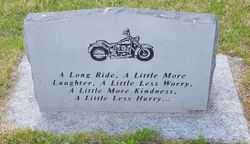
Timothy J Stalcup
| Birth | : | 27 Sep 1961 Creston, Union County, Iowa, USA |
| Death | : | 16 Aug 2015 Kahoka, Clark County, Missouri, USA |
| Burial | : | Groesbeck Cemetery, Lorimor, Union County, USA |
| Coordinate | : | 41.1100006, -94.1230011 |
| Description | : | Timothy J Stalcup, 53, of Kansas City, Missouri, passed away, Aug. 16, 2015. He was born to John and Lucia Stalcup, Sept. 27, 1961, in Creston, Iowa. Tim graduated from Oak Park High School in 1980 Tim worked for the Raytown School District transportation department since 2006. He was well liked by his co-workers and will be missed. Tim enjoyed hunting, traveling the United States on his Harley, racing cars and motorcycles. He is survived by his parents John and Lucia Stalcup. He was also survived by his girlfriend Becky Stewart, three siblings: sisters Theresa (Matt)... Read More |
frequently asked questions (FAQ):
-
Where is Timothy J Stalcup's memorial?
Timothy J Stalcup's memorial is located at: Groesbeck Cemetery, Lorimor, Union County, USA.
-
When did Timothy J Stalcup death?
Timothy J Stalcup death on 16 Aug 2015 in Kahoka, Clark County, Missouri, USA
-
Where are the coordinates of the Timothy J Stalcup's memorial?
Latitude: 41.1100006
Longitude: -94.1230011
Family Members:
Parent
Flowers:
Nearby Cemetories:
1. Groesbeck Cemetery
Lorimor, Union County, USA
Coordinate: 41.1100006, -94.1230011
2. Bragg Cemetery
Lorimor, Union County, USA
Coordinate: 41.1282997, -94.1433029
3. Dodge Center Cemetery
Afton, Union County, USA
Coordinate: 41.1279984, -94.1829987
4. Monette Cemetery
Lorimor, Union County, USA
Coordinate: 41.0800743, -94.0715866
5. Lorimor Cemetery
Lorimor, Union County, USA
Coordinate: 41.1128006, -94.0516968
6. Mount Pisgah Cemetery
Thayer, Union County, USA
Coordinate: 41.0511017, -94.1007996
7. Beulah Cemetery
Thayer, Union County, USA
Coordinate: 41.0589981, -94.0759964
8. Browns Mountain Cemetery
Thayer, Union County, USA
Coordinate: 41.0499992, -94.0999985
9. Bethel Cemetery
Thayer, Union County, USA
Coordinate: 41.0600014, -94.0693970
10. Cedar Grove Cemetery
Lorimor, Union County, USA
Coordinate: 41.1209984, -94.2200012
11. Hickman Cemetery
Grand River Township, Madison County, USA
Coordinate: 41.1652140, -94.2132650
12. Civil War Era Cemetery
Afton, Union County, USA
Coordinate: 41.0460854, -94.2025299
13. Greenlawn Cemetery
Afton, Union County, USA
Coordinate: 41.0335999, -94.1856003
14. Barney Cemetery
Monroe Township, Madison County, USA
Coordinate: 41.1641998, -94.0239029
15. Moon Cemetery
Grand River Township, Madison County, USA
Coordinate: 41.1935997, -94.1810989
16. West Branch Cemetery
Grand River Township, Madison County, USA
Coordinate: 41.1791992, -94.2097015
17. Bullock Cemetery
Monroe Township, Madison County, USA
Coordinate: 41.1960983, -94.0650024
18. Thayer Catholic Cemetery
Thayer, Union County, USA
Coordinate: 41.0374985, -94.0357971
19. West Union Cemetery
Thayer, Union County, USA
Coordinate: 41.0191994, -94.0721970
20. Saint Edwards Catholic Cemetery
Afton, Union County, USA
Coordinate: 41.0359993, -94.2129974
21. Norris Plot Cemetery
Afton, Union County, USA
Coordinate: 41.0079994, -94.1579971
22. Hamblin Cemetery
Monroe Township, Madison County, USA
Coordinate: 41.2214012, -94.0958023
23. Otterbein Cemetery
Thayer, Union County, USA
Coordinate: 40.9990005, -94.0879974
24. Claypool Cemetery
Thayer, Union County, USA
Coordinate: 41.0126114, -94.0303497


