

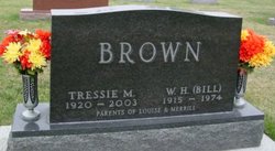
Tressie Mae West Brown
| Birth | : | 5 May 1920 Iowa, USA |
| Death | : | 13 Aug 2003 USA |
| Burial | : | Johnson Cemetery, Presque Isle, Aroostook County, USA |
| Coordinate | : | 46.7078209, -68.0069733 |
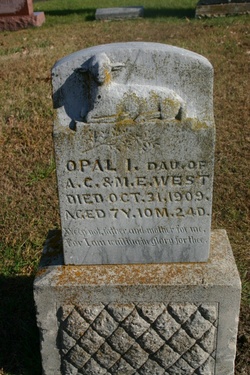
| Description | : | Tressie Mae West was born to Margaret Ellen and Asa West, who are buried at this cemertary also. She was a younger sister to Opal West, who is buried at the Wheelis (otherwise known as Tennesse) Cemetary. She later married to William H. Brown, who is buried right beside her. They had two children, Merrill and Marie Louise. Tressie had several grandchildren and great grandchildren. She loved to spend time with her family and garden. |
frequently asked questions (FAQ):
-
Where is Tressie Mae West Brown's memorial?
Tressie Mae West Brown's memorial is located at: Johnson Cemetery, Presque Isle, Aroostook County, USA.
-
When did Tressie Mae West Brown death?
Tressie Mae West Brown death on 13 Aug 2003 in USA
-
Where are the coordinates of the Tressie Mae West Brown's memorial?
Latitude: 46.7078209
Longitude: -68.0069733
Family Members:
Parent

Spouse
Siblings

Children
Flowers:


Nearby Cemetories:
1. Johnson Cemetery
Presque Isle, Aroostook County, USA
Coordinate: 46.7078209, -68.0069733
2. Saint Marys Cemetery
Presque Isle, Aroostook County, USA
Coordinate: 46.6930930, -68.0104730
3. Saint Marys Chapman Street Cemetery
Presque Isle, Aroostook County, USA
Coordinate: 46.6754150, -68.0215990
4. Bartlett Cemetery
Presque Isle, Aroostook County, USA
Coordinate: 46.6765327, -67.9827118
5. Reuben Bean Family Cemetery
Aroostook County, USA
Coordinate: 46.7141610, -67.9514610
6. Fairmount Cemetery
Presque Isle, Aroostook County, USA
Coordinate: 46.6628075, -68.0077744
7. Bean Family Cemetery
Aroostook County, USA
Coordinate: 46.7396440, -67.9542600
8. Hillside Grove Cemetery
Crouseville, Aroostook County, USA
Coordinate: 46.7566760, -68.0765500
9. Crouseville Cemetery
Crouseville, Aroostook County, USA
Coordinate: 46.7574997, -68.0768967
10. Estes Park Cemetery
Easton, Aroostook County, USA
Coordinate: 46.6418110, -67.9181820
11. Knight Cemetery
Fort Fairfield, Aroostook County, USA
Coordinate: 46.6876150, -67.8778140
12. Lyndon Center Cemetery
Caribou, Aroostook County, USA
Coordinate: 46.8022240, -67.9921920
13. Haines Maple Grove Cemetery
Fort Fairfield, Aroostook County, USA
Coordinate: 46.7233160, -67.8699040
14. Pine Tree Cemetery
Easton, Aroostook County, USA
Coordinate: 46.6774640, -67.8727940
15. Greenridge Cemetery
Caribou, Aroostook County, USA
Coordinate: 46.7923622, -67.9321976
16. Thompson Burial Ground
Caribou, Aroostook County, USA
Coordinate: 46.8143280, -67.9821140
17. Union Cemetery
Fort Fairfield, Aroostook County, USA
Coordinate: 46.7566150, -67.8655240
18. Harvey Hill Cemetery
McShea, Aroostook County, USA
Coordinate: 46.7567099, -67.8652997
19. Old Mill Town Cemetery
Mapleton, Aroostook County, USA
Coordinate: 46.6815700, -68.1609100
20. Grendell Cemetery
Chapman, Aroostook County, USA
Coordinate: 46.6364010, -68.1318340
21. Southside Cemetery
Mapleton, Aroostook County, USA
Coordinate: 46.6622050, -68.1633620
22. Mount Shiloh Cemetery
Easton, Aroostook County, USA
Coordinate: 46.6362460, -67.8670810
23. Washburn Riverside Extension Cemetery
Washburn, Aroostook County, USA
Coordinate: 46.7750816, -68.1517105
24. Castle Hill Cemetery
Castle Hill, Aroostook County, USA
Coordinate: 46.7346840, -68.1792210