
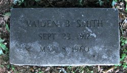
Vaiden Barto Smith
| Birth | : | 23 Sep 1912 Mecklenburg County, North Carolina, USA |
| Death | : | 8 May 1960 Chattanooga, Hamilton County, Tennessee, USA |
| Burial | : | Netherton Lane Cemetery, Bedlington, Northumberland Unitary Authority, England |
| Coordinate | : | 55.1318960, -1.6106800 |
| Description | : | Funeral services for Vaide Barto Smith, 48, of 1504 Lyon Ct., who died in a Chattanooga, Tenn., hospital yesterday, will be held at 11 a.m. tomorrow in McEwen West Chapel. The Rev. G. E. Dixon, pastor of W. H. Belk Presbyterian Church, will officiate. Interment will be in Flint Hill Baptist Church cemetery. Mr. Smith was born Sept. 23, 1912, in Mecklenburg County, son of the late Carlton and Ava Windle Smith. Survivors include three sons, Vernon Smith of the U. S. Air Force, Benny and Charlton Smith of the home; three brothers, W. M., J.... Read More |
frequently asked questions (FAQ):
-
Where is Vaiden Barto Smith's memorial?
Vaiden Barto Smith's memorial is located at: Netherton Lane Cemetery, Bedlington, Northumberland Unitary Authority, England.
-
When did Vaiden Barto Smith death?
Vaiden Barto Smith death on 8 May 1960 in Chattanooga, Hamilton County, Tennessee, USA
-
Where are the coordinates of the Vaiden Barto Smith's memorial?
Latitude: 55.1318960
Longitude: -1.6106800
Family Members:
Parent

Siblings

Flowers:


Nearby Cemetories:
1. Netherton Lane Cemetery
Bedlington, Northumberland Unitary Authority, England
Coordinate: 55.1318960, -1.6106800
2. St. Cuthbert Churchyard
Bedlington, Northumberland Unitary Authority, England
Coordinate: 55.1303910, -1.5928880
3. St. Paul's Churchyard
Choppington, Northumberland Unitary Authority, England
Coordinate: 55.1494290, -1.6009780
4. St. Mary's Churchyard
Horton, Northumberland Unitary Authority, England
Coordinate: 55.1106200, -1.5706200
5. Cowpen Roman Catholic Burial Ground
Blyth, Northumberland Unitary Authority, England
Coordinate: 55.1305300, -1.5386300
6. St Peter Churchyard
Cambois, Northumberland Unitary Authority, England
Coordinate: 55.1615300, -1.5604100
7. St Andrew's Churchyard
Bothal, Northumberland Unitary Authority, England
Coordinate: 55.1731340, -1.6205890
8. North Seaton Cemetery
Ashington, Northumberland Unitary Authority, England
Coordinate: 55.1669770, -1.5575500
9. Cowpen Cemetery and Crematorium
Blyth, Northumberland Unitary Authority, England
Coordinate: 55.1311260, -1.5294460
10. St. Nicholas' Churchyard
Cramlington, Northumberland Unitary Authority, England
Coordinate: 55.0856460, -1.5834930
11. Mayfield Cemetery
Cramlington, Northumberland Unitary Authority, England
Coordinate: 55.0837139, -1.5730931
12. Saint Aidens Churchyard
Ashington, Northumberland Unitary Authority, England
Coordinate: 55.1826900, -1.5781400
13. St. Mary the Virgin Church
Morpeth, Northumberland Unitary Authority, England
Coordinate: 55.1598990, -1.6917760
14. St. Mary the Virgin Churchyard
Morpeth, Northumberland Unitary Authority, England
Coordinate: 55.1597110, -1.6921530
15. Saint Cuthbert's Churchyard
Blyth, Northumberland Unitary Authority, England
Coordinate: 55.1265800, -1.5031400
16. Newminster Abbey
Morpeth, Northumberland Unitary Authority, England
Coordinate: 55.1664000, -1.7044070
17. Saint John's Churchyard
Longhirst, Northumberland Unitary Authority, England
Coordinate: 55.1936200, -1.6474840
18. St. John's Churchyard
Annitsford, Metropolitan Borough of North Tyneside, England
Coordinate: 55.0676900, -1.5785500
19. St. John the Baptist Catholic Churchyard
Cramlington, Northumberland Unitary Authority, England
Coordinate: 55.0675480, -1.5783300
20. Blyth Links Cemetery
Blyth, Northumberland Unitary Authority, England
Coordinate: 55.1053800, -1.4997200
21. Dudley Cemetery
Dudley, Metropolitan Borough of North Tyneside, England
Coordinate: 55.0566100, -1.6143420
22. Saint Mary Magdalene Churchyard
Mitford, Northumberland Unitary Authority, England
Coordinate: 55.1645410, -1.7363020
23. Fairmoor Cemetery
Morpeth, Northumberland Unitary Authority, England
Coordinate: 55.1861980, -1.7163260
24. Lynemouth Cemetery
Lynemouth, Northumberland Unitary Authority, England
Coordinate: 55.2031759, -1.5361996