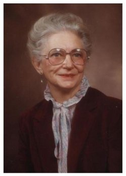
Velma Marie Mueller Mangold
| Birth | : | 30 Aug 1915 |
| Death | : | 29 Dec 2006 |
| Burial | : | Pine Grove Cemetery, Berea, Ritchie County, USA |
| Coordinate | : | 39.1314011, -80.9321976 |
| Inscription | : | Married 1935 Parents of William, Susan and Jean |
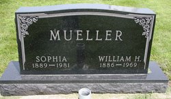
| Description | : | Velma Mangold, 91, died on Dec. 29, 2006 at Harding Nursing Home in Waterville N.Y. Funeral services will be held at the St. John's United Church of Christ, South of Peterson, on Friday, Jan. 5, 2007, at 2 p.m. with the Rev. Mike Tolles officiating. Burial in the cemetery at St. John's United Church of Christ, the same church founded by her German ancestors and where she was baptized, confirmed, and married. Mangold, long-time Alta resident, was born on August 30, 1915, to Wm. H. and Sophie Luetkeman Mueller on a farm in Brooke Township, Buena Vista County. She was baptized... Read More |
frequently asked questions (FAQ):
-
Where is Velma Marie Mueller Mangold's memorial?
Velma Marie Mueller Mangold's memorial is located at: Pine Grove Cemetery, Berea, Ritchie County, USA.
-
When did Velma Marie Mueller Mangold death?
Velma Marie Mueller Mangold death on 29 Dec 2006 in
-
Where are the coordinates of the Velma Marie Mueller Mangold's memorial?
Latitude: 39.1314011
Longitude: -80.9321976
Family Members:
Parent
Spouse
Siblings
Flowers:
Nearby Cemetories:
1. Pleasant Hill Cemetery
Berea, Ritchie County, USA
Coordinate: 39.1162100, -80.9682300
2. Pine Low Gap Cemetery
Burnt House, Ritchie County, USA
Coordinate: 39.1006400, -80.9562200
3. Toothman Cemetery
Pullman, Ritchie County, USA
Coordinate: 39.1666680, -80.9175640
4. Spruce Creek Cemetery
Auburn, Ritchie County, USA
Coordinate: 39.0807300, -80.9083700
5. Mount Zion United Brethren Church Cemetery
Five Forks, Ritchie County, USA
Coordinate: 39.1544000, -80.9971300
6. Smith Chapel Cemetery
Prunty, Ritchie County, USA
Coordinate: 39.1121700, -80.9995900
7. Pullman Church Cemetery
Pullman, Ritchie County, USA
Coordinate: 39.1871986, -80.9480972
8. Britton Cemetery
Hazelgreen, Ritchie County, USA
Coordinate: 39.0841500, -80.9894000
9. Mount Pisgah Cemetery
Ritchie County, USA
Coordinate: 39.1949501, -80.9705200
10. Auburn Community Cemetery
Auburn, Ritchie County, USA
Coordinate: 39.0960999, -80.8533020
11. Hazelgreen Cemetery
Ritchie County, USA
Coordinate: 39.0853004, -81.0021973
12. Chevauxdefrise Cemetery
Ritchie County, USA
Coordinate: 39.1584100, -81.0192600
13. Bethany Cemetery
Harrisville, Ritchie County, USA
Coordinate: 39.0956700, -81.0219500
14. Carroll Cemetery
Summers, Doddridge County, USA
Coordinate: 39.1681010, -80.8430240
15. Mount Olive Cemetery
Burnt House, Ritchie County, USA
Coordinate: 39.0531006, -80.9257965
16. South Fork Cemetery
Oxford, Doddridge County, USA
Coordinate: 39.1672180, -80.8404270
17. South Fork Eastern Cemetery
Doddridge County, USA
Coordinate: 39.1657982, -80.8383026
18. Reeves Cemetery
Goffs, Ritchie County, USA
Coordinate: 39.0882988, -81.0246964
19. Lloyd Brydie Family Cemetery
Harrisville, Ritchie County, USA
Coordinate: 39.1315200, -81.0416200
20. New Mount Olive Cemetery
Burnt House, Ritchie County, USA
Coordinate: 39.0446100, -80.9340200
21. Auburn Baptist Church Cemetery
Auburn, Ritchie County, USA
Coordinate: 39.0819200, -80.8384600
22. Hall Cemetery
Gilmer County, USA
Coordinate: 39.0816994, -80.8383026
23. Oxford Cemetery
Doddridge County, USA
Coordinate: 39.2006920, -80.8610770
24. Horn Creek Baptist Church Cemetery
Gilmer County, USA
Coordinate: 39.0605700, -80.8633500


