

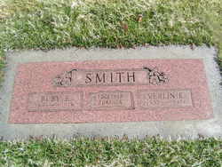
Verlin Edgar Smith
| Birth | : | 2 Aug 1897 Wild Cherry, Fulton County, Arkansas, USA |
| Death | : | 6 Aug 1976 Chelan, Chelan County, Washington, USA |
| Burial | : | Mount Moriah Church Cemetery, Ballsville, Powhatan County, USA |
| Coordinate | : | 37.5007553, -78.0635147 |
| Plot | : | Row 20, Block 44, Lot 2 |
| Inscription | : | Ruby E. Smith - together forever |
| Description | : | Edger Verlin Smith, 79, a long-time resident of this area, died Friday morning at Lake Chelan Community Hospital following an extended illness. Mr. Smith was born Aug. 2, 1897, at Wild Cherry, Arkansas, and moved with his family to Mansfield in 1903. In 1927, he was married to Ruby Weir at Fresno, Ca. Following their marriage, they made their home in Idaho for a short time before moving to Chelan. For 12 years, Mr. Smith was employed with the Town of Chelan and during part of that time, he served as Chief of Police. From 1945 until 1961, he was... Read More |
frequently asked questions (FAQ):
-
Where is Verlin Edgar Smith's memorial?
Verlin Edgar Smith's memorial is located at: Mount Moriah Church Cemetery, Ballsville, Powhatan County, USA.
-
When did Verlin Edgar Smith death?
Verlin Edgar Smith death on 6 Aug 1976 in Chelan, Chelan County, Washington, USA
-
Where are the coordinates of the Verlin Edgar Smith's memorial?
Latitude: 37.5007553
Longitude: -78.0635147
Family Members:
Parent

Spouse
Siblings
Flowers:


Nearby Cemetories:
1. Mount Moriah Church Cemetery
Ballsville, Powhatan County, USA
Coordinate: 37.5007553, -78.0635147
2. Mount Pero Baptist Church Cemetery
Ballsville, Powhatan County, USA
Coordinate: 37.5010050, -78.0617530
3. Martin Family Cemetery
Powhatan County, USA
Coordinate: 37.5068600, -78.0374000
4. Heath Family Cemetery
Powhatan County, USA
Coordinate: 37.5074400, -78.0288900
5. Full Gospel Church Cemetery
Powhatan, Powhatan County, USA
Coordinate: 37.5108740, -78.0300770
6. Hobson’s Chapel United Methodist Church Cemetery
Powhatan, Powhatan County, USA
Coordinate: 37.4800180, -78.1063600
7. Providence Presbyterian Church Cemetery
Powhatan, Powhatan County, USA
Coordinate: 37.5249760, -78.0081250
8. Brown Family Cemetery
Ballsville, Powhatan County, USA
Coordinate: 37.5473830, -78.0899740
9. Haden-Ware Family Cemetery
Goochland County, USA
Coordinate: 37.4474300, -78.0417300
10. Hickman-Hickmon & Criss Family Cemetery
Macon, Powhatan County, USA
Coordinate: 37.5122660, -77.9850680
11. Epworth Methodist Church Cemetery
Amelia Court House, Amelia County, USA
Coordinate: 37.4538910, -78.0054150
12. Bowles Family Cemetery
Cumberland, Cumberland County, USA
Coordinate: 37.5406408, -78.1297578
13. Rising Zion Baptist Church Cemetery
Cumberland County, USA
Coordinate: 37.5411790, -78.1351110
14. Center Union Baptist Church Cemetery
Cumberland, Cumberland County, USA
Coordinate: 37.4766273, -78.1461411
15. Flower Hill Baptist Church Cemetery
Amelia Court House, Amelia County, USA
Coordinate: 37.4410030, -78.0164660
16. Piedmont Church Cemetery
Amelia County, USA
Coordinate: 37.4428810, -78.0104420
17. Mount Zion Baptist Church Cemetery
Powhatan, Powhatan County, USA
Coordinate: 37.5630360, -78.0125680
18. Pilgrim Mennonite Church Cemetery
Amelia County, USA
Coordinate: 37.4467960, -77.9922100
19. Little Union Baptist Church Cemetery
Amelia Court House, Amelia County, USA
Coordinate: 37.4211450, -78.0785190
20. Hague Family Cemetery
Powhatan County, USA
Coordinate: 37.5237700, -77.9635900
21. Bates Family Cemetery
Powhatan County, USA
Coordinate: 37.5237500, -77.9634900
22. Pine Hill Baptist Church Cemetery
Macon, Powhatan County, USA
Coordinate: 37.5089100, -77.9566060
23. Salmon Family Cemetery
Powhatan, Powhatan County, USA
Coordinate: 37.5471640, -77.9711170
24. Grove Cemetery
Cumberland, Cumberland County, USA
Coordinate: 37.4860992, -78.1750031