
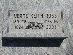
Verne Keith Ross
| Birth | : | 28 ??? 1924 Kansas, USA |
| Death | : | 16 May 2003 Kincaid, Anderson County, Kansas, USA |
| Burial | : | Fairview Cemetery, Mildred, Allen County, USA |
| Coordinate | : | 38.0238020, -95.1401740 |
| Description | : | Chanute Tribune, The (KS) - Saturday, May 17, 2003 Verne Keith Ross, 79, rural Kincaid, died Friday, May 16, 2003, at his residence. He was born on Jan. 28, 1924, in rural Bronson, the son of Jesse and Bessie Whittington Ross. He was raised in the Bronson and Mildred areas. He attended Glendale Grade School and graduated from Mildred High School in 1941. He served in the U.S. Army during World War II in the European Theater. After the war he returned home to the family farm. He was a life-long farmer. He was a member of the Kincaid V.F.W.... Read More |
frequently asked questions (FAQ):
-
Where is Verne Keith Ross's memorial?
Verne Keith Ross's memorial is located at: Fairview Cemetery, Mildred, Allen County, USA.
-
When did Verne Keith Ross death?
Verne Keith Ross death on 16 May 2003 in Kincaid, Anderson County, Kansas, USA
-
Where are the coordinates of the Verne Keith Ross's memorial?
Latitude: 38.0238020
Longitude: -95.1401740
Family Members:
Spouse

Children
Flowers:


Nearby Cemetories:
1. Fairview Cemetery
Mildred, Allen County, USA
Coordinate: 38.0238020, -95.1401740
2. Osage Valley Cemetery
Mildred, Allen County, USA
Coordinate: 38.0313988, -95.0969009
3. Stanley Cemetery
Bayard, Allen County, USA
Coordinate: 37.9944200, -95.0970400
4. Gillham Cemetery
Allen County, USA
Coordinate: 37.9795100, -95.1103500
5. Kincaid Cemetery
Kincaid, Anderson County, USA
Coordinate: 38.0917015, -95.1513977
6. Mount Zion Cemetery
Kincaid, Anderson County, USA
Coordinate: 38.1046982, -95.1864014
7. Boulware Cemetery
Mapleton, Bourbon County, USA
Coordinate: 38.0264600, -95.0245400
8. Old Blue Mound Cemetery
Blue Mound, Linn County, USA
Coordinate: 38.0636600, -95.0249000
9. Entswood Cemetery
Bronson, Bourbon County, USA
Coordinate: 37.9431480, -95.0603200
10. Lone Elm Cemetery
Lone Elm, Anderson County, USA
Coordinate: 38.0882988, -95.2422028
11. Anderson Cemetery #1
Xenia, Bourbon County, USA
Coordinate: 37.9907700, -95.0025000
12. Pleasant View Cemetery
Blue Mound, Linn County, USA
Coordinate: 38.0952988, -95.0175018
13. Sunny Slope Cemetery
Blue Mound, Linn County, USA
Coordinate: 38.0952988, -95.0149994
14. Stevenson Cemetery
Mapleton, Bourbon County, USA
Coordinate: 38.0210991, -94.9847031
15. Moran Cemetery
Moran, Allen County, USA
Coordinate: 37.9068985, -95.1892014
16. Ozark Cemetery #1
Anderson County, USA
Coordinate: 38.0424200, -95.2992300
17. Bronson Cemetery
Bronson, Bourbon County, USA
Coordinate: 37.8997100, -95.0792500
18. Pleasant Valley Cemetery
Allen County, USA
Coordinate: 38.0093994, -95.3328018
19. Oakwood Cemetery
Centerville, Linn County, USA
Coordinate: 38.1605988, -95.0391998
20. Golden Valley Cemetery
Allen County, USA
Coordinate: 37.8792572, -95.2235718
21. Pleasant View Cemetery
Bronson, Bourbon County, USA
Coordinate: 37.8996900, -95.0040500
22. Northway Cemetery
Mapleton, Bourbon County, USA
Coordinate: 37.9935989, -94.9321976
23. Sugar Valley Cemetery
Anderson County, USA
Coordinate: 38.1903300, -95.1130200
24. La Harpe Cemetery
La Harpe, Allen County, USA
Coordinate: 37.9067001, -95.3022003