

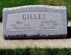
Vernon John “Bill” Gilles
| Birth | : | 18 May 1912 Osage, Mitchell County, Iowa, USA |
| Death | : | 4 Sep 1991 Osage, Mitchell County, Iowa, USA |
| Burial | : | Sacred Heart Cemetery, Osage, Mitchell County, USA |
| Coordinate | : | 43.2742004, -92.7917023 |
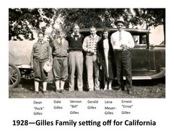
| Description | : | Osage - Vernon "Bill" Gilles, 79, of Osage, died at his home Wednesday, Sept. 4, 1991, of natural causes. Survivors include his wife, Dorothy; a daughter, Susan Safire of Virginia Beach, Va.; three sons, Michael of Huntington Beach, Calif., Patrick of Topeka, Kan., and Jeffrey of Redmond, Wash.; eight grandchildren; three brothers, Gerald of Los Angeles, Dean of Braden-ton, Fla., and Dale of Japan. Services will be 10 a.m. Saturday at Sacred Heart Catholic Church, Osage, with burial in the church cemetery; friends may call after 2 p.m. today at Champion Funeral Home, Osage, where there will be... Read More |
frequently asked questions (FAQ):
-
Where is Vernon John “Bill” Gilles's memorial?
Vernon John “Bill” Gilles's memorial is located at: Sacred Heart Cemetery, Osage, Mitchell County, USA.
-
When did Vernon John “Bill” Gilles death?
Vernon John “Bill” Gilles death on 4 Sep 1991 in Osage, Mitchell County, Iowa, USA
-
Where are the coordinates of the Vernon John “Bill” Gilles's memorial?
Latitude: 43.2742004
Longitude: -92.7917023
Family Members:
Parent
Spouse

Siblings
Children
Flowers:


Nearby Cemetories:
1. Sacred Heart Cemetery
Osage, Mitchell County, USA
Coordinate: 43.2742004, -92.7917023
2. South Osage Mennonite Church Cemetery
Osage, Mitchell County, USA
Coordinate: 43.2544556, -92.7915573
3. Osage Cemetery
Osage, Mitchell County, USA
Coordinate: 43.2916700, -92.8201700
4. Tucker Cemetery
Osage, Mitchell County, USA
Coordinate: 43.2494011, -92.8319016
5. Orchard Cemetery
Orchard, Mitchell County, USA
Coordinate: 43.2249985, -92.7838898
6. Calvary Cemetery
Osage, Mitchell County, USA
Coordinate: 43.2238998, -92.8300018
7. Oak Grove Cemetery
Mitchell, Mitchell County, USA
Coordinate: 43.3156013, -92.8707962
8. Dudley Cemetery
Dudley (historical), Mitchell County, USA
Coordinate: 43.2252998, -92.8743973
9. Rock Creek Cemetery
Meroa, Mitchell County, USA
Coordinate: 43.2352791, -92.9225006
10. Stillwater Cemetery
Orchard, Mitchell County, USA
Coordinate: 43.2130585, -92.6780624
11. Eden Presbyterian Cemetery
Meroa, Mitchell County, USA
Coordinate: 43.2131004, -92.9103012
12. Beaver Creek Cemetery
Brownville, Mitchell County, USA
Coordinate: 43.3397217, -92.6727829
13. Saint Peters Cemetery
New Haven, Mitchell County, USA
Coordinate: 43.2858315, -92.6427765
14. Howardville Cemetery
Floyd, Floyd County, USA
Coordinate: 43.1866989, -92.7016983
15. West End Cemetery
Meroa, Mitchell County, USA
Coordinate: 43.2216682, -92.9250031
16. Riverview Cemetery
Saint Ansgar, Mitchell County, USA
Coordinate: 43.3430328, -92.9220200
17. Liberty Cemetery
Little Cedar, Mitchell County, USA
Coordinate: 43.3856010, -92.7230988
18. Saint Ansgar Cemetery
Saint Ansgar, Mitchell County, USA
Coordinate: 43.3777809, -92.9094391
19. Immanuel Lutheran Cemetery
Saint Ansgar, Mitchell County, USA
Coordinate: 43.3717003, -92.9257965
20. First Lutheran Cemetery
Saint Ansgar, Mitchell County, USA
Coordinate: 43.3841705, -92.9194412
21. Blakestad Cemetery
Saint Ansgar, Mitchell County, USA
Coordinate: 43.3711014, -92.9400024
22. Saint Johns Lutheran Cemetery
Rock Creek, Mitchell County, USA
Coordinate: 43.3295560, -92.9849770
23. Saint Johns Lutheran Old Cemetery
Rock Creek, Mitchell County, USA
Coordinate: 43.3313904, -92.9897232
24. Stacyville Cemetery
Stacyville, Mitchell County, USA
Coordinate: 43.4294014, -92.7908020