
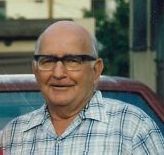
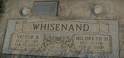
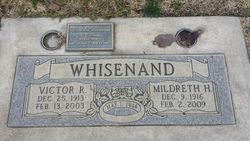
Victor Ray Whisenand
| Birth | : | 25 Dec 1913 Omaha, Douglas County, Nebraska, USA |
| Death | : | 13 Feb 2003 Sacramento County, California, USA |
| Burial | : | Galt Cemetery, Galt, Sacramento County, USA |
| Coordinate | : | 38.2414017, -121.3013992 |
| Description | : | Victor Whisenand, of Galt passed away from natural causes on Feb. 13, 2003. He was 89. He was born in Omaha, Nebraska on Dec. 25, 1913. He lived in Baldwin Park and Whittier from 1956-1994. He was a resident of Galt since 1994. He was retired from Cal Tech's Jet Propulsion Laboratory in 1976 after 20 years of service. He served in WWII in the 26th Signal Corp. of the United States Army in Europe. He was awarded Battle Stars for Normandy, Northern France, Ardennes, Rhineland and Central Europe campaigns. He was a proud member of the Lions Club of Galt and Southern California... Read More |
frequently asked questions (FAQ):
-
Where is Victor Ray Whisenand's memorial?
Victor Ray Whisenand's memorial is located at: Galt Cemetery, Galt, Sacramento County, USA.
-
When did Victor Ray Whisenand death?
Victor Ray Whisenand death on 13 Feb 2003 in Sacramento County, California, USA
-
Where are the coordinates of the Victor Ray Whisenand's memorial?
Latitude: 38.2414017
Longitude: -121.3013992
Family Members:
Parent
Spouse
Siblings


Nearby Cemetories:
1. Galt Cemetery
Galt, Sacramento County, USA
Coordinate: 38.2414017, -121.3013992
2. Liberty Cemetery
Acampo, San Joaquin County, USA
Coordinate: 38.2350006, -121.2782974
3. De Vries Ranch Family Cemetery
Lodi, San Joaquin County, USA
Coordinate: 38.2005530, -121.3556060
4. Hicksville Cemetery
Hicksville, Sacramento County, USA
Coordinate: 38.3257942, -121.3190765
5. Woodbridge Masonic Cemetery
Woodbridge, San Joaquin County, USA
Coordinate: 38.1496506, -121.3016663
6. Elliott Cemetery
San Joaquin County, USA
Coordinate: 38.2341995, -121.1761017
7. Fairbanks Ranch Cemetery
San Joaquin County, USA
Coordinate: 38.2310250, -121.1725170
8. Lodi Memorial Park and Cemetery
Lodi, San Joaquin County, USA
Coordinate: 38.1319008, -121.2455978
9. Saint John The Baptist Episcopal Columbarium
Lodi, San Joaquin County, USA
Coordinate: 38.1213500, -121.3074400
10. Locke Cemetery
Lockeford, San Joaquin County, USA
Coordinate: 38.1758003, -121.1616974
11. Harmony Grove Cemetery
Lockeford, San Joaquin County, USA
Coordinate: 38.1478004, -121.1755981
12. Saint Joachim Catholic Cemetery
Lockeford, San Joaquin County, USA
Coordinate: 38.1478400, -121.1752500
13. Islamic Cemetery of California
Lodi, San Joaquin County, USA
Coordinate: 38.1091730, -121.2563590
14. Cherokee Memorial Park
Lodi, San Joaquin County, USA
Coordinate: 38.1017303, -121.2585983
15. Live Oak Cemetery
Lodi, San Joaquin County, USA
Coordinate: 38.0868760, -121.2874780
16. Point Pleasant Cemetery
Point Pleasant, Sacramento County, USA
Coordinate: 38.3308525, -121.4638290
17. Old Mackville Cemetery
Clements, San Joaquin County, USA
Coordinate: 38.2143200, -121.0968300
18. Sharp Family Cemetery
Walnut Grove, Sacramento County, USA
Coordinate: 38.2351900, -121.5135800
19. Glen View Cemetery
Clements, San Joaquin County, USA
Coordinate: 38.2022018, -121.0883026
20. Hilltop Cemetery
Elk Grove, Sacramento County, USA
Coordinate: 38.4156490, -121.3534950
21. Elk Grove Cosumnes-Cemetery
Elk Grove, Sacramento County, USA
Coordinate: 38.4088593, -121.3875504
22. Franklin Cemetery
Franklin, Sacramento County, USA
Coordinate: 38.3761749, -121.4558029
23. Pleasant Grove Cemetery
Elk Grove, Sacramento County, USA
Coordinate: 38.4302220, -121.3107670
24. East Lawn Elk Grove Memorial Park
Elk Grove, Sacramento County, USA
Coordinate: 38.4282608, -121.3969955