
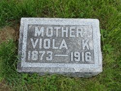
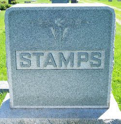
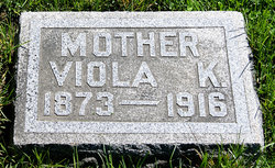
Viola K Knopp Stamps
| Birth | : | Aug 1873 Wayne County, Illinois, USA |
| Death | : | 23 Nov 1916 Taylor County, Iowa, USA |
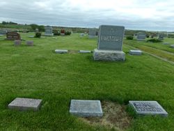
| Burial | : | Wellow & Shoscombe Cemetery, Wellow, Bath and North East Somerset Unitary Authority, England |
| Coordinate | : | 51.3165527, -2.3916632 |
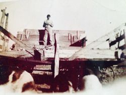
| Description | : | Bedford Free Press (Bedford, Iowa), Tuesday, December 5, 1916, p. 5 New Market Mrs. J. [ames] L. [ee] Stamps died at her home near Guss November 23, aged 43 years. She leaves to mourn her loss her husband and two sons, Glen and Ray. Also her father, David Knopp and two brothers and three sisters. The funeral services were held at the Methodist Episcopal church in Guss and interment was made in the Guss cemetery. Bedford Times-Republican (Bedford, Iowa), Thursday, December 7, 1916, p. Mrs. J. [ames] L. [ee] Stamps of Guss vicinity passed away on November 23rd. the deceased was a member... Read More |
frequently asked questions (FAQ):
-
Where is Viola K Knopp Stamps's memorial?
Viola K Knopp Stamps's memorial is located at: Wellow & Shoscombe Cemetery, Wellow, Bath and North East Somerset Unitary Authority, England.
-
When did Viola K Knopp Stamps death?
Viola K Knopp Stamps death on 23 Nov 1916 in Taylor County, Iowa, USA
-
Where are the coordinates of the Viola K Knopp Stamps's memorial?
Latitude: 51.3165527
Longitude: -2.3916632
Family Members:
Parent


Spouse
Siblings
Children
Flowers:


Nearby Cemetories:
1. Wellow & Shoscombe Cemetery
Wellow, Bath and North East Somerset Unitary Authority, England
Coordinate: 51.3165527, -2.3916632
2. St Julian's Churchyard
Wellow, Bath and North East Somerset Unitary Authority, England
Coordinate: 51.3240160, -2.3717630
3. Ashgrove Cemetery
Peasedown St John, Bath and North East Somerset Unitary Authority, England
Coordinate: 51.3181600, -2.4150760
4. Foxcote St James' The Less Churchyard
Shoscombe, Bath and North East Somerset Unitary Authority, England
Coordinate: 51.2985762, -2.4092987
5. St. James the Less Churchyard
Foxcote, Mendip District, England
Coordinate: 51.2985540, -2.4093370
6. Combe Hay Parish Churchyard
Combe Hay, Bath and North East Somerset Unitary Authority, England
Coordinate: 51.3371120, -2.3817390
7. All Saints Church
Dunkerton, Bath and North East Somerset Unitary Authority, England
Coordinate: 51.3320390, -2.4158600
8. Combe Hay Cemetery
Combe Hay, Bath and North East Somerset Unitary Authority, England
Coordinate: 51.3397819, -2.3814323
9. St. John the Baptist Churchyard
Peasedown St John, Bath and North East Somerset Unitary Authority, England
Coordinate: 51.3164630, -2.4327370
10. Withyditch Baptist Chapel
Bath, Bath and North East Somerset Unitary Authority, England
Coordinate: 51.3328833, -2.4273859
11. St. Mary Magdalene Churchyard
Writhlington, Bath and North East Somerset Unitary Authority, England
Coordinate: 51.2938240, -2.4262230
12. St. Peter's Churchyard
Camerton, Bath and North East Somerset Unitary Authority, England
Coordinate: 51.3150300, -2.4503700
13. St. James' Churchyard
South Stoke, Bath and North East Somerset Unitary Authority, England
Coordinate: 51.3497220, -2.3652780
14. Midford Burial Ground
Bath, Bath and North East Somerset Unitary Authority, England
Coordinate: 51.3394360, -2.3391424
15. Saint Luke & Saint Andrew
Priston, Bath and North East Somerset Unitary Authority, England
Coordinate: 51.3419170, -2.4421910
16. Blessed St Mary the Virgin Churchyard
Hemington, Mendip District, England
Coordinate: 51.2758698, -2.3925455
17. Bath Union Workhouse Burial Ground
Bath, Bath and North East Somerset Unitary Authority, England
Coordinate: 51.3570889, -2.3773370
18. Norton St. Philip Churchyard
Norton St Philip, Mendip District, England
Coordinate: 51.3001680, -2.3279700
19. Bath Union Workhouse Graveyard
Bath, Bath and North East Somerset Unitary Authority, England
Coordinate: 51.3584160, -2.3711140
20. St. John the Baptist Churchyard
Hinton Charterhouse, Bath and North East Somerset Unitary Authority, England
Coordinate: 51.3233330, -2.3219440
21. St. Nicholas' Churchyard
Radstock, Bath and North East Somerset Unitary Authority, England
Coordinate: 51.2900740, -2.4488510
22. Holy Trinity Churchyard
Clandown, Bath and North East Somerset Unitary Authority, England
Coordinate: 51.3024050, -2.4611700
23. St Peter Churchyard
Englishcombe, Bath and North East Somerset Unitary Authority, England
Coordinate: 51.3640600, -2.4088700
24. Jewish Burial Ground
Combe Down, Bath and North East Somerset Unitary Authority, England
Coordinate: 51.3599170, -2.3534670