
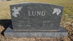
Viola Roberts Lund /Thorman
| Birth | : | 14 Nov 1920 Riley County, Kansas, USA |
| Death | : | 7 Jun 2009 Manhattan, Riley County, Kansas, USA |
| Burial | : | Fancy Creek Cemetery, Green, Clay County, USA |
| Coordinate | : | 39.4668999, -96.9969025 |
| Description | : | Mrs. Thorman was born, November 14, 1920, at Riley County,KS, the daughter of Manford and Vivian (Dugan) Roberts. She was raised in the May Day Community. She attended Longview school and graduated from Green High School in 1939. After graduation, she taught at Longview for three years. Viola married Ervin Lund on May 29, 1940. They lived in Lasita and May Day communities before settling in the Fact Community where they operated a dairy farm. They moved to Clay Center in 1990. Ervin preceded her in death on January 15, 1994. Viola married Eldon Thorman on July 27, 2002. They... Read More |
frequently asked questions (FAQ):
-
Where is Viola Roberts Lund /Thorman's memorial?
Viola Roberts Lund /Thorman's memorial is located at: Fancy Creek Cemetery, Green, Clay County, USA.
-
When did Viola Roberts Lund /Thorman death?
Viola Roberts Lund /Thorman death on 7 Jun 2009 in Manhattan, Riley County, Kansas, USA
-
Where are the coordinates of the Viola Roberts Lund /Thorman's memorial?
Latitude: 39.4668999
Longitude: -96.9969025
Family Members:
Parent

Spouse


Siblings
Children
Flowers:


Nearby Cemetories:
1. Fancy Creek Cemetery
Green, Clay County, USA
Coordinate: 39.4668999, -96.9969025
2. Brethren in Christ Cemetery
Clay County, USA
Coordinate: 39.4810982, -97.0344009
3. Green Cemetery
Green, Clay County, USA
Coordinate: 39.4235992, -96.9882965
4. Goshen Central Cemetery
Clay Center, Clay County, USA
Coordinate: 39.5099983, -97.0160980
5. Joseph Sender Family Cemetery
Clay County, USA
Coordinate: 39.5090600, -97.0348800
6. Pleasant Hill Cemetery
Leonardville, Riley County, USA
Coordinate: 39.4371210, -96.9426730
7. Appleton Cemetery
Clay County, USA
Coordinate: 39.5250015, -96.9972000
8. May Day Cemetery
Center Township, Riley County, USA
Coordinate: 39.4958000, -96.9302979
9. Hayes Cemetery
Clay County, USA
Coordinate: 39.4516983, -97.0811005
10. Lasita Cemetery
Leonardville, Riley County, USA
Coordinate: 39.4092900, -96.9422900
11. Idylwilde Cemetery
Clay Center, Clay County, USA
Coordinate: 39.5097900, -97.0713000
12. Ebenezer Cemetery
Green, Clay County, USA
Coordinate: 39.3866997, -96.9974976
13. Swedish Pleasant Hill Cemetery
Clay Center, Clay County, USA
Coordinate: 39.4735985, -97.1268997
14. Clay County Poor Farm Cemetery
Clay Center, Clay County, USA
Coordinate: 39.3772700, -97.0727000
15. Saint Johns Lutheran Cemetery
Winkler, Riley County, USA
Coordinate: 39.4813995, -96.8494034
16. Garfield Center Mission Cemetery
Clay Center, Clay County, USA
Coordinate: 39.5243100, -97.1277500
17. Swedish Evangelical Lutheran Cemetery
Clay County, USA
Coordinate: 39.4911700, -97.1455100
18. Saint Peter and Saint Pauls Catholic Cemetery
Clay Center, Clay County, USA
Coordinate: 39.4005450, -97.1236680
19. Crooked Creek Cemetery
Randolph, Riley County, USA
Coordinate: 39.4369011, -96.8480988
20. Greenwood Cemetery
Clay Center, Clay County, USA
Coordinate: 39.4011002, -97.1275024
21. Zion Cemetery
Randolph, Riley County, USA
Coordinate: 39.5526139, -96.8853800
22. Teske Family Cemetery
Randolph, Riley County, USA
Coordinate: 39.4963830, -96.8294000
23. Leonardville Cemetery
Leonardville, Riley County, USA
Coordinate: 39.3792000, -96.8589020
24. Morganville City Cemetery
Morganville, Clay County, USA
Coordinate: 39.4733009, -97.1819000