
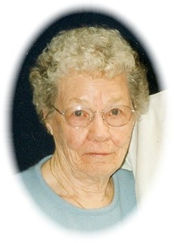
Viola Ruth Coulter Ware
| Birth | : | 18 Jul 1922 Jamestown, Stutsman County, North Dakota, USA |
| Death | : | 29 Mar 2015 Jordan, Garfield County, Montana, USA |
| Burial | : | Pioneer Cemetery, Jordan, Garfield County, USA |
| Coordinate | : | 47.3244019, -106.9238968 |
| Description | : | SOURCE: Death Certificate: '''''''''''''''''''''''''''' Source: Stevenson and Sons Funeral Home In the early morning hours of March 29, 2015, our beloved mother, grandmother, great-grandmother, and friend quietly died. Her passing was as she wished, in her sleep and in her own bed, in her own home. While we are mourning her loss, we are profoundly grateful for the many years we were blessed with her presence. Viola Ruth Coulter was born, the middle child of 5 children, to Joseph Samuel Coulter and Eva May Miller Coulter on July 18, 1922, in Jamestown, North Dakota. |
frequently asked questions (FAQ):
-
Where is Viola Ruth Coulter Ware's memorial?
Viola Ruth Coulter Ware's memorial is located at: Pioneer Cemetery, Jordan, Garfield County, USA.
-
When did Viola Ruth Coulter Ware death?
Viola Ruth Coulter Ware death on 29 Mar 2015 in Jordan, Garfield County, Montana, USA
-
Where are the coordinates of the Viola Ruth Coulter Ware's memorial?
Latitude: 47.3244019
Longitude: -106.9238968
Family Members:
Parent

Spouse
Siblings
Flowers:


Nearby Cemetories:
1. Pioneer Cemetery
Jordan, Garfield County, USA
Coordinate: 47.3244019, -106.9238968
2. Greenridge Cemetery
Jordan, Garfield County, USA
Coordinate: 47.3389015, -106.8946991
3. Hinther Cemetery
Garfield County, USA
Coordinate: 47.2685000, -107.0218000
4. Butte Creek Cemetery
Garfield County, USA
Coordinate: 47.4777985, -107.2341995
5. Steve Forks Cemetery
Garfield County, USA
Coordinate: 47.2627983, -107.3321991
6. Cohagen Cemetery
Cohagen, Garfield County, USA
Coordinate: 47.0772018, -106.6232986
7. Darnall-Armbruster-Hubbard Family Cemetery
Garfield County, USA
Coordinate: 47.6407000, -107.0645200
8. Neudorfer Cemetery
Jordan, Garfield County, USA
Coordinate: 47.2095000, -106.2772000
9. Hearts at Peace Cemetery
Brusett, Garfield County, USA
Coordinate: 47.5441900, -107.5399200
10. Wolf Cemetery
Garfield County, USA
Coordinate: 47.1528015, -107.5924988
11. Vanstel Cemetery
Rosebud County, USA
Coordinate: 46.7872009, -106.8942032
12. Haglunds Ritchie Cemetery
McCone County, USA
Coordinate: 47.3246994, -106.0639038
13. Biebers Cemetery
McCone County, USA
Coordinate: 47.2386100, -106.0348800
14. Biebers Cemetery
McCone County, USA
Coordinate: 47.2257600, -106.0220400
15. Watkins Cemetery
McCone County, USA
Coordinate: 47.1808014, -105.9811020
16. Coon Cemetery
Garfield County, USA
Coordinate: 47.3263790, -107.9323320
17. Gilfeather Cemetery
Benzien, Garfield County, USA
Coordinate: 47.2348310, -107.9476920
18. Fort Peck Cemetery
Valley County, USA
Coordinate: 48.0069008, -106.4599991
19. Rock Springs Cemetery
Rock Springs, Rosebud County, USA
Coordinate: 46.7847800, -106.1411500
20. Fort Peck Dam Disaster Memorial
Valley County, USA
Coordinate: 48.0083000, -106.4003000
21. Brockway Cemetery
McCone County, USA
Coordinate: 47.2963982, -105.7514038
22. Brost Cemetery
McCone County, USA
Coordinate: 47.2971992, -105.7457962
23. Galpin Cemetery
Valley County, USA
Coordinate: 48.0732994, -106.4692001
24. Sumatra Cemetery
Rosebud County, USA
Coordinate: 46.6136017, -107.5674973