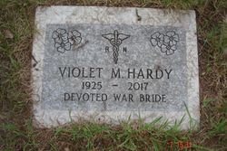
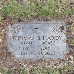
Violet Muriel Bertha Lawrence Hardy
| Birth | : | 28 Feb 1925 Canterbury, City of Canterbury, Kent, England |
| Death | : | 9 Feb 2017 |
| Burial | : | Kimberley Cemetery, Kimberley, East Kootenay Regional District, Canada |
| Coordinate | : | 49.6766700, -115.9746000 |
| Description | : | Violet was born in Canterbury Kent, England in 1925, she was the last in a large family. While Vi was working as a candy striper during the war she was "wooed" by a Canadian soldier named Thomas Hardy. Not long after they were married, and Iris was born. After the war was finished Vi and Iris made their way to Canada, landing in small town Rennie, Manitoba which was a big shock. Later the family moved to Cranbrook, and then to Kimberley, Vi and Tom finally settled on a farm in Meadowbrook where they lived for many years. Vi worked... Read More |
frequently asked questions (FAQ):
-
Where is Violet Muriel Bertha Lawrence Hardy's memorial?
Violet Muriel Bertha Lawrence Hardy's memorial is located at: Kimberley Cemetery, Kimberley, East Kootenay Regional District, Canada.
-
When did Violet Muriel Bertha Lawrence Hardy death?
Violet Muriel Bertha Lawrence Hardy death on 9 Feb 2017 in
-
Where are the coordinates of the Violet Muriel Bertha Lawrence Hardy's memorial?
Latitude: 49.6766700
Longitude: -115.9746000
Family Members:
Spouse
Flowers:
Nearby Cemetories:
1. Kimberley Cemetery
Kimberley, East Kootenay Regional District, Canada
Coordinate: 49.6766700, -115.9746000
2. Marysville Cemetery
Marysville, East Kootenay Regional District, Canada
Coordinate: 49.6386900, -115.9513300
3. Aqam Cemetery
Cranbrook, East Kootenay Regional District, Canada
Coordinate: 49.5833840, -115.7574800
4. Cranbrook New General Cemetery
Cranbrook, East Kootenay Regional District, Canada
Coordinate: 49.5118890, -115.7837250
5. Cranbrook Old General Cemetery
Cranbrook, East Kootenay Regional District, Canada
Coordinate: 49.5116630, -115.7826420
6. Westlawn Cemetery
Cranbrook, East Kootenay Regional District, Canada
Coordinate: 49.5112220, -115.7821910
7. Cranbrook Catholic Cemetery
Cranbrook, East Kootenay Regional District, Canada
Coordinate: 49.5114080, -115.7813930
8. Fort Steele Cemetery
Fort Steele, East Kootenay Regional District, Canada
Coordinate: 49.6260109, -115.6225662
9. Moyie Cemetery
Moyie, East Kootenay Regional District, Canada
Coordinate: 49.2743920, -115.8350350
10. Canal Flats Cemetery
Canal Flats, East Kootenay Regional District, Canada
Coordinate: 50.1617820, -115.8049420
11. Gray Creek Cemetery
Gray Creek, Central Kootenay Regional District, Canada
Coordinate: 49.6259540, -116.7854990
12. Crawford Bay Cemetery
Crawford Bay, Central Kootenay Regional District, Canada
Coordinate: 49.6945390, -116.8138077
13. Boswell Cemetery
Boswell, Central Kootenay Regional District, Canada
Coordinate: 49.4552000, -116.7615000
14. Sand Creek Cemetery
Jaffray, East Kootenay Regional District, Canada
Coordinate: 49.3362250, -115.2909390
15. Yahk Cemetery
Yahk, Central Kootenay Regional District, Canada
Coordinate: 49.0885510, -116.0776230
16. Goat River Cemetery
Creston, Central Kootenay Regional District, Canada
Coordinate: 49.1411200, -116.3992060
17. Ainsworth Cemetery
Ainsworth Hot Springs, Central Kootenay Regional District, Canada
Coordinate: 49.7333330, -116.9094190
18. Fernie Cemetery
Fernie, East Kootenay Regional District, Canada
Coordinate: 49.5002240, -115.0579050
19. East Fernie Cemetery
Fernie, East Kootenay Regional District, Canada
Coordinate: 49.5018590, -115.0566640
20. Saint Margaret's Cemetery
Fernie, East Kootenay Regional District, Canada
Coordinate: 49.4989900, -115.0550900
21. Balfour Cemetery
Balfour, Central Kootenay Regional District, Canada
Coordinate: 49.6283100, -116.9619100
22. Forest Lawn Cemetery
Creston, Central Kootenay Regional District, Canada
Coordinate: 49.0991400, -116.4626400
23. Kaslo Cemetery
Kaslo, Central Kootenay Regional District, Canada
Coordinate: 49.9113100, -116.9329100
24. Baynes Lake Cemetery
Baynes Lake, East Kootenay Regional District, Canada
Coordinate: 49.2369900, -115.2106000


