

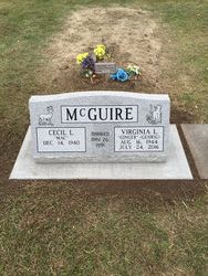
Virginia Lea “Ginger” Gehrig McGuire
| Birth | : | 16 Aug 1944 Harlan County, Nebraska, USA |
| Death | : | 24 Jul 2016 Holdrege, Phelps County, Nebraska, USA |
| Burial | : | Oxford Cemetery, Oxford, Harlan County, USA |
| Coordinate | : | 40.2580986, -99.6121979 |
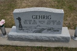
| Description | : | Funeral Services for Virginia L. McGuire were held on Saturday, July 30, 2016 at 10:30 a.m. at the Nelson-Bauer Funeral Home in Holdrege, Nebraska with Pastor Mike Szekely officiating. Burial was held in the Oxford Cemetery, following the service. Virginia Lea “Ginger” McGuire, 71 years of age, of Holdrege, Nebraska, passed away on Sunday, July 24, 2016 at Holdrege Memorial Homes. Ginger was born August 16, 1944 in rural Harlan County, Nebraska south of Republican City, on her grandparent’s farm, the second daughter born to George and Bessie (Whitney) Gehrig. Ginger resided at her parent’s farm, northeast of... Read More |
frequently asked questions (FAQ):
-
Where is Virginia Lea “Ginger” Gehrig McGuire's memorial?
Virginia Lea “Ginger” Gehrig McGuire's memorial is located at: Oxford Cemetery, Oxford, Harlan County, USA.
-
When did Virginia Lea “Ginger” Gehrig McGuire death?
Virginia Lea “Ginger” Gehrig McGuire death on 24 Jul 2016 in Holdrege, Phelps County, Nebraska, USA
-
Where are the coordinates of the Virginia Lea “Ginger” Gehrig McGuire's memorial?
Latitude: 40.2580986
Longitude: -99.6121979
Family Members:
Parent

Spouse
Flowers:


Nearby Cemetories:
1. Oxford Cemetery
Oxford, Harlan County, USA
Coordinate: 40.2580986, -99.6121979
2. Spring Grove Cemetery
Mascot, Harlan County, USA
Coordinate: 40.2775002, -99.5582962
3. Kellner Cemetery
Oxford, Furnas County, USA
Coordinate: 40.3215000, -99.6311000
4. Carter Cemetery
Orleans, Harlan County, USA
Coordinate: 40.2058000, -99.5143500
5. Sasse Cemetery
Orleans, Harlan County, USA
Coordinate: 40.1764900, -99.5545200
6. Homfeld Family Cemetery
Orleans, Harlan County, USA
Coordinate: 40.1658300, -99.5372300
7. Stamford Cemetery
Stamford, Harlan County, USA
Coordinate: 40.1469002, -99.5931015
8. Lennemann Cemetery
Orleans, Harlan County, USA
Coordinate: 40.1757800, -99.4988700
9. Highland Union Cemetery
Gosper County, USA
Coordinate: 40.3513990, -99.7172360
10. Edison Cemetery
Edison, Furnas County, USA
Coordinate: 40.2919006, -99.7902985
11. Union Cemetery
Beaver City, Furnas County, USA
Coordinate: 40.1469002, -99.7247009
12. Stump Cemetery
Furnas County, USA
Coordinate: 40.3478012, -99.7621994
13. Deaver Cemetery
Precept, Furnas County, USA
Coordinate: 40.1030998, -99.6489029
14. Zion Cemetery
Gosper County, USA
Coordinate: 40.4085999, -99.7005997
15. Shaw Cemetery
Phelps County, USA
Coordinate: 40.4303017, -99.5781021
16. Calvary Cemetery
Orleans, Harlan County, USA
Coordinate: 40.1377983, -99.4421997
17. Orleans Cemetery
Orleans, Harlan County, USA
Coordinate: 40.1330000, -99.4436700
18. Pleasant Hill Cemetery
Stamford, Harlan County, USA
Coordinate: 40.0730200, -99.6293800
19. Hoyt Cemetery
Orleans, Harlan County, USA
Coordinate: 40.1330190, -99.4316340
20. Industry Cemetery
Atlanta, Phelps County, USA
Coordinate: 40.4071999, -99.4419022
21. German Lutheran Cemetery
Harlan County, USA
Coordinate: 40.0461006, -99.5532990
22. Garfield Cemetery
Furnas County, USA
Coordinate: 40.2491989, -99.8992004
23. Mount Hope Cemetery
Beaver City, Furnas County, USA
Coordinate: 40.1333008, -99.8518982
24. Arapahoe Cemetery
Arapahoe, Furnas County, USA
Coordinate: 40.3239600, -99.8985500