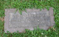
Virginia Lee Day Kern
| Birth | : | 4 Jul 1918 Washington, District of Columbia, District of Columbia, USA |
| Death | : | 30 Oct 1996 Saint Johnsbury, Caledonia County, Vermont, USA |
| Burial | : | Rodney Cemetery, Rodney, Mecosta County, USA |
| Coordinate | : | 43.6703491, -85.3264923 |
| Plot | : | Lot 911 Site 6 |
| Description | : | Although Virginia's tombstone gives her surname as Day, her death certificate states she was a widow and her surname at death was Kern. |
frequently asked questions (FAQ):
-
Where is Virginia Lee Day Kern's memorial?
Virginia Lee Day Kern's memorial is located at: Rodney Cemetery, Rodney, Mecosta County, USA.
-
When did Virginia Lee Day Kern death?
Virginia Lee Day Kern death on 30 Oct 1996 in Saint Johnsbury, Caledonia County, Vermont, USA
-
Where are the coordinates of the Virginia Lee Day Kern's memorial?
Latitude: 43.6703491
Longitude: -85.3264923
Family Members:
Parent
Flowers:
Nearby Cemetories:
1. Rodney Cemetery
Rodney, Mecosta County, USA
Coordinate: 43.6703491, -85.3264923
2. Martiny Township Cemetery
Martiny Township, Mecosta County, USA
Coordinate: 43.6852989, -85.3097000
3. Mount Hope Cemetery
Mecosta, Mecosta County, USA
Coordinate: 43.6260986, -85.2406006
4. Chippewa Lake Cemetery
Chippewa Township, Mecosta County, USA
Coordinate: 43.7494011, -85.2900009
5. Pine Plains Cemetery
Big Rapids, Mecosta County, USA
Coordinate: 43.6680984, -85.4436035
6. Olin Cemetery
Stanwood, Mecosta County, USA
Coordinate: 43.5879000, -85.3719500
7. 160th Avenue South Cemetery
Big Rapids, Mecosta County, USA
Coordinate: 43.7436111, -85.4038889
8. Dye Cemetery
Mecosta, Mecosta County, USA
Coordinate: 43.6646004, -85.1864929
9. 21 Mile South Cemetery
Grant Center, Mecosta County, USA
Coordinate: 43.7713000, -85.3875000
10. 21 Mile North Cemetery
Grant Center, Mecosta County, USA
Coordinate: 43.7710000, -85.3885000
11. Morgan Cemetery
Wheatland Township, Mecosta County, USA
Coordinate: 43.6150017, -85.1932983
12. Eaton Cemetery
Barryton, Mecosta County, USA
Coordinate: 43.7564011, -85.2202988
13. Saint Andrews Episcopal Church Columbarium
Big Rapids, Mecosta County, USA
Coordinate: 43.6946130, -85.4835020
14. Sparks Cemetery
Chippewa Township, Mecosta County, USA
Coordinate: 43.7724991, -85.2442017
15. Highland View Cemetery
Big Rapids, Mecosta County, USA
Coordinate: 43.7032318, -85.4905319
16. Morton Township Cemetery
Mecosta, Mecosta County, USA
Coordinate: 43.5710983, -85.2249985
17. Saint Michaels Cemetery
Remus, Mecosta County, USA
Coordinate: 43.5959587, -85.1854782
18. Quigley Cemetery
Deerfield Township, Mecosta County, USA
Coordinate: 43.5536003, -85.3930969
19. Stanwood Cemetery
Stanwood, Mecosta County, USA
Coordinate: 43.5769691, -85.4444885
20. Mecosta County Farm Cemetery
Mecosta Township, Mecosta County, USA
Coordinate: 43.5738200, -85.4447300
21. Ladner Cemetery
Stanwood, Mecosta County, USA
Coordinate: 43.6206017, -85.4918976
22. Pioneer Cemetery
Grant Township, Mecosta County, USA
Coordinate: 43.8005981, -85.3439026
23. Altona Cemetery
Altona, Mecosta County, USA
Coordinate: 43.5393982, -85.3003006
24. Higbee Cemetery
Stanwood, Mecosta County, USA
Coordinate: 43.5394707, -85.3921890


