
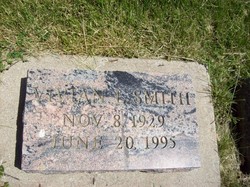
Vivian Louise Black Smith
| Birth | : | 8 Nov 1929 Sheridan, Worth County, Missouri, USA |
| Death | : | 20 Jun 1995 Maryville, Nodaway County, Missouri, USA |
| Burial | : | Trinity Lutheran Church Cemetery, Elloree, Orangeburg County, USA |
| Coordinate | : | 33.5603720, -80.5659850 |
| Plot | : | Central A (4), Row 6 |
| Description | : | Vivian (Black) Smith, 65, Maryville, died Tuesday, June 20, 1995, at a Maryville Health-care center. Born in Sheridan, Missouri, on November 8, 1929, Mrs. Smith had resided in the Maryville area all of her life. She had co-owned and operated D & S Western Sales in Maryville and had been a homemaker. Mrs. Smith, a Maryville high school graduate, was a member of the First united Methodist Church, Maryville, where she was active in the choir, and bridge clubs. On February 8, 1969, she married William M. "Bill" Smith in Mound City, Missouri. He survives of the home in Maryville. Mrs. Smith... Read More |
frequently asked questions (FAQ):
-
Where is Vivian Louise Black Smith's memorial?
Vivian Louise Black Smith's memorial is located at: Trinity Lutheran Church Cemetery, Elloree, Orangeburg County, USA.
-
When did Vivian Louise Black Smith death?
Vivian Louise Black Smith death on 20 Jun 1995 in Maryville, Nodaway County, Missouri, USA
-
Where are the coordinates of the Vivian Louise Black Smith's memorial?
Latitude: 33.5603720
Longitude: -80.5659850
Family Members:
Parent

Spouse

Siblings
Flowers:


Nearby Cemetories:
1. Union AME Church Cemetery
Calhoun County, USA
Coordinate: 33.5840910, -80.5575110
2. Bookhart Cemetery
Elloree, Orangeburg County, USA
Coordinate: 33.5485992, -80.5924988
3. Magrill Family Cemetery
Calhoun County, USA
Coordinate: 33.5601790, -80.5354270
4. Santee First Baptist Cemetery
Elloree, Orangeburg County, USA
Coordinate: 33.5553700, -80.6018080
5. Elloree Hillcrest Cemetery
Elloree, Orangeburg County, USA
Coordinate: 33.5608720, -80.6099720
6. Browning Branch Cemetery
Elloree, Orangeburg County, USA
Coordinate: 33.5231820, -80.5632140
7. New Faith Community Church Cemetery
Elloree, Orangeburg County, USA
Coordinate: 33.5229150, -80.5477570
8. Mount Zion AME Church Cemetery
Creston, Calhoun County, USA
Coordinate: 33.5689940, -80.6151050
9. Jerusalem Cemetery
Elloree, Orangeburg County, USA
Coordinate: 33.5102340, -80.5447570
10. Haynes Chapel AME Church Cemetery
Cameron, Calhoun County, USA
Coordinate: 33.6130110, -80.5751970
11. Mount Hebron Baptist Church Cemetery
Santee, Orangeburg County, USA
Coordinate: 33.5028570, -80.5381980
12. Parlerville A.M.E. Church Cemetery
Santee, Orangeburg County, USA
Coordinate: 33.5208030, -80.5039540
13. Bodrick Cemetery
Lone Star, Calhoun County, USA
Coordinate: 33.6245880, -80.5891440
14. Mount Pisgah Church Cemetery
Santee, Orangeburg County, USA
Coordinate: 33.5182200, -80.5027480
15. Hungerpiller Family Cemetery
Elloree, Orangeburg County, USA
Coordinate: 33.5049010, -80.6123380
16. Cedar Grove Baptist Church Cemetery
Lone Star, Calhoun County, USA
Coordinate: 33.6259320, -80.5947950
17. Hart Graveyard
Holly Hill, Orangeburg County, USA
Coordinate: 33.4918320, -80.5470820
18. Irick Cemetery
Lone Star, Calhoun County, USA
Coordinate: 33.6283580, -80.5924100
19. Smith-Dantzler Cemetery
Elloree, Orangeburg County, USA
Coordinate: 33.4941130, -80.6052520
20. Whitmore, Avinger, Norris, Felder Cemetery
Elloree, Orangeburg County, USA
Coordinate: 33.4870530, -80.5532600
21. Granger Baptist Church Cemetery
Elloree, Orangeburg County, USA
Coordinate: 33.4909840, -80.6030410
22. Gresham Cemetery
Orangeburg County, USA
Coordinate: 33.4906006, -80.6031036
23. Pine Grove Lutheran Church Cemetery
Lone Star, Calhoun County, USA
Coordinate: 33.6349610, -80.6016470
24. McGrew Cemetery
Elloree, Orangeburg County, USA
Coordinate: 33.4859880, -80.6027150