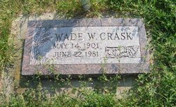
Wade W Crask
| Birth | : | 14 May 1901 Trinidad, Las Animas County, Colorado, USA |
| Death | : | 22 Jun 1981 Fruitland, Stevens County, Washington, USA |
| Burial | : | Sacred Heart Catholic Cemetery, Costilla, Taos County, USA |
| Coordinate | : | 36.9882000, -105.5402000 |
| Description | : | Crask, Wade W., ( b. May 14, 1901, d. Jun 22, 1981) “Graveside services for Wade W. Crask, former Davenport area farmer, are to be held Friday, June 26 at 2 p.m. at the Greenwood Park Cemetery in Hunters, WA. He died June 22 in Spokane, where he resided at a convalescent home for the past two years. He was born May 14, 1901 in Trinidad , CO, and moved to WA in 1913 to settle near Mansfield. In 1924 he moved near Davenport to farm until 1943 when he moved to Hunters. He lived... Read More |
frequently asked questions (FAQ):
-
Where is Wade W Crask's memorial?
Wade W Crask's memorial is located at: Sacred Heart Catholic Cemetery, Costilla, Taos County, USA.
-
When did Wade W Crask death?
Wade W Crask death on 22 Jun 1981 in Fruitland, Stevens County, Washington, USA
-
Where are the coordinates of the Wade W Crask's memorial?
Latitude: 36.9882000
Longitude: -105.5402000
Family Members:
Parent
Spouse
Siblings
Children
Flowers:
Nearby Cemetories:
1. Sacred Heart Catholic Cemetery
Costilla, Taos County, USA
Coordinate: 36.9882000, -105.5402000
2. Garcia Presbyterian Cemetery
Garcia, Costilla County, USA
Coordinate: 37.0042000, -105.5437000
3. Garcia Pentecostal Cemetery
Garcia, Costilla County, USA
Coordinate: 37.0099470, -105.5430150
4. Garcia Cemetery
Costilla County, USA
Coordinate: 37.0101360, -105.5439600
5. Jaroso Cemetery
Costilla County, USA
Coordinate: 37.0179400, -105.6274800
6. Amalia Cemetery
Amalia, Taos County, USA
Coordinate: 36.9452000, -105.4571000
7. Eastdale Cemetery
Eastdale, Costilla County, USA
Coordinate: 37.0293420, -105.6512270
8. Mesita Cemetery
Mesita, Costilla County, USA
Coordinate: 37.1038000, -105.6029000
9. Sunshine Valley Cemetery
Taos County, USA
Coordinate: 36.8650017, -105.6402969
10. Latir Cemetery
Taos County, USA
Coordinate: 36.8083000, -105.5742035
11. San Francisco Cemetery
Costilla County, USA
Coordinate: 37.1062000, -105.3510000
12. Los Fuertes Cemetery
San Pablo, Costilla County, USA
Coordinate: 37.1342000, -105.3686000
13. San Acacio New Cemetery
San Acacio, Costilla County, USA
Coordinate: 37.1930000, -105.5097000
14. Chama Assemblies of God Cemetery
Chama, Costilla County, USA
Coordinate: 37.1545460, -105.3730070
15. Chama Cemetery
Chama, Costilla County, USA
Coordinate: 37.1561012, -105.3719025
16. San Acacio Old Cemetery
San Acacio, Costilla County, USA
Coordinate: 37.2018000, -105.5079000
17. Old Chama Catholic Cemetery
Chama, Costilla County, USA
Coordinate: 37.1620400, -105.3689300
18. San Pedro Cemetery
San Luis, Costilla County, USA
Coordinate: 37.1893997, -105.3897018
19. Cerro Protestant Cemetery
Cerro, Taos County, USA
Coordinate: 36.7565000, -105.6005000
20. San Luis Cemetery
San Luis, Costilla County, USA
Coordinate: 37.2013000, -105.4095000
21. San Luis Old Catholic Cemetery
San Luis, Costilla County, USA
Coordinate: 37.2014800, -105.4073200
22. Apostolic Church Cemetery
San Luis, Costilla County, USA
Coordinate: 37.2015320, -105.4058660
23. Church of God in Christ Cemetery
San Luis, Costilla County, USA
Coordinate: 37.2014980, -105.4048260
24. Chapel of Nuestra Senora de Guadalupe Cemetery
Cerro, Taos County, USA
Coordinate: 36.7519000, -105.6079000

