
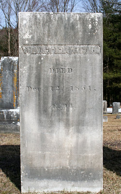
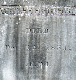

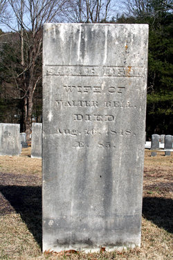
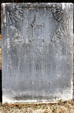
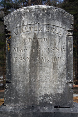
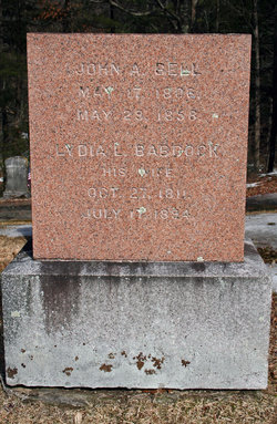
Walter Bell
| Birth | : | 18 May 1757 Roxbury, Suffolk County, Massachusetts, USA |
| Death | : | 12 Dec 1851 Colrain, Franklin County, Massachusetts, USA |
| Burial | : | Saint Peters Catholic Cemetery, Upper Sandusky, Wyandot County, USA |
| Coordinate | : | 40.8375015, -83.2855988 |
| Description | : | Age 18 enlisted April 4, 1776 as a private in Capt. Robert Cochran's Company and served 9 months. Re-enlisted Oct. 1, 1777 as a private in Capt. Hugh McClellan's Company. He was allowed a Revolutionary War Pension. He was 75 at the time and recalled marching from Colrain to Albany,NY. He marched on to Fort George and Ticonderoga. On to Fort George, there becoming quite ill. His father, Thomas came and carried him home. He recovered and was called back, but his father hired a man, John Harrison, to finish his 9 months. He did a second tour and was... Read More |
frequently asked questions (FAQ):
-
Where is Walter Bell's memorial?
Walter Bell's memorial is located at: Saint Peters Catholic Cemetery, Upper Sandusky, Wyandot County, USA.
-
When did Walter Bell death?
Walter Bell death on 12 Dec 1851 in Colrain, Franklin County, Massachusetts, USA
-
Where are the coordinates of the Walter Bell's memorial?
Latitude: 40.8375015
Longitude: -83.2855988
Family Members:
Parent
Spouse
Children

Flowers:


Nearby Cemetories:
1. Saint Peters Catholic Cemetery
Upper Sandusky, Wyandot County, USA
Coordinate: 40.8375015, -83.2855988
2. Old Mission Cemetery
Upper Sandusky, Wyandot County, USA
Coordinate: 40.8356000, -83.2796300
3. Old Indian Burial Grounds
Upper Sandusky, Wyandot County, USA
Coordinate: 40.8265540, -83.2779740
4. Nine Oaks Cemetery
Upper Sandusky, Wyandot County, USA
Coordinate: 40.8472716, -83.2973859
5. Sandusky Battlefield
Upper Sandusky, Wyandot County, USA
Coordinate: 40.8347220, -83.2663890
6. Peters Cemetery
Upper Sandusky, Wyandot County, USA
Coordinate: 40.8122220, -83.2794440
7. Chief Tarhe Monument
Upper Sandusky, Wyandot County, USA
Coordinate: 40.8619310, -83.2673790
8. Upper Sandusky Mausoleum
Wyandot County, USA
Coordinate: 40.8077030, -83.2843710
9. Oak Hill Cemetery
Upper Sandusky, Wyandot County, USA
Coordinate: 40.7952995, -83.2758026
10. Haas Cemetery
Upper Sandusky, Wyandot County, USA
Coordinate: 40.8259090, -83.2288750
11. Reber Cemetery
Upper Sandusky, Wyandot County, USA
Coordinate: 40.7937600, -83.2672450
12. Rock Run Cemetery
Upper Sandusky, Wyandot County, USA
Coordinate: 40.8217010, -83.2225037
13. Infirmary Cemetery
Upper Sandusky, Wyandot County, USA
Coordinate: 40.8795400, -83.3221470
14. North Salem Lutheran Church Cemetery
Upper Sandusky, Wyandot County, USA
Coordinate: 40.8756100, -83.3471400
15. McClain Cemetery
Upper Sandusky, Wyandot County, USA
Coordinate: 40.7846929, -83.2419017
16. Smithville Cemetery
Smithville, Wyandot County, USA
Coordinate: 40.8914500, -83.2368600
17. Saint Joseph's Cemetery
Lovell, Wyandot County, USA
Coordinate: 40.8767200, -83.3574200
18. Salem Cemetery
Eden Township, Wyandot County, USA
Coordinate: 40.8408230, -83.1929050
19. Ulrich Cemetery
Wyandot County, USA
Coordinate: 40.8480988, -83.1913986
20. Krock Cemetery
Kirby, Wyandot County, USA
Coordinate: 40.8227997, -83.3806000
21. Emanuel United Church of Christ Cemetery
Upper Sandusky, Wyandot County, USA
Coordinate: 40.7897980, -83.2073110
22. Hendrickson Cemetery
Upper Sandusky, Wyandot County, USA
Coordinate: 40.7667236, -83.3243637
23. Gilliland Cemetery
Edenville, Wyandot County, USA
Coordinate: 40.8331100, -83.1793600
24. Union Church Cemetery
Upper Sandusky, Wyandot County, USA
Coordinate: 40.8774185, -83.1894226