

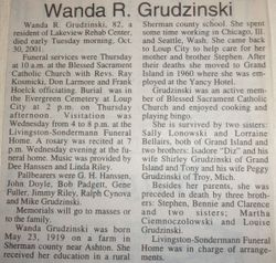
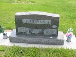
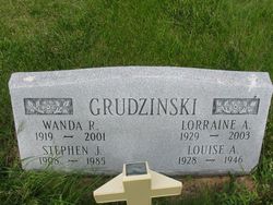
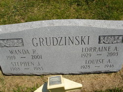
Wanda R. Grudzinski
| Birth | : | 23 May 1919 Sherman County, Nebraska, USA |
| Death | : | 30 Oct 2001 Grand Island, Hall County, Nebraska, USA |
| Burial | : | Old Pickens Cemetery, Old Pickens, Oconee County, USA |
| Coordinate | : | 34.7910995, -82.8867035 |
| Description | : | Daughter of Anton & Anna (Moraczewski) Grudzinski. |
frequently asked questions (FAQ):
-
Where is Wanda R. Grudzinski's memorial?
Wanda R. Grudzinski's memorial is located at: Old Pickens Cemetery, Old Pickens, Oconee County, USA.
-
When did Wanda R. Grudzinski death?
Wanda R. Grudzinski death on 30 Oct 2001 in Grand Island, Hall County, Nebraska, USA
-
Where are the coordinates of the Wanda R. Grudzinski's memorial?
Latitude: 34.7910995
Longitude: -82.8867035
Family Members:
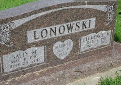
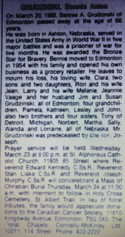
Parent
Siblings


Flowers:


Nearby Cemetories:
1. Old Pickens Cemetery
Old Pickens, Oconee County, USA
Coordinate: 34.7910995, -82.8867035
2. Craig Memorial Cemetery
Old Pickens, Oconee County, USA
Coordinate: 34.7914848, -82.8876801
3. Little-Jenkins Cemetery
Oconee County, USA
Coordinate: 34.7883730, -82.8916650
4. Powers Family Cemetery
Pickens County, USA
Coordinate: 34.7966500, -82.8755170
5. Morgan Family Cemetery
Central, Pickens County, USA
Coordinate: 34.7825670, -82.8750170
6. Cary Cemetery
Oconee County, USA
Coordinate: 34.7700005, -82.8966980
7. Kings Grove Baptist Church Cemetery
Central, Pickens County, USA
Coordinate: 34.7829000, -82.8574000
8. Old Kings Grove Baptist Church Cemetery
Central, Pickens County, USA
Coordinate: 34.7648330, -82.8737500
9. New Foundation Cemetery
Oconee County, USA
Coordinate: 34.7668991, -82.9077988
10. Robert Morgan-Cannon Family
Central, Pickens County, USA
Coordinate: 34.7820850, -82.8521350
11. High Falls Cemetery
Oconee County, USA
Coordinate: 34.8013992, -82.9310989
12. Gap Hill Baptist Church Cemetery
Six Mile, Pickens County, USA
Coordinate: 34.8293991, -82.8613968
13. Pleasant Hill Baptist Church Cemetery
Central, Pickens County, USA
Coordinate: 34.7633018, -82.8324966
14. Mount Olivet Wesleyan Church Cemetery
Six Mile, Pickens County, USA
Coordinate: 34.8121430, -82.8242680
15. Six Mile Baptist Church Cemetery
Six Mile, Pickens County, USA
Coordinate: 34.8074989, -82.8214035
16. Church of God of Prophecy Cemetery
Six Mile, Pickens County, USA
Coordinate: 34.7962860, -82.8183080
17. Dodd Family Cemetery
Westminster, Oconee County, USA
Coordinate: 34.7327499, -82.8743134
18. Stamp Creek Cemetery
Oconee County, USA
Coordinate: 34.8417015, -82.9250031
19. Hunnicutt Family Cemetery
Salem, Oconee County, USA
Coordinate: 34.8339350, -82.9378370
20. New Hope Cemetery
Seneca, Oconee County, USA
Coordinate: 34.7667007, -82.9543991
21. Stephens Family Cemetery
Pickens, Pickens County, USA
Coordinate: 34.8521060, -82.8735060
22. Lawrence Chapel United Methodist Church Cemetery
Central, Pickens County, USA
Coordinate: 34.7447014, -82.8360977
23. Cedar Hill Holiness Church Cemetery
Six Mile, Pickens County, USA
Coordinate: 34.8324530, -82.8202970
24. Keowee Baptist Church Cemetery
Six Mile, Pickens County, USA
Coordinate: 34.8613830, -82.8759000