
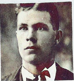

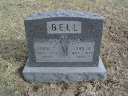
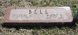
Wardie Elmer Bell
| Birth | : | 16 May 1883 Ringer, Miami County, Kansas, USA |
| Death | : | 28 Aug 1948 Eureka, Greenwood County, Kansas, USA |
| Burial | : | Park View Cemetery, Manteca, San Joaquin County, USA |
| Coordinate | : | 37.8617249, -121.2238312 |
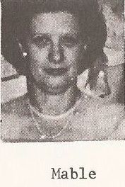
| Description | : | Warder Elmer Bell, son of John Willis and Emma Bell was born May 16, 1883 at Paola, Kans., and departed this life at his home in Eureka, Kansas, on August 28, 1948 at the age of 65 years, three months and ten days. Although he had been in failing health for some time, death came unexpectedly. He spent a busy afternoon in his yard and then shortly after retiring for the night, death came. On August 22, 1904, he was united in marriage to Miss Josephine McHone, and to this union four children were born, all of whom survive. After... Read More |
frequently asked questions (FAQ):
-
Where is Wardie Elmer Bell's memorial?
Wardie Elmer Bell's memorial is located at: Park View Cemetery, Manteca, San Joaquin County, USA.
-
When did Wardie Elmer Bell death?
Wardie Elmer Bell death on 28 Aug 1948 in Eureka, Greenwood County, Kansas, USA
-
Where are the coordinates of the Wardie Elmer Bell's memorial?
Latitude: 37.8617249
Longitude: -121.2238312
Family Members:
Parent

Spouse
Siblings


Children
Flowers:


Nearby Cemetories:
1. Congregation Adas Yeshuran of Stockton Cemetery
French Camp, San Joaquin County, USA
Coordinate: 37.8784065, -121.2740784
2. Congregation of Ahavas Achim Cemetery
French Camp, San Joaquin County, USA
Coordinate: 37.8778419, -121.2753067
3. Chinese Cemetery
French Camp, San Joaquin County, USA
Coordinate: 37.8819962, -121.2805862
4. East Union Cemetery
Manteca, San Joaquin County, USA
Coordinate: 37.8114014, -121.2350006
5. Atlanta Cemetery
Five Corners, San Joaquin County, USA
Coordinate: 37.8270035, -121.1420135
6. Collegeville Cemetery
Collegeville, San Joaquin County, USA
Coordinate: 37.9044800, -121.1466141
7. Citizens Cemetery
Stockton, San Joaquin County, USA
Coordinate: 37.9559410, -121.2769120
8. Thomas Lindsay Gravesite
San Joaquin County, USA
Coordinate: 37.9573110, -121.2918430
9. David Kelsey Gravesite
Stockton, San Joaquin County, USA
Coordinate: 37.9573110, -121.2918430
10. Temple Israel Cemetery
Stockton, San Joaquin County, USA
Coordinate: 37.9640541, -121.2784348
11. Stockton State Hospital Cemetery
Stockton, San Joaquin County, USA
Coordinate: 37.9663110, -121.2846850
12. San Joaquin Catholic Cemetery
Stockton, San Joaquin County, USA
Coordinate: 37.9707830, -121.2850190
13. Casa Bonita Mausoleum
Stockton, San Joaquin County, USA
Coordinate: 37.9752340, -121.2877800
14. Stockton Woodland Mausoleum
Stockton, San Joaquin County, USA
Coordinate: 37.9762400, -121.2878000
15. Stockton Rural Cemetery
Stockton, San Joaquin County, USA
Coordinate: 37.9794006, -121.2869034
16. Saint John's Catholic Cemetery
Escalon, San Joaquin County, USA
Coordinate: 37.7994537, -121.0705185
17. Central United Methodist Church Columbarium
Stockton, San Joaquin County, USA
Coordinate: 37.9825710, -121.3078170
18. Ripon Cemetery
Ripon, San Joaquin County, USA
Coordinate: 37.7420311, -121.1238708
19. Highland View Memorial Gardens
Farmington, San Joaquin County, USA
Coordinate: 37.9242935, -121.0008621
20. Linden Cemetery
Linden, San Joaquin County, USA
Coordinate: 38.0226707, -121.0889053
21. Tracy Mausoleum
Tracy, San Joaquin County, USA
Coordinate: 37.7250214, -121.4150696
22. Tracy Public Cemetery
Tracy, San Joaquin County, USA
Coordinate: 37.7251358, -121.4189453
23. Wood Colony Cemetery
Salida, Stanislaus County, USA
Coordinate: 37.6893730, -121.0682144
24. Good Shepherd Catholic Cemetery
Modesto, Stanislaus County, USA
Coordinate: 37.6853130, -121.0672890