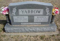
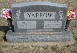
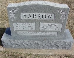
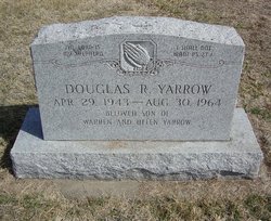
Warren “Boots” Yarrow
| Birth | : | 8 Sep 1915 Clay County, Kansas, USA |
| Death | : | 15 Apr 2006 Wakefield, Clay County, Kansas, USA |
| Burial | : | Brush Creek Cemetery, Brush Creek, Smith County, USA |
| Coordinate | : | 36.1239014, -86.0306015 |
| Description | : | Warren "Boots" Yarrow, 90, died Saturday, April 15, 2006, in Wakefield; born Sept. 8, 1915, in Clay County, the son of Alfred W. and Sarah Elizabeth (Jevon) Yarrow; married Helen Rider April 15, 1938; she preceded him in death Nov. 5, 2003; also preceded in death by a son, Douglas Yarrow, one brother, one sister and one grandson; survivors include one son, Keith Yarrow and wife Louise of Wakefield; one daughter, Janet Carswell and husband Gayle of Ellsworth; one sister, Hazel Smith of Omaha, Neb.; five grandchildren; and seven great-grandchildren; burial in Mizpah Cemetery. |
frequently asked questions (FAQ):
-
Where is Warren “Boots” Yarrow's memorial?
Warren “Boots” Yarrow's memorial is located at: Brush Creek Cemetery, Brush Creek, Smith County, USA.
-
When did Warren “Boots” Yarrow death?
Warren “Boots” Yarrow death on 15 Apr 2006 in Wakefield, Clay County, Kansas, USA
-
Where are the coordinates of the Warren “Boots” Yarrow's memorial?
Latitude: 36.1239014
Longitude: -86.0306015
Family Members:
Parent
Spouse
Siblings
Children
Flowers:
Nearby Cemetories:
1. Brush Creek Cemetery
Brush Creek, Smith County, USA
Coordinate: 36.1239014, -86.0306015
2. Brush Creek Memorial Gardens
Brush Creek, Smith County, USA
Coordinate: 36.1231950, -86.0295580
3. Fry Cemetery
Brush Creek, Smith County, USA
Coordinate: 36.1257390, -86.0308940
4. Brush Creek Primitive Baptist Church Cemetery
Brush Creek, Smith County, USA
Coordinate: 36.1217400, -86.0279700
5. Litchford Cemetery
Brush Creek, Smith County, USA
Coordinate: 36.1216500, -86.0278800
6. Brush Creek Missionary Baptist Church Cemetery
Brush Creek, Smith County, USA
Coordinate: 36.1212400, -86.0282400
7. Thomason Cemetery
Brush Creek, Smith County, USA
Coordinate: 36.1199000, -86.0363400
8. Allen Cemetery
Brush Creek, Smith County, USA
Coordinate: 36.1296260, -86.0239150
9. Davis Cemetery
Brush Creek, Smith County, USA
Coordinate: 36.1326670, -86.0321670
10. Atwood Cemetery
Brush Creek, Smith County, USA
Coordinate: 36.1143200, -86.0308000
11. Davis Cemetery
Brush Creek, Smith County, USA
Coordinate: 36.1343994, -86.0317001
12. Barnett Cemetery
Brush Creek, Smith County, USA
Coordinate: 36.1345730, -86.0345690
13. Barnett Cemetery
Brush Creek, Smith County, USA
Coordinate: 36.1362240, -86.0303250
14. Rodgers Cemetery
Brush Creek, Smith County, USA
Coordinate: 36.1254600, -86.0139000
15. Saulmon Cemetery
Brush Creek, Smith County, USA
Coordinate: 36.1282040, -86.0511660
16. Davis Cemetery
Brush Creek, Smith County, USA
Coordinate: 36.1068600, -86.0280000
17. Hall Cemetery
Brush Creek, Smith County, USA
Coordinate: 36.1200760, -86.0094090
18. Phillips Cemetery
Brush Creek, Smith County, USA
Coordinate: 36.1349983, -86.0136032
19. Creaghead Cemetery
Brush Creek, Smith County, USA
Coordinate: 36.1064900, -86.0427060
20. Bradley Cemetery
Brush Creek, Smith County, USA
Coordinate: 36.1210400, -86.0048100
21. Dowell-Moore Cemetery
Smith County, USA
Coordinate: 36.1250670, -86.0043450
22. Smartt Cemetery
Brush Creek, Smith County, USA
Coordinate: 36.1442800, -86.0428000
23. Brown Cemetery
Brush Creek, Smith County, USA
Coordinate: 36.1003000, -86.0310600
24. Courtney Cemetery
Brush Creek, Smith County, USA
Coordinate: 36.1046300, -86.0475830

