

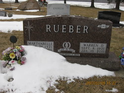
Warren Douglas Rueber
| Birth | : | 8 Sep 1921 Maynard, Fayette County, Iowa, USA |
| Death | : | 19 Jan 2011 New Hampton, Chickasaw County, Iowa, USA |
| Burial | : | Saint John's Lutheran Cemetery, Germany Township, Adams County, USA |
| Coordinate | : | 39.7434000, -77.1030000 |
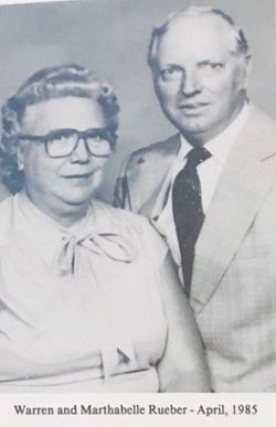
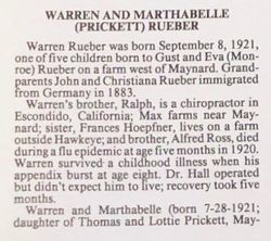
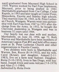
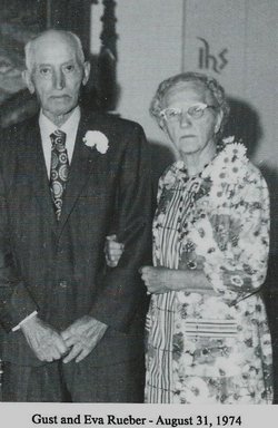
| Description | : | Warren Douglas Rueber was born on September 8, 1921, one of five children born to Gustav and Eva (Monroe) Rueber on a farm west of Maynard in Harlan Township, Fayette County, Iowa. He was baptized Sept. 9, 1921 by Rev. Fred Freutz and confirmed in 1935 by Rev. Otto C. Schultz at St. Peter Lutheran Church in Westgate, Iowa. He attended St. Peter Lutheran Parochial School and graduated from Maynard High School in 1939. Warren worked for Earl Foss Implement in Maynard prior to being drafted into the Army on Aug. 20, 1942. He served for four years at Camp... Read More |
frequently asked questions (FAQ):
-
Where is Warren Douglas Rueber's memorial?
Warren Douglas Rueber's memorial is located at: Saint John's Lutheran Cemetery, Germany Township, Adams County, USA.
-
When did Warren Douglas Rueber death?
Warren Douglas Rueber death on 19 Jan 2011 in New Hampton, Chickasaw County, Iowa, USA
-
Where are the coordinates of the Warren Douglas Rueber's memorial?
Latitude: 39.7434000
Longitude: -77.1030000
Family Members:
Parent

Spouse

Siblings
Children

Flowers:


Nearby Cemetories:
1. Saint John's Lutheran Cemetery
Germany Township, Adams County, USA
Coordinate: 39.7434000, -77.1030000
2. Mount Carmel Cemetery
Littlestown, Adams County, USA
Coordinate: 39.7397003, -77.0892029
3. Saint Aloysius Cemetery
Germany Township, Adams County, USA
Coordinate: 39.7364006, -77.0793991
4. Christ United Church of Christ Cemetery
Union Township, Adams County, USA
Coordinate: 39.7566681, -77.0558319
5. Saint James Reformed Cemetery
Mount Joy Township, Adams County, USA
Coordinate: 39.7312000, -77.1583000
6. Hostetters Meeting House Cemetery
Union Township, Adams County, USA
Coordinate: 39.7827000, -77.0580000
7. Piney Creek Church of the Brethren Cemetery
Taneytown, Carroll County, USA
Coordinate: 39.7033005, -77.1536026
8. Saint Luke's Lutheran Church Cemetery
Mount Pleasant Township, Adams County, USA
Coordinate: 39.8006150, -77.1200140
9. Barts-Centenary United Methodist Church Cemetery
Union Township, Adams County, USA
Coordinate: 39.7393000, -77.0264000
10. Two Taverns Cemetery
Mount Joy Township, Adams County, USA
Coordinate: 39.7789000, -77.1676000
11. Hanover Shoe Farms Equine Cemetery
Hanover, York County, USA
Coordinate: 39.7691060, -77.0257730
12. Saint Joseph the Worker Catholic Church Cemetery
Bonneauville, Adams County, USA
Coordinate: 39.8106000, -77.1355000
13. Saint Marys Cemetery
Silver Run, Carroll County, USA
Coordinate: 39.6844100, -77.0490800
14. Saint Joseph Academy Cemetery
McSherrystown, Adams County, USA
Coordinate: 39.7984000, -77.0239900
15. Elizabeth Horn Gravesite
Arters Mill, Carroll County, USA
Coordinate: 39.6646700, -77.0717900
16. Sunrise Cemetery
Harney, Carroll County, USA
Coordinate: 39.7125015, -77.2031021
17. Southern Low Dutch Cemetery
Mount Pleasant Township, Adams County, USA
Coordinate: 39.8068660, -77.1742750
18. Saint Mark's Reformed Cemetery
Mount Joy Township, Adams County, USA
Coordinate: 39.7918000, -77.1925000
19. Mountain View Cemetery
Harney, Carroll County, USA
Coordinate: 39.7196500, -77.2098600
20. Piney Creek Reformed Presbyterian Church Cemetery
Taneytown, Carroll County, USA
Coordinate: 39.6984500, -77.1977600
21. Pine Bank Cemetery
Mount Joy Township, Adams County, USA
Coordinate: 39.7761002, -77.2080994
22. Conewago Chapel Basilica Cemetery
Conewago Township, Adams County, USA
Coordinate: 39.8187714, -77.0360794
23. Saint Vincents Catholic Cemetery
Conewago Township, Adams County, USA
Coordinate: 39.7988150, -77.0082820
24. Mount Joy Cemetery
Mount Joy Township, Adams County, USA
Coordinate: 39.7479000, -77.2228000