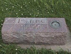
Wilbur Arthur “Bud” Parks
| Birth | : | 1 Apr 1925 Le Mars, Plymouth County, Iowa, USA |
| Death | : | 21 Nov 1962 Nemaha, Sac County, Iowa, USA |
| Burial | : | Paxton Center Cemetery, Paxton, Worcester County, USA |
| Coordinate | : | 42.3128900, -71.9277700 |
| Description | : | 1962 Nov 23, Carroll Daily Times Herald, P5, Carroll, Iowa Wilbur Arthur Parks Nemaha - Funeral services for Wilbur Arthur Parks, 37, Nemaha farmer who was fatally injured Wednesday in a tractor accident, were held at 2 p.m. Friday, Nov. 23, at the Methodist Church here. The Rev. P. Julian Daba officiated; and interment was in the Nemaha Cemetery, under direction of the Farber and Otteman Funeral Home. Donald Toomer was vocal soloist, accompanied by Mrs. Toomer. Pallbearers were Glen Reeves, Darrell Dempster, Keith Hines, Gerald Hines, Marvin Mooney and Kenneth Hamm. Mr. Parks was killed... Read More |
frequently asked questions (FAQ):
-
Where is Wilbur Arthur “Bud” Parks's memorial?
Wilbur Arthur “Bud” Parks's memorial is located at: Paxton Center Cemetery, Paxton, Worcester County, USA.
-
When did Wilbur Arthur “Bud” Parks death?
Wilbur Arthur “Bud” Parks death on 21 Nov 1962 in Nemaha, Sac County, Iowa, USA
-
Where are the coordinates of the Wilbur Arthur “Bud” Parks's memorial?
Latitude: 42.3128900
Longitude: -71.9277700
Family Members:
Parent
Spouse
Siblings
Flowers:
Nearby Cemetories:
1. Paxton Center Cemetery
Paxton, Worcester County, USA
Coordinate: 42.3128900, -71.9277700
2. Worcester County Memorial Park
Paxton, Worcester County, USA
Coordinate: 42.3245697, -71.9308777
3. Mooreland Cemetery
Paxton, Worcester County, USA
Coordinate: 42.3280800, -71.9321000
4. Elliot Hill Burial Ground
Leicester, Worcester County, USA
Coordinate: 42.2802200, -71.9145500
5. Putnam Farm Cemetery
Rutland, Worcester County, USA
Coordinate: 42.3484010, -71.9771420
6. Quaker Cemetery
Leicester, Worcester County, USA
Coordinate: 42.2635600, -71.8960300
7. Saint Joseph's Abbey Grounds
Spencer, Worcester County, USA
Coordinate: 42.2935500, -71.9990800
8. Saint Mary Cemetery
Holden, Worcester County, USA
Coordinate: 42.3522400, -71.8684200
9. Grove Cemetery
Holden, Worcester County, USA
Coordinate: 42.3520400, -71.8672700
10. Park Avenue Cemetery
Holden, Worcester County, USA
Coordinate: 42.3514200, -71.8656900
11. Nazareth Home for Boys Cemetery
Leicester, Worcester County, USA
Coordinate: 42.2600000, -71.8892000
12. Old Burying Ground
Holden, Worcester County, USA
Coordinate: 42.3505800, -71.8626000
13. West Rutland Cemetery
Rutland, Worcester County, USA
Coordinate: 42.3561970, -71.9897170
14. Saint Francis Episcopal Church Memorial Garden
Holden, Worcester County, USA
Coordinate: 42.3522800, -71.8588700
15. Old Burial Ground
Rutland, Worcester County, USA
Coordinate: 42.3756000, -71.9578000
16. Rutland Rural Cemetery
Rutland, Worcester County, USA
Coordinate: 42.3790100, -71.9447500
17. Rawson Brook Burial Ground
Leicester, Worcester County, USA
Coordinate: 42.2453900, -71.9152600
18. Saint Josephs Cemetery
Leicester, Worcester County, USA
Coordinate: 42.2467003, -71.8874969
19. Pine Grove Cemetery
Leicester, Worcester County, USA
Coordinate: 42.2402992, -71.9124985
20. Old Spencer Cemetery
Spencer, Worcester County, USA
Coordinate: 42.2477900, -71.9890100
21. Smith Family Cemetery
Rutland, Worcester County, USA
Coordinate: 42.3946064, -71.9231169
22. Cherry Valley Cemetery
Leicester, Worcester County, USA
Coordinate: 42.2401270, -71.8742700
23. Green Hollow Cemetery
Oakham, Worcester County, USA
Coordinate: 42.3549995, -72.0243988
24. Pine Grove Cemetery
Spencer, Worcester County, USA
Coordinate: 42.2542000, -72.0083008


