
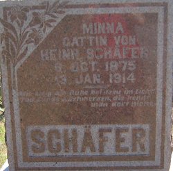
Wilhelmina “Minnie” Most Schäfer
| Birth | : | 9 Oct 1875 Fillmore County, Nebraska, USA |
| Death | : | 13 Jan 1914 Tobias, Saline County, Nebraska, USA |
| Burial | : | Monmouth Ridge Cemetery, Monmouth, Kennebec County, USA |
| Coordinate | : | 44.2066994, -70.0188980 |
| Plot | : | Row 6 |
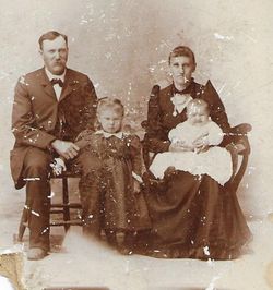
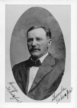
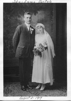
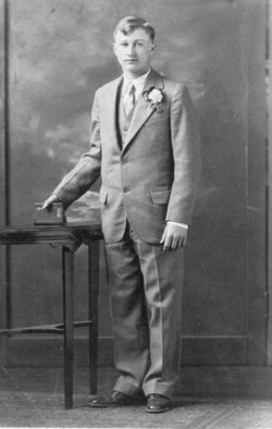
| Description | : | Wilhelmina, generally referred to as "Minnie" (although the German name of "Minna" is on her tombstone) was born to Hans Heinrich Most (known as "Henry") and Caroline Justine Wilhelmine Dorothea nee Heidemann. Minnie married Henry Schafer in 1894 at the Zion Lutheran church outside of Tobias, Nebraska. They had 9 children: Fred, Margaret, Emma, Hannah, Elizabeth ("Lisbet"), Ernst, Louis, Leonard, and Seibert, all of whom were still living when she died. Her death was as the result of tuberculosis. |
frequently asked questions (FAQ):
-
Where is Wilhelmina “Minnie” Most Schäfer's memorial?
Wilhelmina “Minnie” Most Schäfer's memorial is located at: Monmouth Ridge Cemetery, Monmouth, Kennebec County, USA.
-
When did Wilhelmina “Minnie” Most Schäfer death?
Wilhelmina “Minnie” Most Schäfer death on 13 Jan 1914 in Tobias, Saline County, Nebraska, USA
-
Where are the coordinates of the Wilhelmina “Minnie” Most Schäfer's memorial?
Latitude: 44.2066994
Longitude: -70.0188980
Family Members:
Parent

Spouse
Siblings
Children
Flowers:


Nearby Cemetories:
1. Monmouth Ridge Cemetery
Monmouth, Kennebec County, USA
Coordinate: 44.2066994, -70.0188980
2. South Monmouth Cemetery
Monmouth, Kennebec County, USA
Coordinate: 44.1956263, -69.9914698
3. Lyons Cemetery
Monmouth, Kennebec County, USA
Coordinate: 44.2215800, -69.9830900
4. Monmouth Center Cemetery
Monmouth, Kennebec County, USA
Coordinate: 44.2404600, -70.0349000
5. Woodbury Cemetery
Litchfield, Kennebec County, USA
Coordinate: 44.2021430, -69.9597790
6. Packard Road Cemetery
Monmouth, Kennebec County, USA
Coordinate: 44.2387500, -70.0600200
7. East Monmouth Cemetery
Monmouth, Kennebec County, USA
Coordinate: 44.2400400, -69.9791100
8. Pease Hill Cemetery
Monmouth, Kennebec County, USA
Coordinate: 44.2163900, -69.9589200
9. Woodbury-Goodwin Cemetery
Litchfield, Kennebec County, USA
Coordinate: 44.2088260, -69.9497330
10. Pond Road Cemetery
Wales, Androscoggin County, USA
Coordinate: 44.1727982, -70.0717010
11. Keenes Corner Cemetery
Leeds, Androscoggin County, USA
Coordinate: 44.2183500, -70.0903300
12. East Wales Cemetery
East Wales, Androscoggin County, USA
Coordinate: 44.1534805, -70.0403671
13. Lakeview Cemetery
Monmouth, Kennebec County, USA
Coordinate: 44.2637900, -70.0314300
14. Mitchell Cemetery
Litchfield, Kennebec County, USA
Coordinate: 44.1487100, -70.0162100
15. North Litchfield Cemetery
Litchfield, Kennebec County, USA
Coordinate: 44.1877660, -69.9391900
16. Purgatory Village Cemetery
Litchfield, Kennebec County, USA
Coordinate: 44.2184900, -69.9320400
17. Leeds Plains Cemetery
Leeds, Androscoggin County, USA
Coordinate: 44.2433014, -70.0958023
18. Line Cemetery
Leeds, Androscoggin County, USA
Coordinate: 44.2231903, -70.1089096
19. Pleasant Point Cemetery
Monmouth, Kennebec County, USA
Coordinate: 44.2761910, -70.0296450
20. Maxwell Cemetery
Litchfield, Kennebec County, USA
Coordinate: 44.1365700, -70.0135700
21. Morse Cemetery
Greene, Androscoggin County, USA
Coordinate: 44.2078018, -70.1194000
22. Grant Cemetery
Litchfield, Kennebec County, USA
Coordinate: 44.1810000, -69.9240800
23. Monmouth Neck Cemetery
Monmouth, Kennebec County, USA
Coordinate: 44.2604200, -69.9492600
24. Litchfield Plains Cemetery
Litchfield, Kennebec County, USA
Coordinate: 44.1519012, -69.9421997