

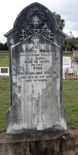
Wilhelmine Auguste Wandschneider Kahler
| Birth | : | Aug 1835 Kiel, Stadtkreis Kiel, Schleswig-Holstein, Germany |
| Death | : | 20 Sep 1914 Maryborough, Fraser Coast Region, Queensland, Australia |
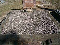
| Burial | : | Maryborough Cemetery, Maryborough, Fraser Coast Region, Australia |
| Coordinate | : | -25.5165460, 152.6735930 |
| Plot | : | Monumental B. Plot 580 |
| Description | : | Married Heinrich Kahler in Germany. This family arrived on board the "Susanne Godeffroy" 6th September, 1865 - Henrich aged 31, his wife Wilhelmine aged 30, and their daughter Magdalene aged 2 months. ...[Queensland Immigration Records: IMM/113 P62 M1696] Death Notice - Maryborough Chronicle dated Monday, September 21, 1914: KAHLER - On the 20th September, 1914, at Island Plantation, Wilhelmine Auguste Sophie Kahler, beloved mother of Wilhelm Kahler, aged 79 years and one month. OBITUARY - Maryborough Chronicle dated Monday, September 21, 1914 We have to record the death of a very old resident of the Island Plantation, under tragic circumstances, in the person of Mrs Wilhelmine... Read More |
frequently asked questions (FAQ):
-
Where is Wilhelmine Auguste Wandschneider Kahler's memorial?
Wilhelmine Auguste Wandschneider Kahler's memorial is located at: Maryborough Cemetery, Maryborough, Fraser Coast Region, Australia.
-
When did Wilhelmine Auguste Wandschneider Kahler death?
Wilhelmine Auguste Wandschneider Kahler death on 20 Sep 1914 in Maryborough, Fraser Coast Region, Queensland, Australia
-
Where are the coordinates of the Wilhelmine Auguste Wandschneider Kahler's memorial?
Latitude: -25.5165460
Longitude: 152.6735930
Family Members:
Spouse
Children

Flowers:


Nearby Cemetories:
1. Maryborough Cemetery
Maryborough, Fraser Coast Region, Australia
Coordinate: -25.5165460, 152.6735930
2. Maryborough Lawn Cemetery
Maryborough, Fraser Coast Region, Australia
Coordinate: -25.5126410, 152.6731850
3. Maryborough Crematorium
Maryborough, Fraser Coast Region, Australia
Coordinate: -25.5116294, 152.6716756
4. Maryborough Pioneer Cemetery
Maryborough, Fraser Coast Region, Australia
Coordinate: -25.5232830, 152.6746380
5. Elizabeth Park Rose Gardens
Maryborough, Fraser Coast Region, Australia
Coordinate: -25.5317100, 152.6952600
6. Commissioner Bidwill's Grave
Maryborough, Fraser Coast Region, Australia
Coordinate: -25.5631670, 152.7110000
7. Barlows Farm Cemetery
Takura, Fraser Coast Region, Australia
Coordinate: -25.3330030, 152.7191200
8. Tiaro Cemetery
Tiaro, Fraser Coast Region, Australia
Coordinate: -25.7173650, 152.5856850
9. Aalborg Danish Cemetery
Nikenbah, Fraser Coast Region, Australia
Coordinate: -25.3169800, 152.8047240
10. Bayside Gardens Crematorium
Nikenbah, Fraser Coast Region, Australia
Coordinate: -25.3135540, 152.8020030
11. Howard Remembrance Park
Howard, Fraser Coast Region, Australia
Coordinate: -25.3054360, 152.5470520
12. Hervey Bay Crematorium
Hervey Bay, Fraser Coast Region, Australia
Coordinate: -25.2991870, 152.8075780
13. Polson Cemetery
Point Vernon, Fraser Coast Region, Australia
Coordinate: -25.2522717, 152.8135186
14. Deborah Cemetery
Netherby, Fraser Coast Region, Australia
Coordinate: -25.7827119, 152.4940048
15. Big Woody Island Cemetery
Hervey Bay, Fraser Coast Region, Australia
Coordinate: -25.2828650, 152.9544730
16. St Mary's Anglican Churchyard
Brooweena, Fraser Coast Region, Australia
Coordinate: -25.6155810, 152.2342900
17. Munna Creek Cemetery
Gundiah, Fraser Coast Region, Australia
Coordinate: -25.8943010, 152.4806150
18. Agnes Vale Station Cemetery
Childers, Bundaberg Region, Australia
Coordinate: -25.2720660, 152.2496070
19. Childers Lawn Cemetery
Childers, Bundaberg Region, Australia
Coordinate: -25.2241618, 152.2642764
20. Dickabram Cemetery
Miva, Gympie Region, Australia
Coordinate: -25.9604510, 152.4848260
21. Gunalda Cemetery
Gunalda, Gympie Region, Australia
Coordinate: -25.9877920, 152.5557680
22. Tozer Park Cemetery (Defunct)
Gympie, Gympie Region, Australia
Coordinate: -26.0008330, 152.7438890
23. Neerdie Cemetery
Gympie, Gympie Region, Australia
Coordinate: -26.0008540, 152.7442570
24. Apple Tree Creek Cemetery
Apple Tree Creek, Bundaberg Region, Australia
Coordinate: -25.2254030, 152.2386650