
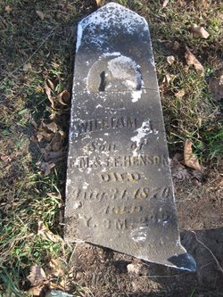
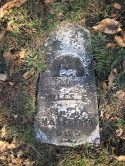
William A. Henson
| Birth | : | 8 May 1868 Monterey, Davis County, Iowa, USA |
| Death | : | 31 Aug 1870 Monterey, Davis County, Iowa, USA |
| Burial | : | Gregory Neil Gentry Cemetery, White Springs, Liberty County, USA |
| Coordinate | : | 30.4217020, -84.9192700 |
| Description | : | William A. Henson was born 8 May 1868 in Davis County, Iowa, to Francis M. and Sarah Frances (Burgher) Henson. He died shortly after his 2nd birthday on 31 August 1870. |
frequently asked questions (FAQ):
-
Where is William A. Henson's memorial?
William A. Henson's memorial is located at: Gregory Neil Gentry Cemetery, White Springs, Liberty County, USA.
-
When did William A. Henson death?
William A. Henson death on 31 Aug 1870 in Monterey, Davis County, Iowa, USA
-
Where are the coordinates of the William A. Henson's memorial?
Latitude: 30.4217020
Longitude: -84.9192700
Family Members:
Parent
Siblings
Flowers:


Nearby Cemetories:
1. Gregory Neil Gentry Cemetery
White Springs, Liberty County, USA
Coordinate: 30.4217020, -84.9192700
2. Meacham Cemetery
Bristol, Liberty County, USA
Coordinate: 30.4311008, -84.9486008
3. Pleasant Hill Cemetery
Bristol, Liberty County, USA
Coordinate: 30.4077650, -84.9530820
4. Twin Oaks Cemetery
Bristol, Liberty County, USA
Coordinate: 30.4164200, -84.9727300
5. Bristol Cemetery
Bristol, Liberty County, USA
Coordinate: 30.4343700, -84.9800000
6. Lake Mystic Cemetery
Bristol, Liberty County, USA
Coordinate: 30.3942270, -84.9740570
7. Life More Abundant Church Cemetery
Bristol, Liberty County, USA
Coordinate: 30.3839000, -84.9696000
8. Anders Family Cemetery
Bristol, Liberty County, USA
Coordinate: 30.3807180, -84.9707700
9. Sanders Cemetery
Hosford, Liberty County, USA
Coordinate: 30.3951200, -84.8122140
10. Potter Family Cemetery
Bristol, Liberty County, USA
Coordinate: 30.3435300, -84.9854530
11. Watson Cemetery
Bristol, Liberty County, USA
Coordinate: 30.5128000, -84.9725000
12. Gadsden Street Cemetery
Blountstown, Calhoun County, USA
Coordinate: 30.4362826, -85.0376214
13. Elkins Family Cemetery
Hosford, Liberty County, USA
Coordinate: 30.3842720, -84.8038850
14. Stone Cemetery
Calhoun County, USA
Coordinate: 30.4884090, -85.0189450
15. Telogia Baptist Church Cemetery
Telogia, Liberty County, USA
Coordinate: 30.3535880, -84.8186600
16. Hosford Cemetery
Hosford, Liberty County, USA
Coordinate: 30.3823900, -84.7987060
17. Brown Cemetery
Hosford, Liberty County, USA
Coordinate: 30.3594300, -84.8079700
18. Wesleyan Chapel Cemetery
Hosford, Liberty County, USA
Coordinate: 30.3588900, -84.8003400
19. Nettle Ridge Cemetery
Blountstown, Calhoun County, USA
Coordinate: 30.4789009, -85.0441971
20. Boggs Cemetery
Blountstown, Calhoun County, USA
Coordinate: 30.4433002, -85.0616989
21. Magnolia Cemetery
Blountstown, Calhoun County, USA
Coordinate: 30.4455290, -85.0615060
22. J.C. Whittle Cemetery
Bristol, Liberty County, USA
Coordinate: 30.5299889, -84.8452306
23. Rock Bluff Cemetery
Rock Bluff, Liberty County, USA
Coordinate: 30.5471670, -84.9092290
24. Summerlin Family Cemetery
Hosford, Liberty County, USA
Coordinate: 30.3322030, -84.8156920