
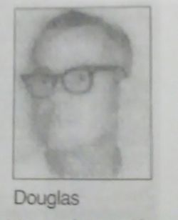
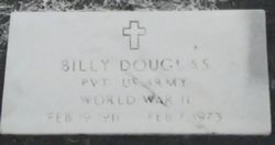
William “Billy” Douglas
| Birth | : | 19 Feb 1911 |
| Death | : | 1973 North, Orangeburg County, South Carolina, USA |
| Burial | : | Oak Ridge Cemetery, Arcadia, DeSoto County, USA |
| Coordinate | : | 27.2264004, -81.8694000 |
| Description | : | His remains were found by hunters near Bull Swamp Baptist Church in North. He had been missing since the big snow storm of 1973. It is believed he died from exposure to the cold. He was identified by his driver's license which was found in his wallet beside his remains. |
frequently asked questions (FAQ):
-
Where is William “Billy” Douglas's memorial?
William “Billy” Douglas's memorial is located at: Oak Ridge Cemetery, Arcadia, DeSoto County, USA.
-
When did William “Billy” Douglas death?
William “Billy” Douglas death on 1973 in North, Orangeburg County, South Carolina, USA
-
Where are the coordinates of the William “Billy” Douglas's memorial?
Latitude: 27.2264004
Longitude: -81.8694000
Family Members:
Parent

Spouse
Siblings

Flowers:


Nearby Cemetories:
1. Oak Ridge Cemetery
Arcadia, DeSoto County, USA
Coordinate: 27.2264004, -81.8694000
2. Saint Edmund Episcopal Church Columbarium
Arcadia, DeSoto County, USA
Coordinate: 27.2176980, -81.8640790
3. Trinity United Methodist Columbarium
Arcadia, DeSoto County, USA
Coordinate: 27.2168390, -81.8640150
4. Oak Hill Cemetery
Arcadia, DeSoto County, USA
Coordinate: 27.2457730, -81.8991580
5. Kabrich Cemetery
Nocatee, DeSoto County, USA
Coordinate: 27.1698100, -81.8597000
6. Peace River Mennonite Cemetery
Arcadia, DeSoto County, USA
Coordinate: 27.2000650, -81.9284800
7. Owens Cemetery
Arcadia, DeSoto County, USA
Coordinate: 27.1833000, -81.9233017
8. Mount Olive Cemetery
Nocatee, DeSoto County, USA
Coordinate: 27.1615700, -81.8885000
9. Joshua Creek Cemetery
Arcadia, DeSoto County, USA
Coordinate: 27.1825008, -81.8028030
10. Indian Mound Cemetery
Arcadia, DeSoto County, USA
Coordinate: 27.2520220, -81.9843050
11. Pine Level Camp Grounds Cemetery
Pine Level, DeSoto County, USA
Coordinate: 27.2650394, -81.9986930
12. Coker Cemetery
Limestone, Hardee County, USA
Coordinate: 27.3514004, -81.8510971
13. Hull Cemetery
Arcadia, DeSoto County, USA
Coordinate: 27.1152992, -81.9494019
14. Gardner Cemetery
Zolfo Springs, Hardee County, USA
Coordinate: 27.3480000, -81.8029010
15. King Cemetery
Fort Ogden, DeSoto County, USA
Coordinate: 27.0869500, -81.9563100
16. Lily Cemetery
Lily, Hardee County, USA
Coordinate: 27.3643980, -81.9773480
17. Fort Ogden Cemetery
Fort Ogden, DeSoto County, USA
Coordinate: 27.0795612, -81.9651031
18. Jernigan Family Plot
Arcadia, DeSoto County, USA
Coordinate: 27.1030800, -82.0080700
19. Locklar Cemetery
Zolfo Springs, Hardee County, USA
Coordinate: 27.4012990, -81.7026930
20. Sweetwater Cemetery
Sweetwater, Hardee County, USA
Coordinate: 27.4055784, -81.7002807
21. Friendship Methodist Cemetery
Zolfo Springs, Hardee County, USA
Coordinate: 27.4553697, -81.7752567
22. Oak Grove Community Cemetery
Hardee County, USA
Coordinate: 27.4710999, -81.8600006
23. Zolfo Springs Baptist Church Cemetery
Zolfo Springs, Hardee County, USA
Coordinate: 27.4888990, -81.7914080
24. Huckeby Cemetery
Cleveland, Charlotte County, USA
Coordinate: 26.9718136, -81.9824299