
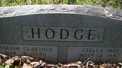
William Clarence Hodge
| Birth | : | 20 Mar 1885 Missouri, USA |
| Death | : | 4 Mar 1934 Miller County, Missouri, USA |
| Burial | : | Piney Creek Church of the Brethren Cemetery, Taneytown, Carroll County, USA |
| Coordinate | : | 39.7033005, -77.1536026 |
| Description | : | Born 20-Mar-1885, died 4-Mar-1934 in Osage, Miller County, Missouri, per his death certificate. Married Stella Abbett on 26-Nov-1908 per Missouri marriage license. Obituary, from The Miller County Autogram, Thursday, March 15, 1934: William Clarence Hodge was born March 20, 1885; married to Miss Stella Abbott in 1907 [sic]; entered eternal rest March 4, 1934; buried in Capps Cemetery March 6. Funeral services were conducted at place of interment by Rev. J.D. Barnhart in the midst of quite a large audience of relatives and sorrowing friends. Pallbearers were Willie Grosvenor, Sterl Cross, George Birdsong,... Read More |
frequently asked questions (FAQ):
-
Where is William Clarence Hodge's memorial?
William Clarence Hodge's memorial is located at: Piney Creek Church of the Brethren Cemetery, Taneytown, Carroll County, USA.
-
When did William Clarence Hodge death?
William Clarence Hodge death on 4 Mar 1934 in Miller County, Missouri, USA
-
Where are the coordinates of the William Clarence Hodge's memorial?
Latitude: 39.7033005
Longitude: -77.1536026
Family Members:
Spouse
Children

Flowers:


Nearby Cemetories:
1. Piney Creek Church of the Brethren Cemetery
Taneytown, Carroll County, USA
Coordinate: 39.7033005, -77.1536026
2. Saint James Reformed Cemetery
Mount Joy Township, Adams County, USA
Coordinate: 39.7312000, -77.1583000
3. Piney Creek Reformed Presbyterian Church Cemetery
Taneytown, Carroll County, USA
Coordinate: 39.6984500, -77.1977600
4. Sunrise Cemetery
Harney, Carroll County, USA
Coordinate: 39.7125015, -77.2031021
5. Trinity Lutheran Cemetery
Taneytown, Carroll County, USA
Coordinate: 39.6626900, -77.1760600
6. Mountain View Cemetery
Harney, Carroll County, USA
Coordinate: 39.7196500, -77.2098600
7. Grace United Church of Christ Cemetery
Taneytown, Carroll County, USA
Coordinate: 39.6610000, -77.1795800
8. Saint Josephs Catholic Church Cemetery
Taneytown, Carroll County, USA
Coordinate: 39.6579800, -77.1791900
9. Baptist Road Cemetery
Taneytown, Carroll County, USA
Coordinate: 39.6706900, -77.2023900
10. Saint John's Lutheran Cemetery
Germany Township, Adams County, USA
Coordinate: 39.7434000, -77.1030000
11. Mount Pleasant United Methodist Cemetery
Taneytown, Carroll County, USA
Coordinate: 39.6455994, -77.1508026
12. Mount Carmel Cemetery
Littlestown, Adams County, USA
Coordinate: 39.7397003, -77.0892029
13. Saint Aloysius Cemetery
Germany Township, Adams County, USA
Coordinate: 39.7364006, -77.0793991
14. Mount Joy Cemetery
Mount Joy Township, Adams County, USA
Coordinate: 39.7479000, -77.2228000
15. Benner Mausoleum
Mount Joy Township, Adams County, USA
Coordinate: 39.7460190, -77.2280750
16. Elizabeth Horn Gravesite
Arters Mill, Carroll County, USA
Coordinate: 39.6646700, -77.0717900
17. Mayberry First Church of God Cemetery
Mayberry, Carroll County, USA
Coordinate: 39.6417800, -77.0985300
18. Two Taverns Cemetery
Mount Joy Township, Adams County, USA
Coordinate: 39.7789000, -77.1676000
19. Saint Marys Cemetery
Silver Run, Carroll County, USA
Coordinate: 39.6844100, -77.0490800
20. Pine Bank Cemetery
Mount Joy Township, Adams County, USA
Coordinate: 39.7761002, -77.2080994
21. Emmanuel Baust Church Cemetery
Westminster, Carroll County, USA
Coordinate: 39.6215400, -77.1002700
22. Christ United Church of Christ Cemetery
Union Township, Adams County, USA
Coordinate: 39.7566681, -77.0558319
23. Saint Mark's Reformed Cemetery
Mount Joy Township, Adams County, USA
Coordinate: 39.7918000, -77.1925000
24. Saint Luke's Lutheran Church Cemetery
Mount Pleasant Township, Adams County, USA
Coordinate: 39.8006150, -77.1200140